Difference between revisions of "2009-11-23 51 -1"
(→Participants) |
imported>FippeBot m (Location) |
||
| (2 intermediate revisions by one other user not shown) | |||
| Line 6: | Line 6: | ||
== Location == | == Location == | ||
| + | Just off the A34, along a bridleway. | ||
== Participants == | == Participants == | ||
* [[User:Joehardflec|Joehardflec]] from [[Birmingham, United Kingdom|Birmingham]] graticule. | * [[User:Joehardflec|Joehardflec]] from [[Birmingham, United Kingdom|Birmingham]] graticule. | ||
| − | |||
| − | |||
| − | |||
| − | |||
== Expedition == | == Expedition == | ||
| − | + | ===Journey=== | |
| − | '' | + | Joe went down to Portsmouth for a job interview the next day, and seeing as the hashpoint was so close to my intended route down the A34, and was also near an interestingly named village, I figured it had to be done. |
| + | I arrived at World's End around 13:50, after passing very close to the hashpoint on the sliproad off the '34. | ||
| + | The weather had been on-and-off heavy showers with sunny spells all the way down from Leicester, and it was chucking it down when I arrived. I parked up at the pub at World's End, and waited out the shower, seeing a clear patch of sky approaching. However, I still kitted up with full waterproofs just in case the rain came back faster than I expected. | ||
| + | Anyway, I set off for the point, following a path that looked like it went under the 34 at some point, but it never did, and I ended up taking an alternate route along another footpath that barely existed any more, to reach the bridleway. | ||
| + | ===Hashpoint=== | ||
| + | I found the hashpoint, just off the bridleway, and took a quick diversion down a little bank to the exact point. I then headed back to World's End, mostly avoiding the rain. | ||
== Gallery == | == Gallery == | ||
| + | <gallery perrow="3"> | ||
| + | Image:2009-11-23 51 -1 WorldsEnd.jpg | World's End sign | ||
| + | Image:2009-11-23 51 -1 GPS.jpg | Near-as-damnit the right co-ords. It works if you truncate the figures, but not if you round. | ||
| + | </gallery> | ||
| − | |||
| − | [[Category: | + | [[Category:Expeditions]] |
| + | [[Category:Expeditions with photos]] | ||
| + | [[Category:Coordinates reached]] | ||
| + | [[Category:Meetup on 2009-11-23]] | ||
| + | [[Category:Meetup in 51 -1]] | ||
| + | {{location|GB|ENG|WBK}} | ||
Latest revision as of 06:55, 8 August 2019
| Mon 23 Nov 2009 in 51,-1: 51.4980852, -1.2904900 geohashing.info google osm bing/os kml crox |
Location
Just off the A34, along a bridleway.
Participants
- Joehardflec from Birmingham graticule.
Expedition
Journey
Joe went down to Portsmouth for a job interview the next day, and seeing as the hashpoint was so close to my intended route down the A34, and was also near an interestingly named village, I figured it had to be done. I arrived at World's End around 13:50, after passing very close to the hashpoint on the sliproad off the '34. The weather had been on-and-off heavy showers with sunny spells all the way down from Leicester, and it was chucking it down when I arrived. I parked up at the pub at World's End, and waited out the shower, seeing a clear patch of sky approaching. However, I still kitted up with full waterproofs just in case the rain came back faster than I expected. Anyway, I set off for the point, following a path that looked like it went under the 34 at some point, but it never did, and I ended up taking an alternate route along another footpath that barely existed any more, to reach the bridleway.
Hashpoint
I found the hashpoint, just off the bridleway, and took a quick diversion down a little bank to the exact point. I then headed back to World's End, mostly avoiding the rain.
Gallery
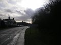
World's End sign
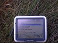
Near-as-damnit the right co-ords. It works if you truncate the figures, but not if you round.

