Difference between revisions of "2009-12-30 47 11"
imported>Zb (Yay! 2009-12-30 47 11) |
imported>FippeBot m (Location) |
||
| (3 intermediate revisions by one other user not shown) | |||
| Line 1: | Line 1: | ||
| − | |||
<!-- If you did not specify these parameters in the template, please substitute appropriate things for IMAGE, LAT, LON, and DATE (YYYY-MM-DD format) | <!-- If you did not specify these parameters in the template, please substitute appropriate things for IMAGE, LAT, LON, and DATE (YYYY-MM-DD format) | ||
| Line 14: | Line 13: | ||
<!-- edit as necessary --> | <!-- edit as necessary --> | ||
__NOTOC__ | __NOTOC__ | ||
| − | + | In a forest approx. 250 m NW of the edge of the little lake ''Aufhofener Weiher'' next to the village of Aufhofen. | |
| − | |||
== Participants == | == Participants == | ||
| − | + | [[User:Zb|zb]] went by bike in the afternoon. | |
== Plans == | == Plans == | ||
| + | [http://maps.google.com/maps?q=loc:(47.940863,11.520885) 2009-12-30 47 11] might be kind of hard without a GPS and just using landmarks. I still might go check it out by bike in the early afternoon, depending on how promising the [http://www.niederschlagsradar.de/h.aspx?regio=muc&j=-3&srt=loop2stunde weather] will look. --[[User:Zb|Zb]] 09:07, 30 December 2009 (UTC) | ||
| + | == Narrative == | ||
| + | It was a semi-nice bike ride to the spot. Getting out of Munich through the Southern suburbs was fun, but some roads in the woods just North of the location were steep and icy and no pleasure at all. Just when I thought I had completely gotten lost, I came to the edge of the forest overlooking the little lake and the village of Aufhausen. The landmarks I had seen on the satellite images were actually good enough for me to get close enough for calling this one a success. | ||
| − | == | + | == Photos == |
| + | Preparing, ... | ||
| − | = | + | <gallery perrow="4"> |
| + | Image:2009-12-30_47_11_zb_0127.jpg | The map that I had with me, on the display of my camera. | ||
| + | </gallery> | ||
| − | + | ... going there, ... | |
| − | |||
<gallery perrow="4"> | <gallery perrow="4"> | ||
| − | Image:2009- | + | Image:2009-12-30_47_11_zb_0128.jpg | Looking towards the Alps along the Autobahn A8. |
| − | Image:2009- | + | Image:2009-12-30_47_11_zb_0130.jpg | Looking towards the Alps along KBS 955/956/999.3 from the bridge of St2368 SE of Deisenhofen. |
| + | Image:2009-12-30_47_11_zb_0131.jpg | The further you get South of the City, the greener it gets between you and the Alps. Note how the Föhn winds from the South fight the clouds from the North. It isn't raining ''yet''. | ||
| + | Image:2009-12-30_47_11_zb_0134.jpg | Kitty! | ||
| + | Image:2009-12-30_47_11_zb_0135.jpg | Mists along the way to the Geohash. | ||
| + | Image:2009-12-30_47_11_zb_0136.jpg | How not-helpful can it get? I felt increasingly lost. | ||
| + | Image:2009-12-30_47_11_zb_0137.jpg | Biking downhill on unpaved and icy roads like these makes you go very slow and careful. | ||
| + | Image:2009-12-30_47_11_zb_0138.jpg | Aufhofener Weiher! Just when I thought I had gotten totally lost. | ||
| + | Image:2009-12-30_47_11_zb_0141.jpg | A bend on a forest road that I also found on a bike map. This is already really close to the coords. | ||
| + | Image:2009-12-30_47_11_zb_0142.jpg | A clearcut in the woods, starting close to the coords, going WSW. | ||
| + | Image:2009-12-30_47_11_zb_0143.jpg | An open space WNW of the location. The method of transportation is at the S end of the clearcut. Going E from here for about as long as the clearcut extends N would bring me very close to where ''The Location'' must be! | ||
| + | Image:2009-12-30_47_11_zb_0145.jpg | The ground around the location was ''very'' green. The camera flash even makes the dim light go away. I was positive I was within some meters of where a GPS would have said ''zero''. | ||
</gallery> | </gallery> | ||
| − | |||
| − | + | ... and home again, in the rain. | |
| − | |||
| − | < | + | <gallery perrow="2"> |
| − | + | Image:2009-12-30_47_11_zb_0147.jpg | Looking NW over ''Aufhofener Weiher''. The location is somewhat straight ahead, in the woods. | |
| − | + | Image:2009-12-30_47_11_zb_0149.jpg | Again, this time from Aufhofen. Some old, but obviously well maintained machinery is in the foreground. | |
| − | --> | + | Image:2009-12-30_47_11_zb_0153.jpg | Leaving the South... |
| + | Image:2009-12-30_47_11_zb_0151.jpg | ... and re-entering München Land. | ||
| + | Image:2009-12-30_47_11_zb_0156.jpg | RR Xing in Perlach with a S-Bahn train. It had started to rain. It got cold. | ||
| + | Image:2009-12-30_47_11_zb_0160.jpg | Some folks were a day and some hours early shooting New Year's fireworks back home in Berg am Laim. | ||
| + | </gallery> | ||
| − | |||
[[Category:Expeditions]] | [[Category:Expeditions]] | ||
| − | |||
[[Category:Expeditions with photos]] | [[Category:Expeditions with photos]] | ||
| − | |||
[[Category:Expedition without GPS]] | [[Category:Expedition without GPS]] | ||
| − | |||
| − | |||
| − | |||
[[Category:Coordinates reached]] | [[Category:Coordinates reached]] | ||
| − | + | {{location|DE|BY|TÖL}} | |
| − | |||
| − | |||
| − | |||
| − | |||
| − | |||
| − | |||
| − | |||
| − | |||
| − | |||
Latest revision as of 00:20, 9 August 2019
| Wed 30 Dec 2009 in 47,11: 47.9408633, 11.5208850 geohashing.info google osm bing/os kml crox |
In a forest approx. 250 m NW of the edge of the little lake Aufhofener Weiher next to the village of Aufhofen.
Participants
zb went by bike in the afternoon.
Plans
2009-12-30 47 11 might be kind of hard without a GPS and just using landmarks. I still might go check it out by bike in the early afternoon, depending on how promising the weather will look. --Zb 09:07, 30 December 2009 (UTC)
Narrative
It was a semi-nice bike ride to the spot. Getting out of Munich through the Southern suburbs was fun, but some roads in the woods just North of the location were steep and icy and no pleasure at all. Just when I thought I had completely gotten lost, I came to the edge of the forest overlooking the little lake and the village of Aufhausen. The landmarks I had seen on the satellite images were actually good enough for me to get close enough for calling this one a success.
Photos
Preparing, ...
The map that I had with me, on the display of my camera.

... going there, ...
Looking towards the Alps along the Autobahn A8.
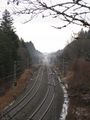
Looking towards the Alps along KBS 955/956/999.3 from the bridge of St2368 SE of Deisenhofen.
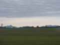
The further you get South of the City, the greener it gets between you and the Alps. Note how the Föhn winds from the South fight the clouds from the North. It isn't raining yet.
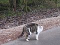
Kitty!
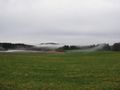
Mists along the way to the Geohash.
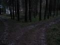
How not-helpful can it get? I felt increasingly lost.
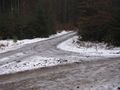
Biking downhill on unpaved and icy roads like these makes you go very slow and careful.
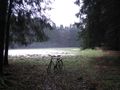
Aufhofener Weiher! Just when I thought I had gotten totally lost.
A bend on a forest road that I also found on a bike map. This is already really close to the coords.
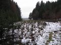
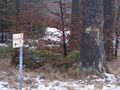
A clearcut in the woods, starting close to the coords, going WSW.
An open space WNW of the location. The method of transportation is at the S end of the clearcut. Going E from here for about as long as the clearcut extends N would bring me very close to where The Location must be!
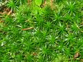
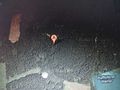
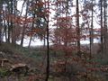
The ground around the location was very green. The camera flash even makes the dim light go away. I was positive I was within some meters of where a GPS would have said zero.


... and home again, in the rain.
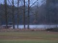
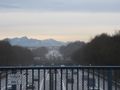
Looking NW over Aufhofener Weiher. The location is somewhat straight ahead, in the woods.
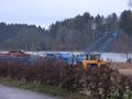
Again, this time from Aufhofen. Some old, but obviously well maintained machinery is in the foreground.
Leaving the South...

... and re-entering München Land.
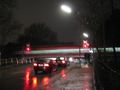
RR Xing in Perlach with a S-Bahn train. It had started to rain. It got cold.
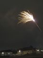
Some folks were a day and some hours early shooting New Year's fireworks back home in Berg am Laim.


