Difference between revisions of "2010-02-04 45 -122"
From Geohashing
imported>Michael5000 m (→Tracklog) |
imported>Michael5000 m |
||
| Line 1: | Line 1: | ||
| − | |||
{{meetup graticule | {{meetup graticule | ||
| lat=45 | | lat=45 | ||
| Line 37: | Line 36: | ||
[[Category:New report]] | [[Category:New report]] | ||
| − | |||
| − | |||
| − | |||
| − | |||
| − | |||
[[Category:Expeditions]] | [[Category:Expeditions]] | ||
| − | |||
[[Category:Expeditions with photos]] | [[Category:Expeditions with photos]] | ||
| − | |||
[[Category:Expedition without GPS]] | [[Category:Expedition without GPS]] | ||
| − | |||
| − | |||
| − | |||
[[Category:Coordinates reached]] | [[Category:Coordinates reached]] | ||
| − | |||
| − | |||
| − | |||
| − | |||
| − | |||
| − | |||
| − | |||
| − | |||
| − | |||
| − | |||
Revision as of 03:58, 5 February 2010
| Thu 4 Feb 2010 in 45,-122: 45.4465739, -122.6178369 geohashing.info google osm bing/os kml crox |
Location
Across the street from the back of a Safeway in Milwaukie.
Participants
Plans
It was a dark and stormy night. Michael5000 had had a crappy day at work. "The hash point is in Milwaukie," he told Mrs.5000. Want to go get it. "Oh, yes," she replied.
Expedition
We drove down 39th until we ran out of street, and then had to backtrack a long ways to get around the Johnson Creek corridor. Then we drove down Harrison Street, stopped at the hashpoint, and experienced the bliss of a successful hash.
Photos
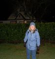
Mrs.5000 at the hashpoint.

The truck in a no truck parking zone. Hmm...

