Difference between revisions of "2010-02-08 43 -79"
imported>Splitdipless |
imported>Splitdipless |
||
| Line 12: | Line 12: | ||
<!-- edit as necessary --> | <!-- edit as necessary --> | ||
| − | |||
== Location == | == Location == | ||
| − | Satellite imagery suggests that the point is off on the shoulder of, or in a ditch beside Tauton Rd. in North Pickering. | + | Satellite imagery suggests that the point is off on the shoulder of, or in a ditch beside Tauton Rd. in North Pickering. It was found to be in the northern most (westbound) lane of traffic. |
| − | == | + | == Expedition == |
| − | |||
| − | == | + | === [[User:Splitdipless|Splitdipless]] and his Very Understanding Girlfriend === |
| − | + | ||
| − | + | A quick call to the Very Understanding Girlfriend and she was in. Seeing as it was just down the street from where she worked, so to speak. After picking her up and heading west into the setting sun, my Very Understanding Girlfriend started counting down the meters once we got within a kilometer. | |
| − | + | ||
| − | + | Eventually, she exclaimed: "0! Stop!" | |
| + | |||
| + | It would seem that the satellite image showing the point in the ditch was wrong. It was on the road. About 3 to 4 meters onto the road. So when I pulled off it and overshot by 40 meters, we passed through the point with Em, earning ourselves another Speed Racer achievement. | ||
| + | |||
| + | We got out and walked back to take pictures and get as close as we could to the hash point without endangering our lives. For some reason, my camera keeps switching modes on me, and the picture of the farmer's field on the other side of the shoulder turned out over-exposed. Looks interesting, but not nearly that bright out. | ||
| + | |||
| + | After dropping my Very Understanding Girlfriend to her car back at her work, she went and picked up a slushee, which is similar to what the [[GeoSquishy]] award is for. Saddly, the location she purchased the drink from was outside the 5km boundry to earn her 'first sip' award. | ||
| − | + | Also looking through the possible achievements, I just noticed the [[Frozen_Geohash|Frozen Geohash]] acheivement. If only I thought of taking a picture of the thermostat on my car! Next time... | |
| − | |||
== Photos == | == Photos == | ||
| − | |||
<gallery perrow="4"> | <gallery perrow="4"> | ||
| − | Image: | + | Image:2010-02-08 43 -79 0.7 A.jpg | Yay, for a group effort! |
| − | Image: | + | Image:2010-02-08 43 -79 0.7 B.jpg | I wasn't about to step out onto the road with an 80 km/h speed limit. |
| + | Image:2010-02-08 43 -79 0.7 C.jpg | What is with my camera and this over-exposed shot? | ||
| + | Image:2010-02-08 43 -79 0.7 D.jpg | We had to step back/forth a bit to get within the accuracy. | ||
</gallery> | </gallery> | ||
| − | |||
| − | |||
| − | |||
| − | |||
[[Category:Expeditions]] | [[Category:Expeditions]] | ||
| − | |||
[[Category:Expeditions with photos]] | [[Category:Expeditions with photos]] | ||
| − | |||
| − | |||
| − | |||
| − | |||
| − | |||
[[Category:Coordinates reached]] | [[Category:Coordinates reached]] | ||
| − | |||
| − | |||
| − | |||
| − | |||
| − | |||
| − | |||
| − | |||
| − | |||
| − | |||
| − | |||
Revision as of 03:14, 9 February 2010
| Mon 8 Feb 2010 in 43,-79: 43.8622101, -79.1484796 geohashing.info google osm bing/os kml crox |
Location
Satellite imagery suggests that the point is off on the shoulder of, or in a ditch beside Tauton Rd. in North Pickering. It was found to be in the northern most (westbound) lane of traffic.
Expedition
Splitdipless and his Very Understanding Girlfriend
A quick call to the Very Understanding Girlfriend and she was in. Seeing as it was just down the street from where she worked, so to speak. After picking her up and heading west into the setting sun, my Very Understanding Girlfriend started counting down the meters once we got within a kilometer.
Eventually, she exclaimed: "0! Stop!"
It would seem that the satellite image showing the point in the ditch was wrong. It was on the road. About 3 to 4 meters onto the road. So when I pulled off it and overshot by 40 meters, we passed through the point with Em, earning ourselves another Speed Racer achievement.
We got out and walked back to take pictures and get as close as we could to the hash point without endangering our lives. For some reason, my camera keeps switching modes on me, and the picture of the farmer's field on the other side of the shoulder turned out over-exposed. Looks interesting, but not nearly that bright out.
After dropping my Very Understanding Girlfriend to her car back at her work, she went and picked up a slushee, which is similar to what the GeoSquishy award is for. Saddly, the location she purchased the drink from was outside the 5km boundry to earn her 'first sip' award.
Also looking through the possible achievements, I just noticed the Frozen Geohash acheivement. If only I thought of taking a picture of the thermostat on my car! Next time...
Photos
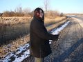
Yay, for a group effort!
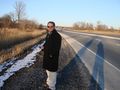
I wasn't about to step out onto the road with an 80 km/h speed limit.
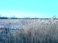
What is with my camera and this over-exposed shot?
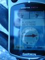
We had to step back/forth a bit to get within the accuracy.


