Difference between revisions of "2010-03-01 40 -89"
imported>Dvdllr |
imported>FippeBot m (Location) |
||
| (7 intermediate revisions by one other user not shown) | |||
| Line 6: | Line 6: | ||
}} | }} | ||
== Location == | == Location == | ||
| − | + | Parking lot of Dayton Freight building in East Peoria, Illinois | |
== Participants == | == Participants == | ||
| − | [[User:Dvdllr|Dvdllr]] | + | * [[User:Dvdllr|Dvdllr]] |
== Plans == | == Plans == | ||
| − | + | This one was too irresistable to pass up, since it was less than a mile from my office, and my commute takes me within 50 meters of the hashpoint anyway. I planned to stop by to see if it was accessible after work, so I went home for lunch and brought back my camera and GPS with me. | |
| − | |||
== Expedition == | == Expedition == | ||
| + | Hopped in the car after work, a few minutes before 4:00 PM, and typed the coordinates into the GPS. The dumb thing told me to get onto the interstate and then just get off when I'm near the hashpoint, so I didn't rely on it for directions (Recalculating... -Nüvi) But that was okay, since I had to make a grand total of four turns to get there anyway. In any case, I was most curious as to exactly how close I was to the destination while sitting in the parking lot. The GPS said 1.6 miles, and I figure that's pretty accurate as far as driving distance is concerned. As the crow flies, the destination and my cubicle's place in the world are about 1.1 km apart (0.7 miles). Not quite close enough for an honorable mention, but almost. | ||
| − | + | I had noted that from overhead views, this looked like a loading dock of sorts with the semi trailers. I also noted the fence all the way around the paved lot, so I went there fully expecting a No Trespassing Consolation Prize. But, upon arrival, the gate was open. It was, after all, a business day during normal working hours, so who's to say I wasn't there to visit Dayton Freight? There were visitor parking spaces. But foregoing too much rationalization, I didn't even get out of my car - I snapped some photos of the area and quietly excused myself. I'm sure I wasn't a problem being there, but I just didn't want to cause any trouble either. | |
| + | |||
| + | After completing this small jaunt, I went home. | ||
== Photos == | == Photos == | ||
| − | <gallery perrow="4 | + | <gallery perrow="5"> |
| − | Image: | + | Image:2010-03-01 40 -89 1.jpg | Silly GPS, I can't just jump off the interstate whenever I feel like |
| + | Image:2010-03-01 40 -89 2.jpg | Sign at the entrance | ||
| + | Image:2010-03-01 40 -89 3.jpg | A view of I-74 from the hashpoint... | ||
| + | Image:2010-03-01 40 -89 4.jpg | ...and a view of the dock... | ||
| + | Image:2010-03-01 40 -89 5.jpg | ...and finally, a view of the billboard. Mmm, Cracker Barrel | ||
| + | Image:2010-03-01 40 -89 6.jpg | The Stupid Grin<sup>tm</sup> | ||
| + | Image:2010-03-01 40 -89 7.jpg | Coordinate proof | ||
| + | Image:2010-03-01 40 -89 8.jpg | Time and date proof (it is next to impossible to get a clear picture of my phone!) | ||
| + | Image:2010-03-01 40 -89 Bing.JPG | Hashpoint, from Bing. Note the proximity to the billboard | ||
</gallery> | </gallery> | ||
| − | |||
| − | [[ | + | == Achievements == |
| + | {{#vardefine:ribbonwidth|800px}} | ||
| + | {{land geohash | ||
| + | |||
| + | | latitude = 40 | ||
| + | | longitude = -89 | ||
| + | | date = 2010-03-01 | ||
| + | | name = [[User:Dvdllr|Dvdllr]] | ||
| + | }} | ||
| + | {{cubicle geohash | ||
| + | |||
| + | | latitude = 40 | ||
| + | | longitude = -89 | ||
| + | | date = 2010-03-01 | ||
| + | | name = [[User:Dvdllr|Dvdllr]] | ||
| + | | honor = almost | ||
| + | }} | ||
| + | {{A Tale of Two Hashes challenge | ||
| + | |||
| + | | latitude = 40 | ||
| + | | longitude = -89 | ||
| + | | date = 2010-03-01 | ||
| + | | name = [[User:Dvdllr|Dvdllr]] | ||
| + | | place = [http://en.wikipedia.org/wiki/Dayton_(disambiguation) Dayton] | ||
| + | }} | ||
| + | {{Last man standing | ||
| + | | latitude = 40 | ||
| + | | longitude = -89 | ||
| + | | date = 2010-03-01 | ||
| + | | gender = man | ||
| + | | name = [[User:Dvdllr|Dvdllr]] | ||
| + | }} | ||
| + | {{Easy_geohash | ||
| + | |||
| + | | latitude = 40 | ||
| + | | longitude = -89 | ||
| + | | date = 2010-03-01 | ||
| + | | name = [[User:Dvdllr|Dvdllr]] | ||
| + | }} | ||
| + | |||
| − | |||
[[Category:Expeditions]] | [[Category:Expeditions]] | ||
| − | |||
[[Category:Expeditions with photos]] | [[Category:Expeditions with photos]] | ||
| − | |||
| − | |||
| − | |||
| − | |||
| − | |||
[[Category:Coordinates reached]] | [[Category:Coordinates reached]] | ||
| − | + | {{location|US|IL|TA}} | |
| − | |||
| − | |||
| − | |||
| − | |||
| − | |||
| − | |||
| − | |||
| − | |||
| − | |||
Latest revision as of 01:01, 9 August 2019
| Mon 1 Mar 2010 in 40,-89: 40.6752161, -89.5781895 geohashing.info google osm bing/os kml crox |
Location
Parking lot of Dayton Freight building in East Peoria, Illinois
Participants
Plans
This one was too irresistable to pass up, since it was less than a mile from my office, and my commute takes me within 50 meters of the hashpoint anyway. I planned to stop by to see if it was accessible after work, so I went home for lunch and brought back my camera and GPS with me.
Expedition
Hopped in the car after work, a few minutes before 4:00 PM, and typed the coordinates into the GPS. The dumb thing told me to get onto the interstate and then just get off when I'm near the hashpoint, so I didn't rely on it for directions (Recalculating... -Nüvi) But that was okay, since I had to make a grand total of four turns to get there anyway. In any case, I was most curious as to exactly how close I was to the destination while sitting in the parking lot. The GPS said 1.6 miles, and I figure that's pretty accurate as far as driving distance is concerned. As the crow flies, the destination and my cubicle's place in the world are about 1.1 km apart (0.7 miles). Not quite close enough for an honorable mention, but almost.
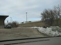
I had noted that from overhead views, this looked like a loading dock of sorts with the semi trailers. I also noted the fence all the way around the paved lot, so I went there fully expecting a No Trespassing Consolation Prize. But, upon arrival, the gate was open. It was, after all, a business day during normal working hours, so who's to say I wasn't there to visit Dayton Freight? There were visitor parking spaces. But foregoing too much rationalization, I didn't even get out of my car - I snapped some photos of the area and quietly excused myself. I'm sure I wasn't a problem being there, but I just didn't want to cause any trouble either.
After completing this small jaunt, I went home.
Photos
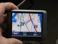
Silly GPS, I can't just jump off the interstate whenever I feel like

Sign at the entrance
A view of I-74 from the hashpoint...
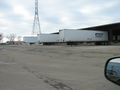
...and a view of the dock...
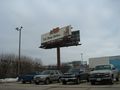
...and finally, a view of the billboard. Mmm, Cracker Barrel

The Stupid Grintm
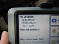
Coordinate proof
Time and date proof (it is next to impossible to get a clear picture of my phone!)

Hashpoint, from Bing. Note the proximity to the billboard


Achievements
Dvdllr earned the Land geohash achievement
|
Dvdllr earned the cubicle geohash almost honorable mention
|

Dvdllr earned the Last man standing achievement
|
Dvdllr has visited an Easy Geohash
|