Difference between revisions of "2010-03-08 -37 145"
imported>Kozz (Created page with '{{subst:Expedition |lat = -37 |lon = 145 |date = 2010-03-08 }}') |
m (More specific location) |
||
| (8 intermediate revisions by 3 users not shown) | |||
| Line 1: | Line 1: | ||
| − | |||
<!-- If you did not specify these parameters in the template, please substitute appropriate things for IMAGE, LAT, LON, and DATE (YYYY-MM-DD format) | <!-- If you did not specify these parameters in the template, please substitute appropriate things for IMAGE, LAT, LON, and DATE (YYYY-MM-DD format) | ||
| Line 15: | Line 14: | ||
__NOTOC__ | __NOTOC__ | ||
== Location == | == Location == | ||
| − | + | In a stand of trees, just off Skyline Road, north of Yarra Glen, Victoria | |
== Participants == | == Participants == | ||
| − | < | + | [[User:Kozz|Kozz]]<br/> |
| + | [[User:Kozz|Kozz]]'s dog <br/> | ||
| + | 1 x official [[New Zealand|Kiwi]] drag-along | ||
== Plans == | == Plans == | ||
| − | + | Driving up from Box Hill approx 11ish - hope to arrive 11 to 11.30am. | |
== Expedition == | == Expedition == | ||
| − | + | With a mate visiting from New Zealand and Monday being a public holiday, it made perfect sense to head out on a geohash today. I spotted the site not far from a road northwest of Yarra Glen, which I know reasonably well from previous driving excursions. | |
| + | |||
| + | Melbourne suffered some pretty nasty storms over the past couple of days so I figured there was a narrow window of opportunity to enjoy a sunny hash in the morning. We hit the road about 11am, and headed out towards Yarra Glen. Participants - myself, the dog, and my mate from NZ. | ||
| + | |||
| + | Arriving at Yarra Glen, my friend pointed out the direction to go up to Skyline Road, which Google Maps *assured* me was an actual road. I've run afoul of Google Maps before, so decided to reserve judgement until we actually got within sight of the hashpoint. | ||
| + | |||
| + | All was well, with sealed albeit narrow roads up to the crest of the hill, where Skyline Road split off. We turned off onto Skyline Road, and started driving through the forest towards the hashpoint. Shortly afterwards, I realised that our route would take us into a fire-affected area from last year's Black Saturday bushfires. Worse still, I saw a number of new houses - a clear indication that the area had been hit so hard that houses had been destroyed and were being rebuilt. I feel very conflicted about being a non-local in these areas; obviously it helps my understanding of the impact that the catastrophic fires had on the area, but I'm also aware that these people have lost everything and may have known people who died during the fires; wandering through their properties with a GPS seems a little irreverent. | ||
| + | |||
| + | We reached a fork in Skyline Road to discover a 'no further access by car, 4WD or horse' sign, and a gate across the road. Nearby were some logging trucks and a pile of cut logs, a vehicle trailer, and a driveway leading up to the crest of a hill. Figuring we should at least try to find our way towards the hashpoint, I got the dog out of the car, and we started up the hill. | ||
| + | |||
| + | Halfway down we were met by two official logging-looking people driving a mini bulldozer, the one apparently belonging to the trailer. They asked what we were up to, we explained, they said 'Go to the top of the hill, talk to Dr L in the house, and ask his permission.' So we trooped on up to the top of the hill, to a house with stunning 360 degree views of the [http://en.wikipedia.org/wiki/yarra_valley Yarra Valley wine region], and looking back across the wooded hills of north-east Melbourne. We introduced ourselves to the property owner - a spry older chap - explained what we were doing, and asked his permission to find the hashpoint. He looked bemused, but gave his blessing on the provisor that the dog stayed on leash, and went back to what he was doing. He warned us that there were [http://en.wikipedia.org/wiki/lyrebird lyrebirds] around - a protected species - hence his request that the dog stay on leash! | ||
| + | |||
| + | We walked down from the house to the ridge shown on the map, the one that Skyline Road apparently is, taking a direct route rather than walking back to the access path. Along the way, we were surrounded by wattle trees growing back in huge clumps, and the beautiful new green leaves of eucalypts. However, underfoot was ash, charcoal, and the skeletons of burnt trees. Some eucalypt species are fire-activated; the gum nuts that fall from the trees only open in extreme heat such as that in a bushfire. THey also sprout new vegetation within days of a fire, with small buds under the bark putting out sprays of foliage that provide much needed energy to the tree. Even after such an awful event, life springs anew. | ||
| + | |||
| + | And our enthusiasm sprung anew as my mate, now guiding us to the exact point, said there was under 100m to go. Down a STEEP hill. Through chest-high wattles. On loose gravel, half-degraded charcoal, and past tree stumps. After two days of torrential rain, which churned up the loose soil into clay mud. He lead the way - now barefoot; I'd neglected to mention that flip flops were not the best geohashing footwear - closely followed by the dog, who loved running in amongst the foliage, with me cautiously bringing up the rear. We worked our way down and across the slope progressively, then bingo - down to just 10 metres. We struggled past fallen trees and burnt stumps to reach the final destination - fittingly, about a metre away from a blackened, charred eucalypt stump. | ||
| + | |||
| + | I took the necessary proof photos and hung a hash-marker - printed on recycled paper with biodegradable adhesives - took the photos, and left. I don't feel guilty about leaving potential geotrash, as the paper will degrade quickly in the environment and form part of the forest floor when it's fully broken down. | ||
| + | |||
| + | We staggered back up the hill to the track, and found our way back through to the car, getting back just in time to avoid the rain. Washed our feet quickly, gave the dog a drink - what a trooper - then headed to the Coldstream Brewery for pilsner and lunch. Lunch - a rabbit, mozarella and grape pizza - was appreciated by all, including the dog. | ||
| + | |||
| + | Drove home and got home just in time for the heavens to open once again. | ||
| + | |||
| + | This was a really fun hash, enhanced by the willingness of my mate and the dog to get their feet dirty. Thank you both! And to Dr L for letting us walk through his property! | ||
== Tracklog == | == Tracklog == | ||
| Line 30: | Line 53: | ||
== Photos == | == Photos == | ||
| − | |||
| − | |||
| − | |||
<gallery perrow="4"> | <gallery perrow="4"> | ||
| + | image:2010-08-03_-37_145_01_Access DENIED.JPG | Can't go any further | ||
| + | image:2010-08-03_-37_145_02_No access pano.jpg | Construction gear | ||
| + | image:2010-08-03_-37_145_03_Yarra Valley glory.JPG | Yarra Valley views | ||
| + | image:2010-08-03_-37_145_04_Burnt trees (Medium).JPG | Burnt trees from fires | ||
| + | image:2010-08-03_-37_145_05_Burnt out tree.JPG | A typical burnt tree stump | ||
| + | image:2010-08-03_-37_145_06_Skyline 'Road'.JPG | This is what Google Maps terms a 'road' | ||
| + | image:2010-08-03_-37_145_07_Hashpoint's down that hill somewhere.JPG | Hashpoint is THATAWAY | ||
| + | image:2010-08-03_-37_145_08_200m away.JPG | Still 200m off | ||
| + | image:2010-08-03_-37_145_09_Pack leader, close to hashpoint.JPG | Pack leader goes jungle amongst the wattles | ||
| + | image:2010-08-03_-37_145_10_Kozzs dog.JPG | Kozz's dog very happy | ||
| + | image:2010-08-03_-37_145_11_Pack leader, ahead.JPG | Pack leader - tracking down the hashpoint, barefoot! | ||
| + | image:2010-08-03_-37_145_12_The hashpoint.JPG | The hashpoint! Yay! | ||
| + | image:2010-08-03_-37_145_13_Hashpoint Pano.jpg | Looking out from the hashpoint | ||
| + | image:2010-08-03_-37_145_14_Not-the-best-footwear.jpg | Perhaps flip flops aren't the best country hashing footwear… | ||
| + | image:2010-08-03_-37_145_15_Accuracy - 8m.JPG | Accuracy only 8m… | ||
| + | image:2010-08-03_-37_145_16_Very close.JPG | …but still very close now | ||
| + | image:2010-08-03_-37_145_17_1.26 metres.JPG | 1.26m - we're there! | ||
| + | image:2010-08-03_-37_145_18_Kozz's dog and hashpoint.JPG | Kozz's dog at the hashpoint | ||
| + | image:2010-08-03_-37_145_19_I FOUNDS IT.JPG | I FOUNDS IT! | ||
| + | image:2010-08-03_-37_145_20_Hash marker.JPG | The hashmarker | ||
| + | image:2010-08-03_-37_145_21_The view 2.JPG | Looking back out across the valley | ||
| + | image:2010-08-03_-37_145_22_Hashpoint-Pano-2.jpg | The hashpoint pano from higher up | ||
| + | image:2010-08-03_-37_145_23_Heading back up.JPG | Heading back to the top | ||
| + | image:2010-08-03_-37_145_24_Looking back.JPG | Looking back over the valley | ||
| + | image:2010-08-03_-37_145_26_Regrowth.JPG | Beautiful green regrowth all around | ||
| + | image:2010-08-03_-37_145_25_Muddy shoes.JPG | Ewww, hashmud. | ||
</gallery> | </gallery> | ||
| − | |||
| − | |||
| − | |||
| − | |||
| − | |||
| − | |||
| − | |||
| − | |||
| − | |||
| − | |||
[[Category:Expeditions]] | [[Category:Expeditions]] | ||
| − | |||
[[Category:Expeditions with photos]] | [[Category:Expeditions with photos]] | ||
| − | |||
| − | |||
| − | |||
| − | |||
| − | |||
[[Category:Coordinates reached]] | [[Category:Coordinates reached]] | ||
| − | + | {{location|AU|VIC|YR}} | |
| − | |||
| − | |||
| − | |||
| − | |||
| − | |||
| − | |||
| − | |||
| − | |||
| − | |||
Latest revision as of 11:58, 1 August 2020
| Mon 8 Mar 2010 in -37,145: -37.6117234, 145.3559758 geohashing.info google osm bing/os kml crox |
Location
In a stand of trees, just off Skyline Road, north of Yarra Glen, Victoria
Participants
Kozz
Kozz's dog
1 x official Kiwi drag-along
Plans
Driving up from Box Hill approx 11ish - hope to arrive 11 to 11.30am.
Expedition
With a mate visiting from New Zealand and Monday being a public holiday, it made perfect sense to head out on a geohash today. I spotted the site not far from a road northwest of Yarra Glen, which I know reasonably well from previous driving excursions.
Melbourne suffered some pretty nasty storms over the past couple of days so I figured there was a narrow window of opportunity to enjoy a sunny hash in the morning. We hit the road about 11am, and headed out towards Yarra Glen. Participants - myself, the dog, and my mate from NZ.
Arriving at Yarra Glen, my friend pointed out the direction to go up to Skyline Road, which Google Maps *assured* me was an actual road. I've run afoul of Google Maps before, so decided to reserve judgement until we actually got within sight of the hashpoint.
All was well, with sealed albeit narrow roads up to the crest of the hill, where Skyline Road split off. We turned off onto Skyline Road, and started driving through the forest towards the hashpoint. Shortly afterwards, I realised that our route would take us into a fire-affected area from last year's Black Saturday bushfires. Worse still, I saw a number of new houses - a clear indication that the area had been hit so hard that houses had been destroyed and were being rebuilt. I feel very conflicted about being a non-local in these areas; obviously it helps my understanding of the impact that the catastrophic fires had on the area, but I'm also aware that these people have lost everything and may have known people who died during the fires; wandering through their properties with a GPS seems a little irreverent.
We reached a fork in Skyline Road to discover a 'no further access by car, 4WD or horse' sign, and a gate across the road. Nearby were some logging trucks and a pile of cut logs, a vehicle trailer, and a driveway leading up to the crest of a hill. Figuring we should at least try to find our way towards the hashpoint, I got the dog out of the car, and we started up the hill.
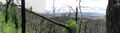
Halfway down we were met by two official logging-looking people driving a mini bulldozer, the one apparently belonging to the trailer. They asked what we were up to, we explained, they said 'Go to the top of the hill, talk to Dr L in the house, and ask his permission.' So we trooped on up to the top of the hill, to a house with stunning 360 degree views of the Yarra Valley wine region, and looking back across the wooded hills of north-east Melbourne. We introduced ourselves to the property owner - a spry older chap - explained what we were doing, and asked his permission to find the hashpoint. He looked bemused, but gave his blessing on the provisor that the dog stayed on leash, and went back to what he was doing. He warned us that there were lyrebirds around - a protected species - hence his request that the dog stay on leash!
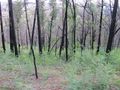
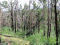
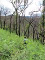
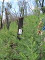
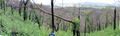
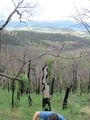
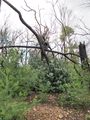
We walked down from the house to the ridge shown on the map, the one that Skyline Road apparently is, taking a direct route rather than walking back to the access path. Along the way, we were surrounded by wattle trees growing back in huge clumps, and the beautiful new green leaves of eucalypts. However, underfoot was ash, charcoal, and the skeletons of burnt trees. Some eucalypt species are fire-activated; the gum nuts that fall from the trees only open in extreme heat such as that in a bushfire. THey also sprout new vegetation within days of a fire, with small buds under the bark putting out sprays of foliage that provide much needed energy to the tree. Even after such an awful event, life springs anew.
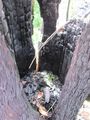
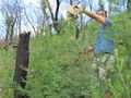
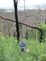
And our enthusiasm sprung anew as my mate, now guiding us to the exact point, said there was under 100m to go. Down a STEEP hill. Through chest-high wattles. On loose gravel, half-degraded charcoal, and past tree stumps. After two days of torrential rain, which churned up the loose soil into clay mud. He lead the way - now barefoot; I'd neglected to mention that flip flops were not the best geohashing footwear - closely followed by the dog, who loved running in amongst the foliage, with me cautiously bringing up the rear. We worked our way down and across the slope progressively, then bingo - down to just 10 metres. We struggled past fallen trees and burnt stumps to reach the final destination - fittingly, about a metre away from a blackened, charred eucalypt stump.
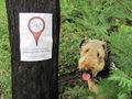
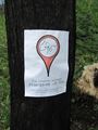
I took the necessary proof photos and hung a hash-marker - printed on recycled paper with biodegradable adhesives - took the photos, and left. I don't feel guilty about leaving potential geotrash, as the paper will degrade quickly in the environment and form part of the forest floor when it's fully broken down.
We staggered back up the hill to the track, and found our way back through to the car, getting back just in time to avoid the rain. Washed our feet quickly, gave the dog a drink - what a trooper - then headed to the Coldstream Brewery for pilsner and lunch. Lunch - a rabbit, mozarella and grape pizza - was appreciated by all, including the dog.
Drove home and got home just in time for the heavens to open once again.
This was a really fun hash, enhanced by the willingness of my mate and the dog to get their feet dirty. Thank you both! And to Dr L for letting us walk through his property!
Tracklog
Photos
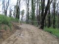
Can't go any further
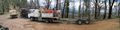
Construction gear
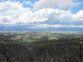
Yarra Valley views
Burnt trees from fires
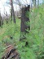
A typical burnt tree stump

This is what Google Maps terms a 'road'
Hashpoint is THATAWAY
Still 200m off
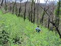
Pack leader goes jungle amongst the wattles
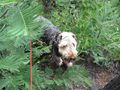
Kozz's dog very happy
Pack leader - tracking down the hashpoint, barefoot!
The hashpoint! Yay!
Looking out from the hashpoint
Perhaps flip flops aren't the best country hashing footwear…
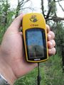
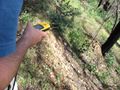
Accuracy only 8m…
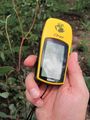
…but still very close now
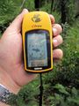
1.26m - we're there!
Kozz's dog at the hashpoint
I FOUNDS IT!
The hashmarker
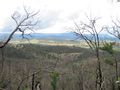
Looking back out across the valley
The hashpoint pano from higher up
Heading back to the top
Looking back over the valley
Beautiful green regrowth all around
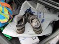
Ewww, hashmud.


.JPG)


