Difference between revisions of "2010-04-05 47 11"
imported>Zb (Created page with '{{subst:Expedition |lat = 47 |lon = 11 |date = 2010-04-05 }}') |
imported>FippeBot m (Location) |
||
| (4 intermediate revisions by 2 users not shown) | |||
| Line 1: | Line 1: | ||
| − | |||
<!-- If you did not specify these parameters in the template, please substitute appropriate things for IMAGE, LAT, LON, and DATE (YYYY-MM-DD format) | <!-- If you did not specify these parameters in the template, please substitute appropriate things for IMAGE, LAT, LON, and DATE (YYYY-MM-DD format) | ||
| Line 15: | Line 14: | ||
__NOTOC__ | __NOTOC__ | ||
== Location == | == Location == | ||
| − | + | South of Tutzing, very close to the railroad tracks from Tutzing to Kochel. | |
== Participants == | == Participants == | ||
| − | + | * [[User:Zb|zb]] | |
== Plans == | == Plans == | ||
| − | + | * I am just starting to make plans to maybe go to the spot by train or bike. It's close to railtracks South of Tutzing. My plans are still very uncertain, as of yet. It'll depend mainly on the weather, I guess, but the forecast is actually not too bad. --[[User:Zb|Zb]] 18:06, 4 April 2010 (UTC)... | |
| + | * Maybe get on the bike around 10 am, be at the coords around 1 pm, back in München around 4:30 pm? Still not sure, but this is what I might be doing... --[[User:Zb|Zb]] 23:10, 4 April 2010 (UTC)... | ||
| + | * Update: Get on the bike around 9 am and see what happens... Maybe stop every 5.0 km along the way and take a picture of whatever is there? --[[User:Zb|Zb]] 05:22, 5 April 2010 (UTC) | ||
| + | |||
| + | == Narrative == | ||
| + | |||
| + | First of all, I am completely blown away by the amazing accuracy and quality of [http://www.openstreetmap.org/?lat=47.87865&lon=11.2557&zoom=16&layers=B000FTF the Open Street Map], without which I probably would have to call this one a failure. | ||
| − | + | Now on to the report: | |
| − | |||
| − | + | I left not at 9 am, but at 10 am (always good to put the extra hour into a plan...), prepared with lots of tea, some sandwiches, no GPS, but map printouts. The route took me through the City of München and then South through the woods until I got to Leutstetten. On to Starnberg (downhill!) and all along the Western shore of Lake Starnberg until I was just South of Tutzing. I took almost the same way back (uphill!), except for a small detour in Starnberg caused by own stupidity and stop at a restaurant in München where I met a friend at 5 pm. | |
| − | + | ||
| + | Despite some huge and mean-looking clouds, the weather never managed to get me really drenched, so this was cool, too. | ||
| + | |||
| + | I remembered to stop and take a picture every time my cheapo bike speedometer showed a multiple of 5.00 km, so the pictures can very well tell the rest of the story. | ||
== Photos == | == Photos == | ||
| − | |||
| − | |||
| − | |||
<gallery perrow="4"> | <gallery perrow="4"> | ||
| + | Image:2010-04-05_47_11_zb_Tutzing_0003.jpg | Our neighbors' cat used all of his super powers to make me stay home, ... | ||
| + | Image:2010-04-05_47_11_zb_Tutzing_0001.jpg | ... but the horse outside the kitchen window looks like it needs to be taken for a ride. (0.00 km) | ||
| + | Image:2010-04-05_47_11_zb_Tutzing_0004.jpg | München's East Cemetery (5.00 km) | ||
| + | Image:2010-04-05_47_11_zb_Tutzing_0005.jpg | München-Thalkirchen. (10.00 km) The point was to take a picture every 5.00 km, no matter if the spot was nice or not. | ||
| + | Image:2010-04-05_47_11_zb_Tutzing_0008.jpg | München-Obersendling (15.00 km) | ||
| + | Image:2010-04-05_47_11_zb_Tutzing_0010.jpg | Road St 2065 (next to Autobahn A95, 20.00 km) | ||
| + | Image:2010-04-05_47_11_zb_Tutzing_0011.jpg | Forstenrieder Park, somewhat South of Buchendorf (25.00 km) | ||
| + | Image:2010-04-05_47_11_zb_Tutzing_0012.jpg | Road St 2063, South of Leutstetten (30.00 km) | ||
| + | Image:2010-04-05_47_11_zb_Tutzing_0013.jpg | The esplanade in Starnberg, overlooking Lake Starnberg. There were many mean-looking people who had obviously no fun at all during their walk (35.00 km). | ||
| + | Image:2010-04-05_47_11_zb_Tutzing_0019.jpg | Leaving Possenhofen to the South (40.00 km) | ||
| + | Image:2010-04-05_47_11_zb_Tutzing_0020.jpg | Arriving in Tutzing (45.00 km) | ||
| + | Image:2010-04-05_47_11_zb_Tutzing_0022.jpg | Between Tutzing an Bernried. Note the boat on the lake, above the bike. Also note the evil-looking clouds. This is where I left road St 2063 to head on into the unknown territories around the coordinates. (50.00 km) | ||
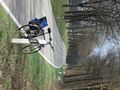
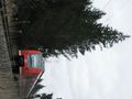
| + | Image:2010-04-05_47_11_zb_Tutzing_0035.jpg | Parking the bike close to the coords. Looks like the ''parking lot'' has just been cleared in preparation for this geohash. (53.26 km) | ||
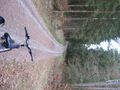
| + | Image:2010-04-05_47_11_zb_Tutzing_0033.jpg | According to the printed map and satellite images I brought along, this must be it. The (very) nearby rail tracks are visible in this picture too, and you can see the open field SW of the coords behind the rail tracks. (''Teh spot!'') | ||
| + | Image:2010-04-05_47_11_zb_Tutzing_0029.jpg | Hanging around the coords for a while to eat lunch, get rained on, watch some birds, ... | ||
| + | Image:2010-04-05_47_11_zb_Tutzing_0027.jpg | ... and, of course, take some pictures of trains. This one passes the location while it goes North to Tutzing. (Class 425) | ||
| + | Image:2010-04-05_47_11_zb_Tutzing_0031.jpg | This one goes South to Kochel. The tall tree is really close to the rail tracks and can be seen on the satellite image, too. (very same 425, the signal is a Bü 0/1) | ||
</gallery> | </gallery> | ||
| + | Pictures of km 60...105 will be added soon... | ||
| + | |||
| + | == Quote of Note == | ||
| + | |||
| + | Overheard at a kiosk close to München's zoo: | ||
| + | |||
| + | Customer: ''How long are you open today?'' | ||
| − | + | Owner: ''Oh, that varies a lot.'' | |
| − | |||
| − | |||
| − | + | I bet having the freedom to say something like this is the dream of everyone working in a store. | |
| − | |||
| − | |||
| − | |||
| − | |||
[[Category:Expeditions]] | [[Category:Expeditions]] | ||
| − | |||
[[Category:Expeditions with photos]] | [[Category:Expeditions with photos]] | ||
| − | |||
[[Category:Expedition without GPS]] | [[Category:Expedition without GPS]] | ||
| − | |||
| − | |||
| − | |||
[[Category:Coordinates reached]] | [[Category:Coordinates reached]] | ||
| − | + | {{location|DE|BY|STA}} | |
| − | |||
| − | |||
| − | |||
| − | |||
| − | |||
| − | |||
| − | |||
| − | |||
| − | |||
Latest revision as of 01:30, 9 August 2019
| Mon 5 Apr 2010 in 47,11: 47.8796675, 11.2561088 geohashing.info google osm bing/os kml crox |
Location
South of Tutzing, very close to the railroad tracks from Tutzing to Kochel.
Participants
Plans
- I am just starting to make plans to maybe go to the spot by train or bike. It's close to railtracks South of Tutzing. My plans are still very uncertain, as of yet. It'll depend mainly on the weather, I guess, but the forecast is actually not too bad. --Zb 18:06, 4 April 2010 (UTC)...
- Maybe get on the bike around 10 am, be at the coords around 1 pm, back in München around 4:30 pm? Still not sure, but this is what I might be doing... --Zb 23:10, 4 April 2010 (UTC)...
- Update: Get on the bike around 9 am and see what happens... Maybe stop every 5.0 km along the way and take a picture of whatever is there? --Zb 05:22, 5 April 2010 (UTC)
Narrative
First of all, I am completely blown away by the amazing accuracy and quality of the Open Street Map, without which I probably would have to call this one a failure.
Now on to the report:
I left not at 9 am, but at 10 am (always good to put the extra hour into a plan...), prepared with lots of tea, some sandwiches, no GPS, but map printouts. The route took me through the City of München and then South through the woods until I got to Leutstetten. On to Starnberg (downhill!) and all along the Western shore of Lake Starnberg until I was just South of Tutzing. I took almost the same way back (uphill!), except for a small detour in Starnberg caused by own stupidity and stop at a restaurant in München where I met a friend at 5 pm.
Despite some huge and mean-looking clouds, the weather never managed to get me really drenched, so this was cool, too.
I remembered to stop and take a picture every time my cheapo bike speedometer showed a multiple of 5.00 km, so the pictures can very well tell the rest of the story.
Photos

Our neighbors' cat used all of his super powers to make me stay home, ...
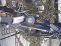
... but the horse outside the kitchen window looks like it needs to be taken for a ride. (0.00 km)
München's East Cemetery (5.00 km)
München-Thalkirchen. (10.00 km) The point was to take a picture every 5.00 km, no matter if the spot was nice or not.
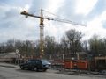
München-Obersendling (15.00 km)
Road St 2065 (next to Autobahn A95, 20.00 km)
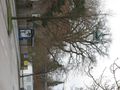
Forstenrieder Park, somewhat South of Buchendorf (25.00 km)
Road St 2063, South of Leutstetten (30.00 km)
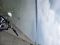
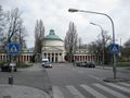
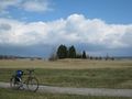
The esplanade in Starnberg, overlooking Lake Starnberg. There were many mean-looking people who had obviously no fun at all during their walk (35.00 km).
Leaving Possenhofen to the South (40.00 km)
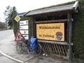
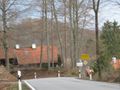
Arriving in Tutzing (45.00 km)
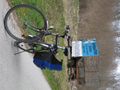
Between Tutzing an Bernried. Note the boat on the lake, above the bike. Also note the evil-looking clouds. This is where I left road St 2063 to head on into the unknown territories around the coordinates. (50.00 km)
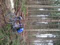
Parking the bike close to the coords. Looks like the parking lot has just been cleared in preparation for this geohash. (53.26 km)
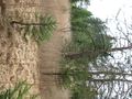
According to the printed map and satellite images I brought along, this must be it. The (very) nearby rail tracks are visible in this picture too, and you can see the open field SW of the coords behind the rail tracks. (Teh spot!)
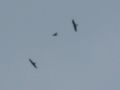
Hanging around the coords for a while to eat lunch, get rained on, watch some birds, ...
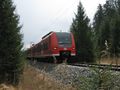
... and, of course, take some pictures of trains. This one passes the location while it goes North to Tutzing. (Class 425)
This one goes South to Kochel. The tall tree is really close to the rail tracks and can be seen on the satellite image, too. (very same 425, the signal is a Bü 0/1)


Pictures of km 60...105 will be added soon...
Quote of Note
Overheard at a kiosk close to München's zoo:
Customer: How long are you open today?
Owner: Oh, that varies a lot.
I bet having the freedom to say something like this is the dream of everyone working in a store.