Difference between revisions of "2010-04-06 60 10"
imported>Relet (a live expedition message sent via geohashdroid for android.) |
m (2020-01-01 update) |
||
| (14 intermediate revisions by 2 users not shown) | |||
| Line 1: | Line 1: | ||
| − | |||
<!-- If you did not specify these parameters in the template, please substitute appropriate things for IMAGE, LAT, LON, and DATE (YYYY-MM-DD format) | <!-- If you did not specify these parameters in the template, please substitute appropriate things for IMAGE, LAT, LON, and DATE (YYYY-MM-DD format) | ||
| Line 26: | Line 25: | ||
<!-- how it all turned out. your narrative goes here. --> | <!-- how it all turned out. your narrative goes here. --> | ||
| + | |||
| + | *It says 7.1km. And the map shows something like a track. I guess I'll have to go and take a look. -- [[User:relet|relet]] 16:13, 05 April 2010 (MESZ) | ||
| + | |||
| + | *I am near. 400m, and this time, there is a hiking path. -- [[User:relet|relet]] [http://www.openstreetmap.org/?lat=60.210946798324585&lon=10.197597742080688&zoom=16&layers=B000FTF @60.2109,10.1976] 17:43, 06 April 2010 (MESZ) | ||
| + | |||
| + | *Crossing undersnow brooks, of course. Ducksocks! -- [[User:relet|relet]] [http://www.openstreetmap.org/?lat=60.210946798324585&lon=10.197597742080688&zoom=16&layers=B000FTF @60.2109,10.1976] 17:50, 06 April 2010 (MESZ) | ||
| + | |||
| + | *I can understand how religions can form around things like a big rock - or in my case: a big stick. I made 50m of progress. -- [[User:relet|relet]] [http://www.openstreetmap.org/?lat=60.210957527160645&lon=10.196288824081421&zoom=16&layers=B000FTF @60.2110,10.1963] 18:09, 06 April 2010 (MESZ) | ||
| + | |||
| + | *We learned in school that water always chooses the easiest path: this tells the intrepid geohasher that HE shouldn't. -- [[User:relet|relet]] [http://www.openstreetmap.org/?lat=60.21151006221771&lon=10.194132328033447&zoom=16&layers=B000FTF @60.2115,10.1941] 18:32, 06 April 2010 (MESZ) | ||
| + | |||
| + | *45! I feel widified. -- [[User:relet|relet]] [http://www.openstreetmap.org/?lat=60.21149396896362&lon=10.191342830657959&zoom=16&layers=B000FTF @60.2115,10.1913] 18:47, 06 April 2010 (MESZ) | ||
| + | |||
| + | *Coordinates reached! Woo! -- [[User:relet|relet]] [http://www.openstreetmap.org/?lat=60.21181583404541&lon=10.191015601158142&zoom=16&layers=B000FTF @60.2118,10.1910] 18:54, 06 April 2010 (MESZ) | ||
| + | |||
| + | *The way back was surprisingly easy. Stick got stuck at about the place I found him. I think he meant to stay. And now for the somewhat annoying cycling home in wet shoes part. I call it the Nordic Triathlon. -- [[User:relet|relet]] [http://www.openstreetmap.org/?lat=60.21181583404541&lon=10.191015601158142&zoom=16&layers=B000FTF @60.2118,10.1910] 19:23, 06 April 2010 (MESZ) | ||
| + | |||
| + | *Phew. I deserve me a pizza. -- [[User:relet|relet]] [http://www.openstreetmap.org/?lat=60.15044152736664&lon=10.25575876235962&zoom=16&layers=B000FTF @60.1504,10.2558] 20:00, 06 April 2010 (MESZ) | ||
== Tracklog == | == Tracklog == | ||
<!-- if your GPS device keeps a log, you may post a link here --> | <!-- if your GPS device keeps a log, you may post a link here --> | ||
| + | |||
| + | == Videos == | ||
| + | |||
| + | [http://www.youtube.com/watch?v=y04CsYeTyUA This is how you identify a brook below the snow.] (Turn on your speakers!) | ||
== Photos == | == Photos == | ||
| Line 34: | Line 55: | ||
--> | --> | ||
<gallery perrow="4"> | <gallery perrow="4"> | ||
| + | File:2010-04-06-60-10-P1050882.JPG | It's all about wood: Norske Skog. | ||
| + | File:2010-04-06-60-10-P1050883.JPG | This looks as if it is going to get just as wet as the other day. | ||
| + | File:2010-04-06-60-10-P1050884.JPG | Yay! It's a hiking path, right to the hash! | ||
| + | File:2010-04-06-60-10-P1050885.JPG | Yay! That's what a hiking path looks like in winter. | ||
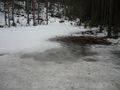
| + | File:2010-04-06-60-10-P1050886.JPG | There is one river hidden in this picture. | ||
| + | File:2010-04-06-60-10-P1050887.JPG | I proceeded in very small steps. | ||
| + | File:2010-04-06-60-10-P1050890.JPG | ..just to meet the next bigger river. | ||
| + | File:2010-04-06-60-10-P1050891.JPG | You should not have tried to step on this bit (which is shown in the smashed-with-a-big-stick state) | ||
| + | File:2010-04-06-60-10-P1050892.JPG | River forded - hooray! | ||
| + | File:2010-04-06-60-10-P1050893.JPG | Elg! | ||
| + | File:2010-04-06-60-10-P1050896.JPG | Eventually, coordinates were reached. | ||
| + | File:2010-04-06-60-10-P1050897.JPG | Tired grin, with Stick in the background. | ||
| + | File:2010-04-06-60-10-P1050908.JPG | If it weren't for the trees and stitching failures, I would have shown you a panorama of this. | ||
| + | File:2010-04-06-60-10-P1050915.JPG | My snow is this deep. | ||
| + | File:2010-04-06-60-10-P1050917.JPG | My shoe is this wet. | ||
| + | File:2010-04-06-60-10-P1050918.JPG | The only sane person in this expedition, Trusty waited for me next to the road. | ||
</gallery> | </gallery> | ||
| − | |||
| − | |||
| − | |||
| − | |||
| − | |||
| − | |||
| − | |||
| − | |||
| − | |||
| − | |||
[[Category:Expeditions]] | [[Category:Expeditions]] | ||
| − | |||
[[Category:Expeditions with photos]] | [[Category:Expeditions with photos]] | ||
[[Category:Expeditions with videos]] | [[Category:Expeditions with videos]] | ||
| − | + | ||
| − | |||
| − | |||
[[Category:Coordinates reached]] | [[Category:Coordinates reached]] | ||
| − | + | {{location|NO|30}} | |
| − | |||
| − | |||
| − | |||
| − | |||
| − | |||
| − | |||
| − | |||
| − | |||
| − | |||
Latest revision as of 00:25, 16 February 2020
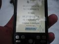
| Tue 6 Apr 2010 in 60,10: 60.2117945, 10.1908889 geohashing.info google osm bing/os kml crox |
Location
Participants
Plans
Expedition
- It says 7.1km. And the map shows something like a track. I guess I'll have to go and take a look. -- relet 16:13, 05 April 2010 (MESZ)
- I am near. 400m, and this time, there is a hiking path. -- relet @60.2109,10.1976 17:43, 06 April 2010 (MESZ)
- Crossing undersnow brooks, of course. Ducksocks! -- relet @60.2109,10.1976 17:50, 06 April 2010 (MESZ)
- I can understand how religions can form around things like a big rock - or in my case: a big stick. I made 50m of progress. -- relet @60.2110,10.1963 18:09, 06 April 2010 (MESZ)
- We learned in school that water always chooses the easiest path: this tells the intrepid geohasher that HE shouldn't. -- relet @60.2115,10.1941 18:32, 06 April 2010 (MESZ)
- 45! I feel widified. -- relet @60.2115,10.1913 18:47, 06 April 2010 (MESZ)
- Coordinates reached! Woo! -- relet @60.2118,10.1910 18:54, 06 April 2010 (MESZ)
- The way back was surprisingly easy. Stick got stuck at about the place I found him. I think he meant to stay. And now for the somewhat annoying cycling home in wet shoes part. I call it the Nordic Triathlon. -- relet @60.2118,10.1910 19:23, 06 April 2010 (MESZ)
- Phew. I deserve me a pizza. -- relet @60.1504,10.2558 20:00, 06 April 2010 (MESZ)
Tracklog
Videos
This is how you identify a brook below the snow. (Turn on your speakers!)
Photos
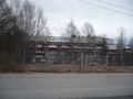
It's all about wood: Norske Skog.
This looks as if it is going to get just as wet as the other day.
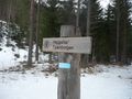
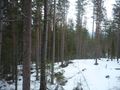
Yay! It's a hiking path, right to the hash!
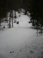
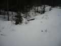
Yay! That's what a hiking path looks like in winter.
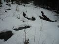
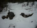
There is one river hidden in this picture.
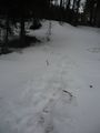
I proceeded in very small steps.
..just to meet the next bigger river.
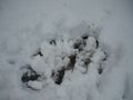
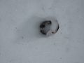
You should not have tried to step on this bit (which is shown in the smashed-with-a-big-stick state)
River forded - hooray!
Elg!
Eventually, coordinates were reached.
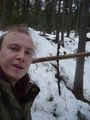
Tired grin, with Stick in the background.
If it weren't for the trees and stitching failures, I would have shown you a panorama of this.
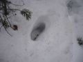
My snow is this deep.
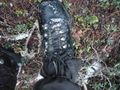
My shoe is this wet.

The only sane person in this expedition, Trusty waited for me next to the road.


