Difference between revisions of "2010-04-11 45 -122"
imported>Michael5000 m (→Expedition5000) |
imported>Jiml (Move participant around) |
||
| Line 1: | Line 1: | ||
| − | |||
| − | |||
| − | |||
| − | |||
| − | |||
| − | |||
{{meetup graticule | {{meetup graticule | ||
| lat=45 | | lat=45 | ||
| Line 17: | Line 11: | ||
== Participants == | == Participants == | ||
| − | + | ||
| Line 25: | Line 19: | ||
== Plans == | == Plans == | ||
| − | Elegant Forkbomb | + | * [[User:Elegant Forkbomb|Elegant Forkbomb]] was going to give it a shot. He'll be travelling from PSU by bike, planning to arrive at the hashpoint at around 1pm. |
| − | + | :Sounds like plans got cancelled... | |
| − | The 5000s aren't much of planners. | + | * The 5000s aren't much of planners. |
| − | + | :But, they went! | |
== Expedition == | == Expedition == | ||
Revision as of 03:50, 15 April 2010
| Sun 11 Apr 2010 in 45,-122: 45.2997107, -122.5633684 geohashing.info google osm bing/os kml crox |
Location
In a small swamp near Stone Creek Golf Course south of Oregon City.
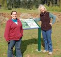
Participants
- Michael5000
- Mrs.5000
- Rebel
Plans
- Elegant Forkbomb was going to give it a shot. He'll be travelling from PSU by bike, planning to arrive at the hashpoint at around 1pm.
- Sounds like plans got cancelled...
- The 5000s aren't much of planners.
- But, they went!
Expedition
Expedition5000
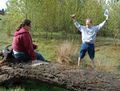
Michael5000 asked Mrs.5000 if she was up for a hash, and she agreed immediately. While filling the truck at the corner gas station, they observed Rebel coming down the street. "We're going geohashing!" they said. "Want to come?" "I totally do," responded Rebel, and the three of them scrunched into the cab of the truck.
The aerial image of the hashpoint was a little mysterious, with an odd rectangular structure (a shed?), a linear feature, and some kind of light-colored swath to the east, near the road. While approaching the site on highway 213, the meaning of the swath became clear -- there is a welcoming walking path that runs all around the golf course. This made access to the hash area unusually convenient.
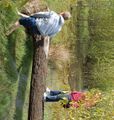
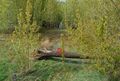
The rectangle turned out to be a culvert underneath the highway, which was fine except that it was carrying a vigorous little stream into the area. The hash itself was just beyond a fallen tree -- the linear feature -- in about six inches of standing water. Rebel clambered out on the log while Michael5000 waded in (after reassuring himself that he's not in a graticule where schistosomiasis is a real concern) and planted the expedition flag.
After consulting the literature, Michael5000 decided he doesn't really qualify for the Water Geohash Achievement.
Photos
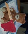
Our hashcot prepares the Expedition flag
Rebel & Mrs.5000
Michael5000 and Rebel approach the hashpoint
The hashpoint is reached

The flag is planted
View of the hashpoint
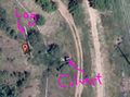
Aerial image of the hashpoint


