Difference between revisions of "2010-06-02 35 -80"
imported>Ramblingwreck (→Plans) |
imported>FippeBot m (Location) |
||
| (8 intermediate revisions by 2 users not shown) | |||
| Line 1: | Line 1: | ||
| − | |||
| − | |||
| − | |||
| − | |||
| − | |||
| − | |||
| − | |||
{{meetup graticule | {{meetup graticule | ||
| lat=35 | | lat=35 | ||
| Line 31: | Line 24: | ||
== Expedition == | == Expedition == | ||
<!-- how it all turned out. your narrative goes here. --> | <!-- how it all turned out. your narrative goes here. --> | ||
| + | |||
| + | I left work shortly before 6:00. Before I left the parking lot, I programmed Black Star with the appropriate coordinates and set off. Google Maps would not be needed for this expedition as it was only one turn off of a major road. | ||
| + | |||
| + | [[File:200-06-02 35 -80 Pic2.jpg | thumb|right |Pictured: Challenge]] | ||
| + | As I arrived at the hashzone and turned into the parking lot, I noticed something that suddenly made the trip alot more interesting. A speed limit sign. Normal people see speed limit signs as obstacles. Geohashers see them as opportunities. As I cruised past the spot I knew the point to be, I checked Black Star and confirmed that the point was less than 10 meters from the road. I would go back and get my [[speed racer achievement]] last, on the way out. | ||
| + | |||
| + | I parked my car and strolled over to the point, making sure to get as close as possible. I took a couple pictures and left my marker while cautiously watching the darkening skies. This was by far the easiest hashpoint I've ever achieved. | ||
| + | |||
| + | After a few peals of thunder, I returned to the car and prepared to drive by the hashpoint. That's when I realized I had a little problem. The speed limit was 10 miles per hour, but BlackStar reported my speed in kilometers per hour. I knew that 1 kilometer was about 0.62 miles, so I estimated that I'd be shooting for somewhere between 15 and 16 kph (true value 16.1kph). I probably could have got out the calculator and found out for sure, but after working all day I didn't feel much like it. At any rate, I made a couple passes getting screen captures from BlackStar. Neither was perfect, but I submit my achievement application along with available evidence in hopes that it is deemed sufficient. | ||
| + | |||
| + | It turned out to be a good move to get the hashpoint pictures first and the achievement second, because by the time I pulled out of the parking lot, rain was falling in sheets. A short drive later, I was home. | ||
| + | |||
| + | I must admit, this hashpoint provides me with much less of a sense of accomplishment than my previous expeditions. It was just too easy. In retrospect, it would have made a great bicycle geohash. I'm going to have to get a bicycle. | ||
== Tracklog == | == Tracklog == | ||
<!-- if your GPS device keeps a log, you may post a link here --> | <!-- if your GPS device keeps a log, you may post a link here --> | ||
| + | |||
| + | Tracklog for your viewing pleasure | ||
| + | |||
| + | http://www.instamapper.com/trk?key=12571385405299595303 | ||
== Photos == | == Photos == | ||
| Line 39: | Line 49: | ||
Image:2009-##-## ## ## Alpha.jpg | Witty Comment | Image:2009-##-## ## ## Alpha.jpg | Witty Comment | ||
--> | --> | ||
| − | <gallery perrow=" | + | <gallery perrow="4"> |
| + | Image:2010-06-02 35 -81 Proof.jpg | Obligatory proof. | ||
| + | Image:2010-06-02 35 -80 Grin.jpg | Obligatory grin. | ||
| + | Image:2010-06-02 35 -80 Pic1.jpg | Picture from the hashpoint. | ||
| + | Image:2010-06-02 35 -81 Marker.jpg | The Internet was here. | ||
| + | Image:2010-06-02 35 -80 Speed1.jpg | Proof of achievement exhibit A | ||
| + | Image:2010-06-02 35 -80 Speed2.jpg | Proof of achievement exhibit B | ||
</gallery> | </gallery> | ||
| Line 46: | Line 62: | ||
<!-- Add any achievement ribbons you earned below, or remove this section --> | <!-- Add any achievement ribbons you earned below, or remove this section --> | ||
| + | {{Speed racer | ||
| + | | latitude = 35 | ||
| + | | longitude = -80 | ||
| + | | date = 2010-06-02 | ||
| + | | name = Art | ||
| + | | speed = 10 mph | ||
| + | }} | ||
| − | |||
| − | |||
| − | |||
| − | |||
| − | |||
| − | |||
| − | |||
| − | |||
| − | |||
| − | |||
[[Category:Expeditions]] | [[Category:Expeditions]] | ||
| − | |||
[[Category:Expeditions with photos]] | [[Category:Expeditions with photos]] | ||
| − | + | ||
[[Category:Expedition without GPS]] | [[Category:Expedition without GPS]] | ||
| − | + | ||
| − | + | ||
[[Category:Coordinates reached]] | [[Category:Coordinates reached]] | ||
| − | + | {{location|US|NC|MB}} | |
| − | |||
| − | |||
| − | |||
| − | |||
| − | |||
| − | |||
| − | |||
| − | |||
| − | |||
Latest revision as of 02:16, 9 August 2019
| Wed 2 Jun 2010 in 35,-80: 35.2445462, -80.9830223 geohashing.info google osm bing/os kml crox |
Location
In an industrial park in western Charlotte
Participants
Plans
I would drive to the hashpoint after work as it was easily accessible.
Expedition
I left work shortly before 6:00. Before I left the parking lot, I programmed Black Star with the appropriate coordinates and set off. Google Maps would not be needed for this expedition as it was only one turn off of a major road.

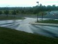
As I arrived at the hashzone and turned into the parking lot, I noticed something that suddenly made the trip alot more interesting. A speed limit sign. Normal people see speed limit signs as obstacles. Geohashers see them as opportunities. As I cruised past the spot I knew the point to be, I checked Black Star and confirmed that the point was less than 10 meters from the road. I would go back and get my speed racer achievement last, on the way out.
I parked my car and strolled over to the point, making sure to get as close as possible. I took a couple pictures and left my marker while cautiously watching the darkening skies. This was by far the easiest hashpoint I've ever achieved.
After a few peals of thunder, I returned to the car and prepared to drive by the hashpoint. That's when I realized I had a little problem. The speed limit was 10 miles per hour, but BlackStar reported my speed in kilometers per hour. I knew that 1 kilometer was about 0.62 miles, so I estimated that I'd be shooting for somewhere between 15 and 16 kph (true value 16.1kph). I probably could have got out the calculator and found out for sure, but after working all day I didn't feel much like it. At any rate, I made a couple passes getting screen captures from BlackStar. Neither was perfect, but I submit my achievement application along with available evidence in hopes that it is deemed sufficient.
It turned out to be a good move to get the hashpoint pictures first and the achievement second, because by the time I pulled out of the parking lot, rain was falling in sheets. A short drive later, I was home.
I must admit, this hashpoint provides me with much less of a sense of accomplishment than my previous expeditions. It was just too easy. In retrospect, it would have made a great bicycle geohash. I'm going to have to get a bicycle.
Tracklog
Tracklog for your viewing pleasure
http://www.instamapper.com/trk?key=12571385405299595303
Photos

Obligatory proof.

Obligatory grin.
Picture from the hashpoint.
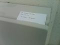
The Internet was here.

Proof of achievement exhibit A
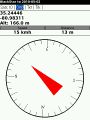
Proof of achievement exhibit B


Achievements
