2010-06-20 60 9
| Sun 20 Jun 2010 in 60,9: 60.6670247, 9.1929691 geohashing.info google osm bing/os kml crox |
Contents
Location
East of Gol, near Vardefjell.
Participants
Plans
Since it is the weekend, I thought I might as well go expeditioning. And since that graticule is still on my list, I don't even have to venture far.
- Trains to Gol on Saturday: 8:13, 9:38, 12:22, duration 1:30.
- Walking distance: ca. 15km.
- Trains back on Sunday: 11:41, 14:23, 19:38, 20:28
Still hoping that the weather gets a bit more interesting than just now.
Expedition
before
after


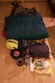
Packing list
things actually brought (due to planning)
- sleeping bag
- tarp
- mosquito net
- five tent pegs
- cooker
- gas
- mattress
- tape
- a Swiss tool
- a spoon (like a spork, but without fork)
- cookable food
- non-cooking food
- water bottles
- plastic bags
- kitchen paper
- camera equipment
- spare phone battery
- hiking poles
- phone/GPS
things remembered just before cycling away
- matches
things to remember next time
- a lid for the pot
- hiking boots
- sunglasses
- a hat
- actually charge the second phone battery
- a map of the area
- coordinates
things tempting me to be brought along
- the raft that had arrived in the mail the morning I left
Day 1
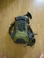
So, the weather report turned out to be alright (or outright sunny), and since I had brought lots of outdoor equipment from home and it was the weekend, I think there was little that could make me not geohashing. The backpack was packed already on the evening before. As you can see, I brought all the necessary things to reach an outdoor geohash in unmarked terrain. By definition, everything else is unneccessary weight, isn't it? It still took me a good while to get up in the morning, so that I settled for the 12:22 train indeed. I cycled to the train station...
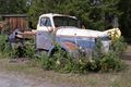
This wagon has a quad propeller turbo booster.

...where I comforted myself into an amazingly spacious (as I realized on the return trip) 'comfort wagon' of Bergensbanen. It did not seem to be something like 'first class' or the like, since they did not charge me more. In the train, I started to consider live logging my expedition. But what was that? Despite having good signal, the Internet was gone! I settled for looking out of the window instead. I don't know where or when I realized that the only way to get the coordinates was to go online. I hoped that I would be able to fix the connection problems eventually, when I was no longer in a moving train.
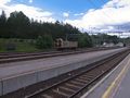
After reaching Gol station, I set out on foot, along the river and using some of the maps I had fortunately cached in one of my (non-geohashing) android apps. Knowing that I had not remembered to recharge the second phone battery, which therefore was of dubious quality, and not having uplink anyway, I switched to airplane mode for most of the time, only turning on GPS signal once in a while to confirm I was on the right track.
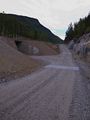
The first decision to take was whether I would follow the main road from the station to the mountains, or a small track on the other side of the river and the railway line. I decided for the latter, as my map tiles showed me both a railway crossing and a bridge near where I wanted to go. Now I know from an authoritative source (I happen to work at the mapping authority) that the tiles I downloaded were from 2008 and from previous experience that the course of roads changes easily during a hectic Norwegian summer of construction. Hence, I was only mildly surprised, when the level crossing I expected had a fence on both sides, the catwalk over the neighboring ditch was broken, and the signage unimpressedly told you to look out for trains when crossing there. I could even see a path on the other side descending straight towards the bridge. Fortunately, a solution was soon found
The level crossing (for experienced trainspotters only).
Why the crossing was fenced - an underpass 600m further down the road.
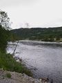
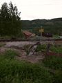
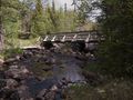
The river to cross...
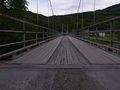
...and a bridge to cross it with.


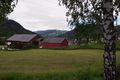
The roads I followed were tarmaced at first, but I knew from past hikes that they would soon enough end at a toll station and continue as privately maintained mountain track. I enjoyed...
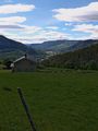
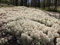
Mountain views,
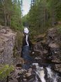
Waterfalls,
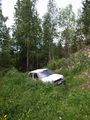
Parking lots,
More mountain views,
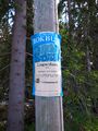
The local library,
Old machines,
and nature in general.


I reached the toll station (I told you there would be a toll station) at about the time where my maps indicated that I should disgress from the road onto a "minor path of vehicle width", which usually means a ski run. There was no such thing crossing the road. However, I heard a lawnmower nearby, and went to ask the friendly lawnmower driver for help. He was obviously confused by the map I showed him (phone screens are not really good for the overall orientation, if you do not zoom and pan around), but told me there was a ski run right behind his house and that I could just walk through a gap in his fence. And indeed, that one was pointing in the right direction. I had a short chat with his two girls, who seemed to be building a ski ramp for winter (or something out of wood that looks like a small ski jump) in the backyard, which, due to my restricted knowledge of the Norwegian language went like this:
- "Hi, where are you going?"
- Me: "I don't know... to the mountains."
- "Good luck!".
- Me: "Are you building a ski-uhm?"
- "Yes."
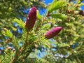
That did not really help me figure out what it was. I should have asked them if I can take a picture. On the way, I enjoyed...
Bridges.
Amazing moss.
Rocks.
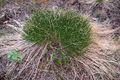
And more nature.


Now, ski runs may be as wide as a vehicle (the one that lays the tracks, usually), but they are not specifically required to be walkable when there is no snow. Hence, the quality of the path switched from dry to muddy to dry to in the middle of a swamp. It took me several hours to cross that bit, hopping from one largely dry bush to another, balancing over stones, and crossing the worst part (and a river along the way) bare footed. Fortunately, the sun was out, so that I could stop on the odd rock to re-heat my feet. And I do love my hiking poles, which made the balancing parts a lot easier (and the climbing and downhill parts too).
The river I would eventually have to cross

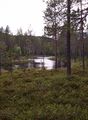
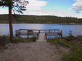
Eventually reaching the other end of the ski run, I was back on mountain tracks again. For the first (and the last) time I saw two people, which were fishing near their hut in a mountain lake. It also had this cozy bridge/jetty.
Yay!

This was also about the time I realized that my Internets would not just magically reappear, and I decided to text for help. (Reception was fine. As I realized later, it was just a runaway dash that has appeared in my access point settings) According to my logs, that was 18:20, which means I had been walking for about four hours now. The Danatar service quickly replied with the coordinates and a rough localization. Woo for Internet by Proxy! My journey went further along another mountain track, where I decided to take a break.
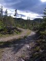
Mountain tracks.

My tortilla face.


Day 2
...
- Coordinates reached! Everything else follows. I am currently sitting Nesbyen station waiting for the evening train, after having barely missed the afternoon one. -- relet @60,5762,9,1068 17:19, 20 Juni 2010 (MESZ)
Achievements
relet earned the Midnight Geohash achievement
|
relet earned the Camping geohash achievement
|
relet earned the Picnic achievement
|
This user loves Mother Nature
|
Danatar earned the Gentleman's Achievement
|