Difference between revisions of "2010-06-23 45 -122"
imported>Jiml (Complete report) |
imported>FippeBot m (Location) |
||
| (One intermediate revision by one other user not shown) | |||
| Line 1: | Line 1: | ||
| − | |||
| − | |||
| − | |||
| − | |||
| − | |||
| − | |||
{{meetup graticule | {{meetup graticule | ||
| lat=45 | | lat=45 | ||
| Line 14: | Line 8: | ||
__NOTOC__ | __NOTOC__ | ||
== Location == | == Location == | ||
| − | The | + | The backyard of a home in Hillsdale, Oregon |
== Participants == | == Participants == | ||
| Line 20: | Line 14: | ||
== Plans == | == Plans == | ||
| − | Both hashpoints appeared possible today, so I figured I'd try for | + | Both hashpoints appeared possible today, so I figured I'd try for a multihash! |
== Expedition == | == Expedition == | ||
| − | I | + | I went for this point first since I expected I might need permission to get |
| − | a picture. | + | to it, and it would be easier to get that earlier rather than later. |
| + | |||
| + | I found my way to the street, and watched the GPS as I climbed the hill, parking when I | ||
| + | got close. A little back and forth in the road betwen the two houses | ||
| + | showed that it appeared to be in the backyard of the first one, so I went up to to the | ||
| + | door to ask for permission to enter the backyard. I easily got it, went into the yard, found | ||
| + | the hashpoint and took | ||
| + | a picture. | ||
| + | |||
| + | Then I headed off to the [[2010-06-23 45 -123|Tillamook Forest.]] | ||
| Line 69: | Line 72: | ||
[[Category:Expeditions with photos]] | [[Category:Expeditions with photos]] | ||
[[Category:Coordinates reached]] | [[Category:Coordinates reached]] | ||
| + | {{location|US|OR|MU}} | ||
Latest revision as of 02:30, 9 August 2019
| Wed 23 Jun 2010 in 45,-122: 45.4826269, -122.6964737 geohashing.info google osm bing/os kml crox |
Location
The backyard of a home in Hillsdale, Oregon
Participants
Plans
Both hashpoints appeared possible today, so I figured I'd try for a multihash!
Expedition
I went for this point first since I expected I might need permission to get to it, and it would be easier to get that earlier rather than later.
I found my way to the street, and watched the GPS as I climbed the hill, parking when I got close. A little back and forth in the road betwen the two houses showed that it appeared to be in the backyard of the first one, so I went up to to the door to ask for permission to enter the backyard. I easily got it, went into the yard, found the hashpoint and took a picture.
Then I headed off to the Tillamook Forest.
Photos

The GPS at the hashpoint - Hashbush in the background
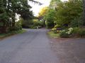
Up the hill from the hashpoint's house
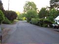
Down the hill from the hashpoint's house


Achievements
Jim earned the Land geohash achievement
|
Jim earned the Ambassador achievement
|
Jim earned the Multihash Achievement
|