Difference between revisions of "2010-07-01 43 -88"
imported>Bassoon (Created page with '{{subst:Expedition |lat = 43 |lon = -89 |date = 2010-07-01 }}') |
imported>FippeBot m (Location) |
||
| (One intermediate revision by one other user not shown) | |||
| Line 1: | Line 1: | ||
| − | |||
| − | |||
| − | |||
| − | |||
| − | |||
| − | |||
| − | |||
{{meetup graticule | {{meetup graticule | ||
| lat=43 | | lat=43 | ||
| − | | lon=- | + | | lon=-88 |
| date=2010-07-01 | | date=2010-07-01 | ||
}} | }} | ||
| − | |||
| − | |||
== Location == | == Location == | ||
| − | + | In a field just off the road in Hubertus, Wisconsin. | |
== Participants == | == Participants == | ||
| − | + | *[[User:Bassoon|Bassoon]] | |
| + | *[[User:Dedehawk|Dedehawk]] | ||
== Plans == | == Plans == | ||
| − | + | Both Dedehawk and Bassoon had plans to attend a concert which was scheduled shortly after the geohashing excursion, so it was going to be a quick geohash. It wouldn't take more than a half hour, at most. | |
== Expedition == | == Expedition == | ||
| − | + | It all went pretty well. We drove out to the geohash and had an argument with the GPS and then headed about 15 feet into the field (where there were no posted "No Trespassing" signs) and then took photos of verification and whatnot. While in the field, Dedehawk found a golf ball and took it away, possibly procuring a Geotrash Geohash achievement. After that, we headed back to a Citgo to stop and see if they sold Squishies. Alas, they did not, but Bassoon obtained gummi worms instead. Overall, we decided that if the geohash wasn't within 15 feet of the road and it also fell into a field, then we'd just give up for that day, as we didn't want to trample too many crops. | |
| − | |||
| − | |||
| − | |||
== Photos == | == Photos == | ||
| − | |||
| − | |||
| − | |||
<gallery perrow="5"> | <gallery perrow="5"> | ||
| + | Image:2010-07-01 43 -88 bassoon-hates-gps.png | Bassoon hates his freaking GPS. | ||
| + | Image:2010-07-01 43 -88 dedehawk-fieldwalker.png | Dedehawk walks the fields in search of the geohash. | ||
| + | Image:2010-07-01 43 -88 verification-shot-gps.png | We did it! Yay! | ||
| + | Image:2010-07-01 43 -88 dedehawk-trashball.png | Dedehawk found a golf ball. It's trash when in a field, isn't it? | ||
</gallery> | </gallery> | ||
== Achievements == | == Achievements == | ||
{{#vardefine:ribbonwidth|800px}} | {{#vardefine:ribbonwidth|800px}} | ||
| − | + | {{land geohash | |
| − | + | | latitude = 43 | |
| − | + | | longitude = -88 | |
| − | + | | date = 2010-07-01 | |
| − | + | | name = Bassoon and Dedehawk | |
| − | + | | image = 2010-07-01 43 -88 verification-shot-gps.png | |
| − | + | }} | |
| − | + | {{Geotrash | |
| − | + | | latitude = 43 | |
| − | + | | longitude = -88 | |
| − | -- | + | | date = 2010-07-01 |
| − | + | | name = Dedehawk | |
| − | + | | image = 2010-07-01 43 -88 dedehawk-trashball.png | |
| + | }} | ||
[[Category:Expeditions]] | [[Category:Expeditions]] | ||
| − | |||
[[Category:Expeditions with photos]] | [[Category:Expeditions with photos]] | ||
| − | + | ||
| − | |||
| − | |||
| − | |||
| − | |||
[[Category:Coordinates reached]] | [[Category:Coordinates reached]] | ||
| − | + | {{location|US|WI|WN}} | |
| − | |||
| − | |||
| − | |||
| − | |||
| − | |||
| − | |||
| − | |||
| − | |||
| − | |||
Latest revision as of 02:35, 9 August 2019
| Thu 1 Jul 2010 in 43,-88: 43.2381376, -88.1819624 geohashing.info google osm bing/os kml crox |
Location
In a field just off the road in Hubertus, Wisconsin.
Participants
Plans
Both Dedehawk and Bassoon had plans to attend a concert which was scheduled shortly after the geohashing excursion, so it was going to be a quick geohash. It wouldn't take more than a half hour, at most.
Expedition
It all went pretty well. We drove out to the geohash and had an argument with the GPS and then headed about 15 feet into the field (where there were no posted "No Trespassing" signs) and then took photos of verification and whatnot. While in the field, Dedehawk found a golf ball and took it away, possibly procuring a Geotrash Geohash achievement. After that, we headed back to a Citgo to stop and see if they sold Squishies. Alas, they did not, but Bassoon obtained gummi worms instead. Overall, we decided that if the geohash wasn't within 15 feet of the road and it also fell into a field, then we'd just give up for that day, as we didn't want to trample too many crops.
Photos
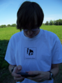
Bassoon hates his freaking GPS.
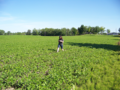
Dedehawk walks the fields in search of the geohash.
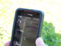
We did it! Yay!

Dedehawk found a golf ball. It's trash when in a field, isn't it?


Achievements
Bassoon and Dedehawk earned the Land geohash achievement
|
Dedehawk earned the GeoTrash Geohash Achievement
|