Difference between revisions of "2010-07-11 48 -122"
imported>Robyn (Wade & Robyn were here.) |
imported>FippeBot m (Location) |
||
| (6 intermediate revisions by 2 users not shown) | |||
| Line 1: | Line 1: | ||
| − | Wade & Robyn | + | {{meetup graticule |
| + | | lat=48 | ||
| + | | lon=-122 | ||
| + | | date=2010-07-11 | ||
| + | }} | ||
| + | |||
| + | <!-- edit as necessary --> | ||
| + | __NOTOC__ | ||
| + | == Location == | ||
| + | At the end of a dead end road in Arlington. | ||
| + | |||
| + | == Participants == | ||
| + | *[[User:Wade|Wade]] | ||
| + | *[[User:Robyn|Robyn]] & T-Rex, because he was in the car | ||
| + | |||
| + | == Plans == | ||
| + | Swing by as a brief detour on the way home from rafting in Skykomish. | ||
| + | |||
| + | == Expedition == | ||
| + | A very simple geohash. We took the 172nd Street exit from I-5 in Arlington and turned left and right and left and right and down a road labelled "No Outlet" then left and right some more and down a road further labelled "Dead End." until we had wiggled our way to the end of the appropriate road. The point was just off the end of the paved road, on a gravel turnaround in front of a couple of farms. We stopped pretty much on the point, took our pictures, admired the goats and then hit the go home button on the spontaneous adventure GPS. | ||
| + | |||
| + | It gave us instructions to retrace our steps as far as the "dead end" sign, then had us go straight through where before we turned and brought us back to the I-5 without re-entering a single road that we had used on the way in. We thought it was a good trick. | ||
| + | |||
| + | == Tracklog == | ||
| + | Wade intends to upload a tracklog later. | ||
| + | |||
| + | == Photos == | ||
| + | <!-- Insert pictures between the gallery tags using the following format: | ||
| + | Image:2009-##-## ## ## Alpha.jpg | Witty Comment | ||
| + | --> | ||
| + | <gallery perrow="5"> | ||
| + | Image:2010-07-11 48 -122.grin2.jpg|Wade looking happy that he didn't have to walk through bush to the geohash. | ||
| + | Image:2010-07-11 48 -122.grin1.jpg|Robyn happy that she reached the geohash, even though her sunglasses broke. | ||
| + | Image:2010-07-11 48 -122.gps.jpg|We are where we are supposed to be. | ||
| + | Image:2010-07-11 48 -122.goats.jpg|And there are goats nearby. | ||
| + | </gallery> | ||
| + | |||
[[Category:Coordinates reached]] | [[Category:Coordinates reached]] | ||
[[Category:Expeditions]] | [[Category:Expeditions]] | ||
| − | [[Category: | + | [[Category:Expeditions with photos]] |
| − | + | {{location|US|WA|SN}} | |
Latest revision as of 02:45, 9 August 2019
| Sun 11 Jul 2010 in 48,-122: 48.1774056, -122.2872902 geohashing.info google osm bing/os kml crox |
Location
At the end of a dead end road in Arlington.
Participants
Plans
Swing by as a brief detour on the way home from rafting in Skykomish.
Expedition
A very simple geohash. We took the 172nd Street exit from I-5 in Arlington and turned left and right and left and right and down a road labelled "No Outlet" then left and right some more and down a road further labelled "Dead End." until we had wiggled our way to the end of the appropriate road. The point was just off the end of the paved road, on a gravel turnaround in front of a couple of farms. We stopped pretty much on the point, took our pictures, admired the goats and then hit the go home button on the spontaneous adventure GPS.
It gave us instructions to retrace our steps as far as the "dead end" sign, then had us go straight through where before we turned and brought us back to the I-5 without re-entering a single road that we had used on the way in. We thought it was a good trick.
Tracklog
Wade intends to upload a tracklog later.
Photos

Wade looking happy that he didn't have to walk through bush to the geohash.

Robyn happy that she reached the geohash, even though her sunglasses broke.
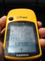
We are where we are supposed to be.
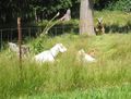
And there are goats nearby.


