Difference between revisions of "2010-07-19 52 0"
imported>Benjw m (new expedition - expanding expedition template) |
imported>Benjw (expedition report) |
||
| Line 1: | Line 1: | ||
| + | [[Image:{{{image|2010-07-19 52 0 obelisk.jpg}}}|thumb|left]] | ||
| − | |||
| − | |||
| − | |||
| − | |||
| − | |||
| − | |||
{{meetup graticule | {{meetup graticule | ||
| lat=52 | | lat=52 | ||
| lon=0 | | lon=0 | ||
| date=2010-07-19 | | date=2010-07-19 | ||
| + | | graticule_name=Cambridge | ||
| + | | graticule_link=Cambridge, United Kingdom | ||
}} | }} | ||
| − | |||
| − | |||
== Location == | == Location == | ||
| − | + | In the corner of a chalky field on top of a small hill west of Little Shelford, about 7km south of Cambridge. | |
== Participants == | == Participants == | ||
| − | + | Just [[User:Benjw|Benjw]]. | |
== Plans == | == Plans == | ||
| − | + | I've been to this field before while geocaching, so I think it's easily accessible. Will plan to go on the way home from work at about lunchtime. | |
== Expedition == | == Expedition == | ||
| − | + | Easy hash. Set off from home by bike at 05:45, reached hash 10km away by car at 12:10, went home. | |
| + | |||
| + | Perhaps a bit more detail would be nice. I don't normally take six hours to cycle 10km; rather, I had to put in an appearance at work in the meantime (that's where the car came from, too). This would have been a nice hash to walk to from home, but I have a statistics assignment due at 5pm tomorrow which I (ahem) haven't actually started yet, so I didn't really have the time. So I went on the way back from work instead. | ||
| + | |||
| + | This hash was (again) in a field, but I'd been here before while geocaching, so I thought it would be pretty accessible. I parked the car in a lay-by on the road at the bottom of the hill, then walked up a public footpath between fields and past a little area of woodland. Right at the top of the hill is an obelisk, which has an interesting story behind it. It was erected in 1739 by a local man in memory of his friend. The two men used to meet on this hill for country walks, geohashing not having been invented then, and they made a pact that when one of them died, the other would erect a monument in his memory. Accordingly, when in 1739 Mr Gregory Wale indeed died, his friend Mr James church had this stone erected. The inscription records that Mr Wale was | ||
| + | |||
| + | ::''Justice of the peace for this county, Deputy Lieutenant County Treasurer, Conservator of the River Cam... an advocate for liberty, a good subject, an agreeable companion, a faithful friend, an hospitable neighbour, and in all parts of life a useful member of society.'' | ||
| + | |||
| + | I'm a little surprised that he had time for any country walks. | ||
| + | |||
| + | Hidden in the woods near the obelisk is a geocache, which I'd already found, but went to find again. It turned out to be 260m from the hashpoint, which beats my previous [[hash collision]] honourable mention of 370m. | ||
| + | |||
| + | I then went to find the hashpoint itself, which was in a corner of the field. Handily, there was a ten-metre-wide stip of unplanted field all round the edge, so there was plenty of room to avoid trampling crops. The soil was baked hard by the hot weather we've had in the last month. It's very chalky soil around here so it appears very pale grey on the photos -- the colour and texture of concrete at the moment! | ||
| + | |||
| + | The actual hashpoint turned out to be a couple of metres inside the field, so I didn't have to go scrambling around in the undergrowth at the edge. Unfortunately, although I very carefully brought several sets of rechargeable batteries with me, only one set turned out to have any remaining power, so I wasn't able to use the GPS and the camera at the same time. | ||
| − | + | A few photos of the hashpoint and the view were taken, then I wandered back to the car, enjoying the hot sunshine and the insect life around -- mostly crickets and white butterflies. | |
| − | |||
| − | == | + | == Photographic documentation == |
| − | |||
| − | |||
| − | |||
<gallery perrow="5"> | <gallery perrow="5"> | ||
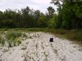
| + | Image:2010-07-19 52 0 bag at hashpoint.jpg | Bag marks the spot. I didn't have an X handy. | ||
| + | Image:2010-07-19 52 0 corner of field.jpg | ... and looking in the other direction. | ||
| + | Image:2010-07-19 52 0 ben at hashpoint.jpg | Squinting into the sun. | ||
| + | Image:2010-07-19 52 0 gps and coords.jpg | This would have been proof of hash but I didn't have enough batteries. | ||
| + | Image:2010-07-19 52 0 little shelford.jpg | Looking across to the nearby village. | ||
| + | Image:2010-07-19 52 0 obelisk.jpg | A 270-year-old obelisk in the same field. | ||
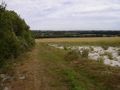
| + | Image:2010-07-19 52 0 across field.jpg | Looking from the obelisk towards the hashpoint. | ||
| + | Image:2010-07-19 52 0 inscription.jpg | The inscription on the obelisk. | ||
| + | Image:2010-07-19 52 0 geocache.jpg | Geocache found (again). | ||
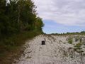
| + | Image:2010-07-19 52 0 path by field.jpg | Going back down the hill... | ||
| + | Image:2010-07-19 52 0 path through trees.jpg | ... through some nice trees. | ||
| + | Image:2010-07-19 52 0 cambridge.jpg | Looking north towards Cambridge. | ||
</gallery> | </gallery> | ||
== Achievements == | == Achievements == | ||
{{#vardefine:ribbonwidth|800px}} | {{#vardefine:ribbonwidth|800px}} | ||
| − | |||
| + | {{land geohash | ||
| + | | latitude = 52 | ||
| + | | longitude = 0 | ||
| + | | date = 2010-07-19 | ||
| + | | name = [[User:Benjw|Benjw]] | ||
| + | | image = 2010-07-19 52 0 ben at hashpoint.jpg | ||
| + | }} | ||
| + | {{Hash collision | ||
| + | | latitude = 52 | ||
| + | | longitude = 0 | ||
| + | | date = 2010-07-19 | ||
| + | | name = [[User:Benjw|Benjw]] | ||
| + | | id = GC100XH | ||
| + | | link = http://www.geocaching.com/seek/cache_details.aspx?guid=d09ca4d4-ea8c-4efd-b350-ec76d339e4cc | ||
| + | | distance = 370m | ||
| + | | honor = yes | ||
| + | }} | ||
| + | {{gratuitous ribbon | ||
| + | | icon = [[Compass.jpg]] | ||
| + | | latitude = 52 | ||
| + | | longitude = 0 | ||
| + | | date = 2010-07-19 | ||
| + | | achievement = Almost No Batteries Award | ||
| + | | description = bringing eleven batteries on a hashing expedition and finding only two of them worked. | ||
| + | | name = [[User:Benjw|Benjw]] | ||
| + | }} | ||
| − | |||
| − | |||
| − | |||
| − | |||
| − | |||
| − | |||
| − | |||
| − | |||
| − | |||
| − | |||
[[Category:Expeditions]] | [[Category:Expeditions]] | ||
| − | |||
[[Category:Expeditions with photos]] | [[Category:Expeditions with photos]] | ||
| − | |||
| − | |||
| − | |||
| − | |||
| − | |||
[[Category:Coordinates reached]] | [[Category:Coordinates reached]] | ||
| − | |||
| − | |||
| − | |||
| − | |||
| − | |||
| − | |||
| − | |||
| − | |||
| − | |||
| − | |||
Revision as of 19:58, 19 July 2010

| Mon 19 Jul 2010 in Cambridge: 52.1342798, 0.1051233 geohashing.info google osm bing/os kml crox |
Location
In the corner of a chalky field on top of a small hill west of Little Shelford, about 7km south of Cambridge.
Participants
Just Benjw.
Plans
I've been to this field before while geocaching, so I think it's easily accessible. Will plan to go on the way home from work at about lunchtime.
Expedition
Easy hash. Set off from home by bike at 05:45, reached hash 10km away by car at 12:10, went home.
Perhaps a bit more detail would be nice. I don't normally take six hours to cycle 10km; rather, I had to put in an appearance at work in the meantime (that's where the car came from, too). This would have been a nice hash to walk to from home, but I have a statistics assignment due at 5pm tomorrow which I (ahem) haven't actually started yet, so I didn't really have the time. So I went on the way back from work instead.
This hash was (again) in a field, but I'd been here before while geocaching, so I thought it would be pretty accessible. I parked the car in a lay-by on the road at the bottom of the hill, then walked up a public footpath between fields and past a little area of woodland. Right at the top of the hill is an obelisk, which has an interesting story behind it. It was erected in 1739 by a local man in memory of his friend. The two men used to meet on this hill for country walks, geohashing not having been invented then, and they made a pact that when one of them died, the other would erect a monument in his memory. Accordingly, when in 1739 Mr Gregory Wale indeed died, his friend Mr James church had this stone erected. The inscription records that Mr Wale was
- Justice of the peace for this county, Deputy Lieutenant County Treasurer, Conservator of the River Cam... an advocate for liberty, a good subject, an agreeable companion, a faithful friend, an hospitable neighbour, and in all parts of life a useful member of society.
I'm a little surprised that he had time for any country walks.
Hidden in the woods near the obelisk is a geocache, which I'd already found, but went to find again. It turned out to be 260m from the hashpoint, which beats my previous hash collision honourable mention of 370m.
I then went to find the hashpoint itself, which was in a corner of the field. Handily, there was a ten-metre-wide stip of unplanted field all round the edge, so there was plenty of room to avoid trampling crops. The soil was baked hard by the hot weather we've had in the last month. It's very chalky soil around here so it appears very pale grey on the photos -- the colour and texture of concrete at the moment!
The actual hashpoint turned out to be a couple of metres inside the field, so I didn't have to go scrambling around in the undergrowth at the edge. Unfortunately, although I very carefully brought several sets of rechargeable batteries with me, only one set turned out to have any remaining power, so I wasn't able to use the GPS and the camera at the same time.
A few photos of the hashpoint and the view were taken, then I wandered back to the car, enjoying the hot sunshine and the insect life around -- mostly crickets and white butterflies.
Photographic documentation
Bag marks the spot. I didn't have an X handy.
... and looking in the other direction.

Squinting into the sun.
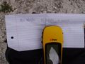
This would have been proof of hash but I didn't have enough batteries.
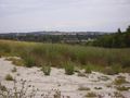
Looking across to the nearby village.
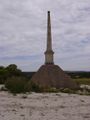
A 270-year-old obelisk in the same field.
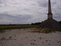
Looking from the obelisk towards the hashpoint.
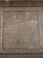
The inscription on the obelisk.
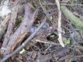
Geocache found (again).
Going back down the hill...
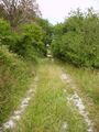
... through some nice trees.
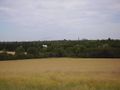
Looking north towards Cambridge.


Achievements
Benjw earned the Land geohash achievement
|
Benjw earned the Hash collision honorable mention
|
[[Image:Compass.jpg|44px]] |
Benjw earned the Almost No Batteries Award
|