2010-07-24 48 -123
| Sat 24 Jul 2010 in 48,-123: 48.6328885, -123.4948978 geohashing.info google osm bing/os kml crox |
Location
The middle of the Saanich Inlet, but relatively accessible by kayak from Brentwood Bay.
Participants
- Wenslayer (and maybe one of his kids too)
Plans
- Wenslayer: I plan to rent a kayak in Brentwood Bay, and paddle out to the location. I'll probably leave late morning.
Expedition
Although I had intended to take my eldest (9 years old) daughter kayaking with me for this Geohash, she couldn't come due to a prior engagement. I then asked my 6 year-old daughter if she wanted to come along, but she declined. Turns out it was a good thing I didn't drag along one of my kids.
I had intended to leave in the morning, but errands pushed back my start time to about 3pm. I drove to Brentwood Bay and made my way to Pacifica Paddle Sports where I rented a kayak for a couple hours. I explained my intentions to the proprietor, so he set me up with one of their faster kayaks and a quill-bladed paddle.
We made our way down to the dock and hoisted the kayak into the water next to the dock. He helped me in, and explained how I should sit, where I should rest my feet and brace my thighs on the inside of the kayak. It's then I noticed how "roll-y" the kayak was: by keeping my head still above the center of the kayak, I could easily roll the kayak down to either side. Although the kayak itself was quite stable, I had to be very careful about how I distributed my weight.

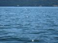
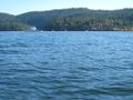
I pushed off and oriented myself to keep my momentum in a straight line. I managed to snap a picture of the Mill Bay Ferry as it headed out, although you can see that it's mostly of the water. That's because as I stopped paddling to fish out my camera, I had to lean a little to orient myself and that's when the kayak started rolling to either side as my weight shifted and I overcompensated. I realized I had to figure out how to best place my weight and not fight the natural rolling of the kayak. As a result, I just focused on paddling and kept the camera stashed.
As I rounded the first corner, where Senanus Island came into view, I could see that there were a bunch of war canoes out racing in this first bay (I can't find the name of it). I cut across this bay directly to the other side to avoid the race course. I would have taken some pictures, but I was still focusing on paddling.
I reached the point where Senanus Drive ends, and that's when two black head-sized mounds broke the surface off ahead to my left. I quickly realized they were scuba divers, so I paddled over to them to say hello. They told me they were searching for a sunken boat, but couldn't find it as visibility was limited to about 30 feet. How exciting! As I was slowly drifting onwards, I bade them good day and continued on. I realized a picture of them would have been interesting. Doh!
Up ahead, I could see that the water was choppier (6 inch waves, as opposed to 1 inch ripples) as I entered Coles Bay. The wind picked up as well, coming from the north-east. This made things a lot more "interesting", as in no fooling around now, as I had to focus on orienting the kayak properly to slice into the waves, and power forward to combat the wind. The waves were breaking over the front of the hull, so I was getting plenty splashed. I bore down and got into a rhythm of full strokes, all the while aiming for the point across Coles Bay.

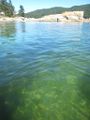
In what seemed like a much longer time that it probably took, I made it across Coles Bay to the point (at the end of Ardmore Drive) where the water was calm and the wind died down. There were some interesting rocks and I snapped a photo, showing how shallow they were. This is when I realized I had forgotten to bring along some water and a snack, as I was quite thirsty and a little peckish. I suddenly remembered a verse from Samuel Taylor Coleridge's The Rime of the Ancient Mariner:
- Water, water, everywhere,
- And all the boards did shrink;
- Water, water, everywhere,
- Nor any drop to drink.
Okay, I wasn't THAT thirsty, but you get my drift. :-)
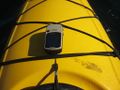
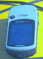
After a brief rest, I then took out my GPS to guide me to the Geohash point. The waters were smoother out here, and the wind was but a breeze. I started paddling out, but then I'd have to pause to check my GPS and ensure I was on track. After a few more attempts at this, I realized I wasn't going to be able to check often enough while still making progress. I then put the GPS under some bungy cords on the kayak hull in front of me so I could read the directional arrow and still paddle.
[more to come...]
Tracklog
[TBD]
Photos
Mill Bay Ferry leaving Brentwood Bay along with me.
A calm place to rest after crossing choppy Coles Bay.
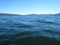
One of about 4 pictures snapped as I drifted through the Geohash coordinate.
Cropped and color-modified picture of above showing I made the coordinates.
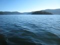
Looking south from the Geohash location.
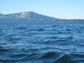
Looking north from the Geohash location (the barren hill is on Saltspring Island).
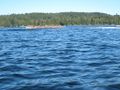
Senanus Island to my right as I paddled back.
The local tribe appeared to be holding war canoe races.
The Mill Bay Ferry heading out again.
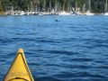
A seal bobbing just outside Brentwood Bay; all I managed to capture was the back of his head.
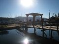
Relaxing afterwards at the Seahorses Cafe.
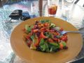
Reward for my efforts!


Achievements
Wenslayer earned the Water geohash achievement
|