Difference between revisions of "2010-07-27 45 -122"
imported>Jiml m (Add details) |
imported>FippeBot m (Location) |
||
| (3 intermediate revisions by one other user not shown) | |||
| Line 1: | Line 1: | ||
| − | + | [[Image:{{{image|2010-07-27_45_-122-area3.jpg | Area around the hashpoint}}}|thumb|left]] | |
| − | |||
| − | |||
| − | |||
| − | |||
| − | |||
| − | |||
| − | |||
{{meetup graticule | {{meetup graticule | ||
| lat=45 | | lat=45 | ||
| Line 16: | Line 9: | ||
__NOTOC__ | __NOTOC__ | ||
== Location == | == Location == | ||
| − | Near downtown Hillsboro! How can I turn it down? It might even be | + | Near downtown Hillsboro, Oregon! How can I turn it down? It might even be |
| − | an almost- | + | an almost-[[Cubicle geohash]]! |
== Participants == | == Participants == | ||
* [[User:Jiml|Jim]] | * [[User:Jiml|Jim]] | ||
| − | |||
== Plans == | == Plans == | ||
| Line 27: | Line 19: | ||
== Expedition == | == Expedition == | ||
| − | + | Well, it was after work. On my way to the Tuesday Evening Marketplace to get | |
| + | fruit and veggies and items for dinner, I turned onto 24th Ave and kept and eye on | ||
| + | my GPS. When I got close, I tried to find a place to park, then walked back a | ||
| + | couple of blocks. The hashpoint proved to be adjacent to what I think might have | ||
| + | been a private way. It had a number of houses on it, and almost seemed like a | ||
| + | street. | ||
| + | |||
| + | Towards the end of the street, my GPS pointed to the edge of the road, and I got close | ||
| + | enough to declare it a success without having to go up to door to ask permission to walk | ||
| + | onto the lawn. | ||
| + | |||
| + | I'm not certain yet, but I suspect this might be close enough to be an almost | ||
| + | honorable mention [[Cubicle geohash]], which might make the third of these I've | ||
| + | ended up with. (For some reason I'm reminded of the phrase "Always a Bridesmaid, never | ||
| + | a Bride".) | ||
| − | |||
| − | |||
| − | |||
== Photos == | == Photos == | ||
| − | + | ||
| − | |||
| − | |||
<gallery perrow="5"> | <gallery perrow="5"> | ||
| + | Image:2010-07-27_45_-122-area2.jpg | Driveway to the hashpoint | ||
| + | Image:2010-07-27_45_-122-area3.jpg | Area around the hashpoint | ||
| + | Image:2010-07-27_45_-122-hashpoint.jpg | The hashpoint itself | ||
| + | Image:2010-07-27_45_-122-area1.jpg | View up towards main road | ||
</gallery> | </gallery> | ||
== Achievements == | == Achievements == | ||
{{#vardefine:ribbonwidth|800px}} | {{#vardefine:ribbonwidth|800px}} | ||
| − | |||
| + | * Land Geohash | ||
| − | + | {{cubicle geohash | |
| − | + | | latitude=45 | |
| − | [[ | + | | longitude=-122 |
| + | | date=2010-07-27 | ||
| + | | name = [[User:Jiml|Jim]] | ||
| + | | honor = almost | ||
| − | + | }} | |
| + | [[Category:Expeditions]] | ||
| − | |||
| − | |||
| − | |||
[[Category:Expeditions with photos]] | [[Category:Expeditions with photos]] | ||
| − | + | ||
| − | |||
| − | |||
| − | |||
| − | |||
[[Category:Coordinates reached]] | [[Category:Coordinates reached]] | ||
| − | + | {{location|US|OR|WI}} | |
| − | |||
| − | |||
| − | |||
| − | |||
| − | |||
| − | |||
| − | |||
| − | |||
| − | |||
Latest revision as of 02:59, 9 August 2019

| Tue 27 Jul 2010 in 45,-122: 45.5140481, -122.9569078 geohashing.info google osm bing/os kml crox |
Location
Near downtown Hillsboro, Oregon! How can I turn it down? It might even be an almost-Cubicle geohash!
Participants
Plans
After work, I'd say. If only JoannaC were still here!
Expedition
Well, it was after work. On my way to the Tuesday Evening Marketplace to get fruit and veggies and items for dinner, I turned onto 24th Ave and kept and eye on my GPS. When I got close, I tried to find a place to park, then walked back a couple of blocks. The hashpoint proved to be adjacent to what I think might have been a private way. It had a number of houses on it, and almost seemed like a street.
Towards the end of the street, my GPS pointed to the edge of the road, and I got close enough to declare it a success without having to go up to door to ask permission to walk onto the lawn.
I'm not certain yet, but I suspect this might be close enough to be an almost honorable mention Cubicle geohash, which might make the third of these I've ended up with. (For some reason I'm reminded of the phrase "Always a Bridesmaid, never a Bride".)
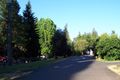
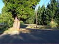
Photos
Driveway to the hashpoint
Area around the hashpoint
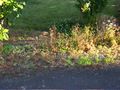
The hashpoint itself
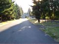
View up towards main road


Achievements
- Land Geohash
Jim earned the cubicle geohash almost honorable mention
|