Difference between revisions of "2010-07-31 46 -123"
imported>Aperfectring (+cats) |
imported>Aperfectring (+pics) |
||
| Line 55: | Line 55: | ||
--> | --> | ||
<gallery perrow="5"> | <gallery perrow="5"> | ||
| + | File:2010-07-31_46_-123_apr_01.jpg | View from the road | ||
| + | File:2010-07-31_46_-123_apr_02.jpg | Another view from the road | ||
| + | File:2010-07-31_46_-123_apr_03.jpg | The road at the point | ||
| + | File:2010-07-31_46_-123_apr_04.jpg | The road at the point going the other way | ||
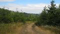
| + | File:2010-07-31_46_-123_apr_05.jpg | The way down | ||
| + | File:2010-07-31_46_-123_apr_06.jpg | A view from the hashpoint | ||
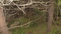
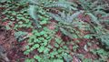
| + | File:2010-07-31_46_-123_apr_07.jpg | The clover covering the hashpoint | ||
| + | File:2010-07-31_46_-123_apr_08.jpg | Jim at the hashpoint | ||
| + | File:2010-07-31_46_-123_apr_09.jpg | Proof! | ||
| + | File:2010-07-31_46_-123_apr_10.jpg | Geotrash! | ||
| + | File:2010-07-31_46_-123_apr_11.jpg | Jim emerges from the brush all triumphant and stuff | ||
| + | File:2010-07-31_46_-123_apr_12.jpg | Former trainway! | ||
</gallery> | </gallery> | ||
Revision as of 05:22, 1 August 2010
| Sat 31 Jul 2010 in 46,-123: 46.0601459, -123.2629227 geohashing.info google osm bing/os kml crox |
Location
Close to Hwy 47 Near Mist Oregon
Participants
Plans
APR first mentioned this hashpoint, though Jim had noticed it was a possible since it is near the "bottom" of the graticule.
APR's worried about Beach Traffic, but Jim doesn't think it will be that much of a problem. Jim need to go to the Farmer's Market earlier in the day, though.
APR wants to get out for a morning bike ride, so later in the day should be fine. Meet up at 2PM?
Today's battleship location is: H 1
Expedition
- Trying to hitch a ride from a good sumeritan. -- apr @45.5219,-122.9723 22:25, 31 July 2010 (UTC)
- About to go bushwhacking, wish us luck! -- aperfectring @46.0604,-123.2634 23:54, 31 July 2010 (UTC)
- Success! A great example of the bushwhacking we portlanders do! -- aperfectring @46.0605,-123.2635 00:14, 1 August 2010 (UTC)
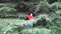
Jim was a good Samaritan, and picked up APR around 3:30PM local time. They then proceeded to drive through the light traffic all the way up near Mist, Oregon. When they got to the point on the road closest to the hashpoint, they found a place to pull off, and donned some boots, to make the bushwhacking easier. They then walked down the short straight stretch, and looked for the best place to make their way into the hashpoint. The road was built up on a grade, so it was a rather steep way down to the normal level of the ground, but after that, the ground seemed to have only a slight downhill. Eventually they decided that the easiest way down was near the car. They then proceeded down through the woods, with only a few thorny spots, desperately trying to get and keep signal on the GPS units. After a few minutes of stumbling around in the dark undergrowth of the woods, they found a small patch of clover which seemed to be close enough, if not on, the spot of the geohash. Even if it wasn't the exact spot, they had tromped around more than enough to have walked right through it.
After the obligatory picture taking, they slowly worked their way back out, more or less the same way that they entered. On the trip back, Jim kindly slowed down for APR to take a picture of a nice wooden trestle railway bridge, which most assuredly no longer carries trains. It was at this point that Jim noticed his car was running a bit low on gas. Since they were relatively near home at this point, they waited until they got to North Plains to get some gas. They then proceeded onwards to the Washington County Fair, where they looked at livestock and crafts, and they got corn dogs, corn on the cob, and milk shakes.
Tracklog
Photos
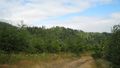
View from the road
Another view from the road
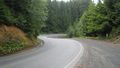
The road at the point

The road at the point going the other way
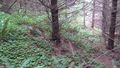
The way down
A view from the hashpoint
The clover covering the hashpoint

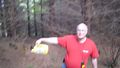
Jim at the hashpoint
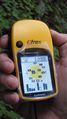
Proof!
Geotrash!
Jim emerges from the brush all triumphant and stuff
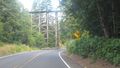
Former trainway!


