Difference between revisions of "2010-08-02 48 -122"
imported>Wenslayer (Created page with '{{subst:Expedition |lat = 48 |lon = -122 |date = 2010-08-02 }}') |
imported>Wenslayer (Write up with photos) |
||
| Line 1: | Line 1: | ||
| − | |||
| − | |||
| − | |||
| − | |||
| − | |||
| − | |||
| − | |||
| − | |||
| − | |||
| − | |||
{{meetup graticule | {{meetup graticule | ||
| lat=48 | | lat=48 | ||
| Line 15: | Line 5: | ||
}} | }} | ||
| − | |||
__NOTOC__ | __NOTOC__ | ||
== Location == | == Location == | ||
| − | + | Near Birch Bay in an overgrown field. | |
== Participants == | == Participants == | ||
| − | + | * [[User:Wenslayer|Wenslayer]] | |
== Plans == | == Plans == | ||
| − | + | * [[User:Wenslayer|Wenslayer]]: Since it was my birthday, and essentially a stone's throw away from the freeway upon which I would be driving, I figured I ought to at least try, despite the satellite maps showing it in the middle of undeveloped property. | |
== Expedition == | == Expedition == | ||
| − | + | We spent the weekend down in Seattle with friends, doing a little training for our upcoming Whistler Gran Fondo. As Monday was a holiday in BC (as well as my birthday, albeit a coincidence), we figured we'd drive back home this day, and take a small detour to attempt the Geohash. | |
| − | + | I memorized the easy directions from the freeway, and made our way to a spot on the road closest to the Geohash. All along that road, the undeveloped property was a mess of overgrown brush, with blackberry bushes comprising the bulk of vegetation near the road. Not seeing any easy break in the vegetation to get close to the point, I found a small driveway that took me the closest way there, but in the end, I was stymied by Mother Nature. | |
| − | + | ||
| + | Took a couple pics, jumped back in the car and continued on home. | ||
== Photos == | == Photos == | ||
| − | < | + | <gallery perrow="3"> |
| − | Image:2010- | + | Image:2010-08-03_48_-122_brambles.jpg | Mother Nature guarding her domain. |
| − | -- | + | Image:2010-08-03_48_-122_gps.jpg | As close as I was going to get that day. |
| − | + | Image:2010-08-03_48_-122_sosad.jpg | [[User:Wenslayer|Wenslayer]] is sad when he can't reach the Geohash coordinates. | |
</gallery> | </gallery> | ||
== Achievements == | == Achievements == | ||
{{#vardefine:ribbonwidth|800px}} | {{#vardefine:ribbonwidth|800px}} | ||
| − | + | So close to a [[Birthday Geohash]]; 316m close to be exact. | |
| − | |||
| − | |||
| − | |||
| − | |||
| − | |||
| − | |||
| − | |||
| − | |||
| − | |||
| − | |||
| − | |||
[[Category:Expeditions]] | [[Category:Expeditions]] | ||
| − | |||
[[Category:Expeditions with photos]] | [[Category:Expeditions with photos]] | ||
| − | |||
| − | |||
| − | |||
| − | |||
| − | |||
| − | |||
| − | |||
| − | |||
| − | |||
[[Category:Coordinates not reached]] | [[Category:Coordinates not reached]] | ||
| − | |||
[[Category:Not reached - Mother Nature]] | [[Category:Not reached - Mother Nature]] | ||
| − | |||
| − | |||
| − | |||
| − | |||
Revision as of 05:28, 3 August 2010
| Mon 2 Aug 2010 in 48,-122: 48.9089887, -122.7134771 geohashing.info google osm bing/os kml crox |
Location
Near Birch Bay in an overgrown field.
Participants
Plans
- Wenslayer: Since it was my birthday, and essentially a stone's throw away from the freeway upon which I would be driving, I figured I ought to at least try, despite the satellite maps showing it in the middle of undeveloped property.
Expedition
We spent the weekend down in Seattle with friends, doing a little training for our upcoming Whistler Gran Fondo. As Monday was a holiday in BC (as well as my birthday, albeit a coincidence), we figured we'd drive back home this day, and take a small detour to attempt the Geohash.
I memorized the easy directions from the freeway, and made our way to a spot on the road closest to the Geohash. All along that road, the undeveloped property was a mess of overgrown brush, with blackberry bushes comprising the bulk of vegetation near the road. Not seeing any easy break in the vegetation to get close to the point, I found a small driveway that took me the closest way there, but in the end, I was stymied by Mother Nature.
Took a couple pics, jumped back in the car and continued on home.
Photos
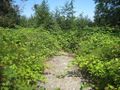
Mother Nature guarding her domain.
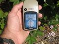
As close as I was going to get that day.
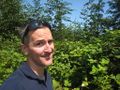
Wenslayer is sad when he can't reach the Geohash coordinates.


Achievements
So close to a Birthday Geohash; 316m close to be exact.