Difference between revisions of "2010-08-04 55 13"
imported>Fasanen (→Photos) |
imported>FippeBot m (Location) |
||
| (12 intermediate revisions by 3 users not shown) | |||
| Line 18: | Line 18: | ||
__NOTOC__ | __NOTOC__ | ||
== Location == | == Location == | ||
| − | In the forest not far from a road | + | In the forest, not far from a road; about a kilometer west of Häckeberga Lake. |
== Participants == | == Participants == | ||
| − | * [[User:Fasanen|Fasanen]] | + | * [[User:Fasanen|Fasanen]], Mr.T & Ms.C |
| − | |||
| − | |||
* Lillangen | * Lillangen | ||
| − | * | + | * [[User:Llavids|Llavids]] |
== Plans == | == Plans == | ||
| − | By looking at aerial photographs, this hashpoint does not seem | + | By looking at aerial photographs, this hashpoint does not seem too difficult to reach. It's not far from the road and if we're lucky it's also in quite passable beech forest. We'll try to be there at noon and will bring some lunch with us. /Fasanen |
I might be there too/ Lillangen | I might be there too/ Lillangen | ||
| Line 37: | Line 35: | ||
== Expedition == | == Expedition == | ||
| − | We arrived at the road gate just before noon. | + | We arrived at the road gate just before noon. Llavids and Lillangen were already there. It turned out that we were ten people and one dog that had gathered for this expedition. What a crowd! Amazing! |
| − | We began walking the half kilometer to the hash point and I realized that I had walked part of the road three years earlier in a quest for a mystery geochache. We passed the cache location and an eternity tree before we got to the hash which was located in quite easy terrain. After planting stick with a geohashing | + | We began walking the half kilometer to the hash point and I realized that I had walked part of the road three years earlier in a quest for a mystery geochache. We passed the cache location and an eternity tree before we got to the hash which was located in quite easy terrain. After planting a stick with a geohashing flier and taking photographic proofs and group photos we walked back and had a picnic outside an old earth cellar. A young couple passed by. They seemed a bit overdressed for the environment, carried groceries and were interested in insects. They eventually wandered off into the woods. After spending an hour telling old geocaching war stories and finding the mystery cache, we headed back to our cars. |
| − | Lillangen who was a bit in a hurry, had left slightly earlier but | + | Lillangen who was a bit in a hurry, had left slightly earlier but came back running towards us and told that our cars were blocking a big lumber truck that wanted to drive on the closed road. We rushed to the cars which we hastily packed and departed, leaving the poor young couple's car. |
| + | |||
| + | I don't know the end of that story but we had a great afternoon. '''- Fasanen''' | ||
== Photos == | == Photos == | ||
| − | + | ||
| − | |||
| − | |||
<gallery perrow="5"> | <gallery perrow="5"> | ||
Image:5513201008004 1.JPG | The road to the hash | Image:5513201008004 1.JPG | The road to the hash | ||
| Line 56: | Line 54: | ||
Image:5513201008004 7.JPG | General setting II | Image:5513201008004 7.JPG | General setting II | ||
Image:5513201008004 8.JPG | Mysterious earth cellar | Image:5513201008004 8.JPG | Mysterious earth cellar | ||
| − | Image:551320100804 9.jpg | Hash | + | Image:551320100804 9.jpg | Hash habitat |
Image:551320100804 10.jpg | Some expedition members | Image:551320100804 10.jpg | Some expedition members | ||
</gallery> | </gallery> | ||
| Line 62: | Line 60: | ||
== Achievements == | == Achievements == | ||
{{#vardefine:ribbonwidth|800px}} | {{#vardefine:ribbonwidth|800px}} | ||
| − | + | {{Largest geohash | latitude = 55 | longitude = 13 | date = 2010-08-04 | number = 10 | graticule = Malmö, Sweden}} | |
| − | + | {{land geohash | latitude=55 | longitude=13 | date=2010-08-04 | name=Llavids }} | |
| − | + | {{drag-along | latitude = 55 | longitude = 13 | date = 2010-08-04 | partner = whole family | name = Llavids}} | |
| − | + | {{Meet-up | latitude = 55 | longitude = 13 | date = 2010-08-04 | name = [[User:Llavids|Llavids]] | other = [[User:Fasanen|Fasanen]] }} | |
| − | + | {{Picnic | latitude = 55 | longitude = 13 | date = 2010-08-04 | name = Llavids }} | |
| − | + | {{land geohash | latitude=55 | longitude=13 | date=2010-08-04 | name=Fasanen }} | |
| − | + | {{drag-along | latitude = 55 | longitude = 13 | date = 2010-08-04 | partner = his daughter (Ms.C) | name = Fasanen}} | |
| − | [[ | + | {{Meet-up | latitude = 55 | longitude = 13 | date = 2010-08-04 | name = [[User:Fasanen|Fasanen]] | other = [[User:Llavids|Llavids]] }} |
| + | {{Picnic | latitude = 55 | longitude = 13 | date = 2010-08-04 | name = Fasanen }} | ||
| − | |||
| − | |||
[[Category:Expeditions]] | [[Category:Expeditions]] | ||
| − | |||
[[Category:Expeditions with photos]] | [[Category:Expeditions with photos]] | ||
| − | |||
| − | |||
| − | |||
| − | |||
| − | |||
| − | |||
[[Category:Coordinates reached]] | [[Category:Coordinates reached]] | ||
| − | + | [[Category:Sweden]] | |
| − | + | {{location|SE|M}} | |
| − | |||
| − | |||
| − | |||
| − | |||
| − | |||
| − | |||
| − | |||
| − | [[Category: | ||
| − | |||
Latest revision as of 03:07, 9 August 2019
| Wed 4 Aug 2010 in 55,13: 55.5752561, 13.3889032 geohashing.info google osm bing/os kml crox |
Location
In the forest, not far from a road; about a kilometer west of Häckeberga Lake.
Participants
Plans
By looking at aerial photographs, this hashpoint does not seem too difficult to reach. It's not far from the road and if we're lucky it's also in quite passable beech forest. We'll try to be there at noon and will bring some lunch with us. /Fasanen
I might be there too/ Lillangen
And we // llavids
The road next to the hashpoint seems to be closed so there will probably be half a kilometer of walking/bicycling to the coordinates./Fasanen
Expedition
We arrived at the road gate just before noon. Llavids and Lillangen were already there. It turned out that we were ten people and one dog that had gathered for this expedition. What a crowd! Amazing!
We began walking the half kilometer to the hash point and I realized that I had walked part of the road three years earlier in a quest for a mystery geochache. We passed the cache location and an eternity tree before we got to the hash which was located in quite easy terrain. After planting a stick with a geohashing flier and taking photographic proofs and group photos we walked back and had a picnic outside an old earth cellar. A young couple passed by. They seemed a bit overdressed for the environment, carried groceries and were interested in insects. They eventually wandered off into the woods. After spending an hour telling old geocaching war stories and finding the mystery cache, we headed back to our cars.
Lillangen who was a bit in a hurry, had left slightly earlier but came back running towards us and told that our cars were blocking a big lumber truck that wanted to drive on the closed road. We rushed to the cars which we hastily packed and departed, leaving the poor young couple's car.
I don't know the end of that story but we had a great afternoon. - Fasanen
Photos
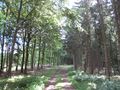
The road to the hash
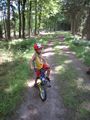
Mr.T going by bike
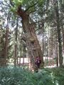
Eternity tree
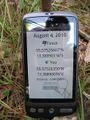
Proof
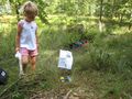
Ms.C at hash
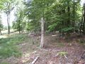
General setting I
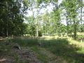
General setting II
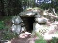
Mysterious earth cellar
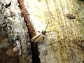
Hash habitat
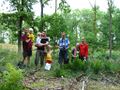
Some expedition members


Achievements
Malmö, Sweden earned the Largest geohash achievement
|
Llavids earned the Land geohash achievement
|
Llavids earned the Drag-along achievement
|
Llavids earned the Meet-up achievement
|
Llavids earned the Picnic achievement
|
Fasanen earned the Land geohash achievement
|
Fasanen earned the Drag-along achievement
|
Fasanen earned the Meet-up achievement
|
Fasanen earned the Picnic achievement
|