Difference between revisions of "2010-08-07 -36 174"
From Geohashing
imported>Greenslime (→Photos) |
imported>Greenslime m (→Photos) |
||
| Line 37: | Line 37: | ||
Image:2010-##-## ## ## Alpha.jpg | Witty Comment | Image:2010-##-## ## ## Alpha.jpg | Witty Comment | ||
--> | --> | ||
| − | <gallery perrow=" | + | <gallery perrow="3"> |
Image:2010-08-07 -36 174 gmap.JPG|Satellite image of the hash | Image:2010-08-07 -36 174 gmap.JPG|Satellite image of the hash | ||
</gallery> | </gallery> | ||
Revision as of 21:54, 6 August 2010
| Sat 7 Aug 2010 in -36,174: -36.8714800, 174.7146075 geohashing.info google osm bing/os kml crox |
Location
On the edge of Chamberland Park Golf Course, Point Chevalier, Auckland
Participants
- Greenslime
- JimmyNZ thought about it, but unfortunately, as he is currently geographically incapacitated, wouldn't be joining
Plans
Now I honestly truly contemplated doing the whole public transport thing, but its just way too hard in Auckland. So im going to hop in my car and drive to the hash! Its raining, so its unlikely there will be many people playing golf.
Expedition
Tracklog
Photos
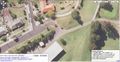
Satellite image of the hash

Achievements