Difference between revisions of "2010-08-08 -36 174"
imported>Greenslime (Created page with '{{subst:Expedition |lat = -36 |lon = 174 |date = 2010-08-08 }}') |
imported>FippeBot m (Location) |
||
| (13 intermediate revisions by one other user not shown) | |||
| Line 1: | Line 1: | ||
| − | |||
| − | |||
| − | |||
| − | |||
| − | |||
| − | |||
| − | |||
| − | |||
| − | |||
| − | |||
{{meetup graticule | {{meetup graticule | ||
| lat=-36 | | lat=-36 | ||
| Line 15: | Line 5: | ||
}} | }} | ||
| − | |||
__NOTOC__ | __NOTOC__ | ||
== Location == | == Location == | ||
| − | + | Off the western coastline of Musick Point/Te Waiarohia or Howick golf course | |
== Participants == | == Participants == | ||
| − | + | * [[User:Greenslime|Greenslime]] | |
| + | * Maximus Adonis | ||
== Plans == | == Plans == | ||
| − | + | Satellite imagery suggests that this hash could be accessible at low tide, hence i will ensure that i am on location at 11:00 on sunday to take a look. Research [[http://www.manukau.govt.nz/EN/Yourcommunity/ParksWalksBeaches/FindAPark/Pages/MusickPointTeWaiarohia.aspx]] shows that the peninsula 'encompasses a narrow band of steep coastal cliffs dominated by mature pohutukawa' hence there may be a quantity of walking up the length of the peninsula involved, probably in mud. | |
== Expedition == | == Expedition == | ||
| − | + | First of all, drag-along participant Max was uplifted from his home way the hell out in the middle of no where. He had agreed to be transported to a random gps coordinate with the promise of a free lunch. This hash had to be timed right because of tides and we arrived at Musick Point bang on low tide. It was another spectacularly rainy Auckland day, and Green left her rain coat in the car. Max had an umbrella, but seemed unwilling to share it. Too bad, I had a kite and I was unwilling to share that either. | |
| + | |||
| + | Despite the mud there were no dramatic loss of traction moments, the wave cut platform was pretty easy to walk on and we tried to avoid trampling the mussel colonies. The hash coordinates were reached with no dramas, and no wet feet (gumboots man, good planning) The GPS function on my Nokia was used to find the hash location. Im still unfamiliar with how to use it, but i think i got to the right place. | ||
| + | |||
| + | Third most exciting thing of the hash was the discarded shopping trolley, second was the free golf ball that was found, and the most exciting thing was the windiness which was perfect for kite flying! Yay, mission accomplished. | ||
== Tracklog == | == Tracklog == | ||
| − | + | SH1 to south eastern highway, Pakuranga Highway, Bucklands Beach road to Musick Point. Amble down the stairs to the wave cut platform. | |
== Photos == | == Photos == | ||
| − | + | ||
| − | |||
| − | |||
<gallery perrow="5"> | <gallery perrow="5"> | ||
| + | Image:2010-08-08_-36_174_gmap.JPG|Satellite image of the hash location | ||
| + | Image:2010-08-08 -36 174 Musick Point.jpg|Musick Point | ||
| + | Image:2010-08-08_-36_174_Green_at_the_hash.jpg|Green at the hash location | ||
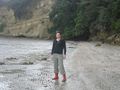
| + | Image:2010-08-08 -36 174 view from hash.jpg|View of Rangitoto Island from the hash | ||
| + | Image:2010-08-08_-36_174_Fly_a_kite.jpg|If at all possible, fly a kite! | ||
| + | Image:2010-08-08 -36 174 geotrash.jpg|Some geotrash is just too large to extract | ||
| + | Image:2010-08-08 -36 174 GPS reflections.jpg|Maximus dealing with GPS versus nature | ||
| + | Image:2010-08-08 -36 174 GPS.jpg|Proof | ||
</gallery> | </gallery> | ||
== Achievements == | == Achievements == | ||
{{#vardefine:ribbonwidth|800px}} | {{#vardefine:ribbonwidth|800px}} | ||
| − | |||
| − | + | {{Ribbon | |
| − | + | |icon = XKCD_235_kite_2.jpg | |
| − | + | |color = blue | |
| − | + | |user = [[user:Greenslime|Greenslime]] | |
| − | + | |achievement = [[Fly a kite achievement]] | |
| − | + | |action = flying a kite at the [[2010-08-08 -36 174|2010-08-08 -36 174]] hash | |
| − | + | |category = Fly a kite achievement | |
| − | [[ | + | |image = 2010-08-08_-36_174_Fly_a_kite.jpg |
| − | -- | + | }} |
| − | + | {{drag-along | |
| − | + | | latitude = -36 | |
| + | | longitude = 174 | ||
| + | | date = 2010-08-08 | ||
| + | | partner = Maximus Adonis | ||
| + | | name = [[User:Greenslime|Greenslime]] | ||
| + | | image = 2010-08-08_-36_174_geotrash.jpg | ||
| + | }} | ||
| + | {{consecutive geohash | ||
| + | | count = 2 | ||
| + | | latitude = -36 | ||
| + | | longitude = 174 | ||
| + | | date = 2010-08-07 | ||
| + | | name = [[User:Greenslime|Greenslime]] | ||
| + | }} | ||
[[Category:Expeditions]] | [[Category:Expeditions]] | ||
| − | |||
[[Category:Expeditions with photos]] | [[Category:Expeditions with photos]] | ||
| − | |||
| − | |||
| − | |||
| − | |||
| − | |||
[[Category:Coordinates reached]] | [[Category:Coordinates reached]] | ||
| − | + | {{location|NZ|AUK}} | |
| − | |||
| − | |||
| − | |||
| − | |||
| − | |||
| − | |||
| − | |||
| − | |||
| − | |||
Latest revision as of 03:10, 9 August 2019
| Sun 8 Aug 2010 in -36,174: -36.8514438, 174.8988717 geohashing.info google osm bing/os kml crox |
Location
Off the western coastline of Musick Point/Te Waiarohia or Howick golf course
Participants
- Greenslime
- Maximus Adonis
Plans
Satellite imagery suggests that this hash could be accessible at low tide, hence i will ensure that i am on location at 11:00 on sunday to take a look. Research [[1]] shows that the peninsula 'encompasses a narrow band of steep coastal cliffs dominated by mature pohutukawa' hence there may be a quantity of walking up the length of the peninsula involved, probably in mud.
Expedition
First of all, drag-along participant Max was uplifted from his home way the hell out in the middle of no where. He had agreed to be transported to a random gps coordinate with the promise of a free lunch. This hash had to be timed right because of tides and we arrived at Musick Point bang on low tide. It was another spectacularly rainy Auckland day, and Green left her rain coat in the car. Max had an umbrella, but seemed unwilling to share it. Too bad, I had a kite and I was unwilling to share that either.
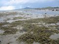
Despite the mud there were no dramatic loss of traction moments, the wave cut platform was pretty easy to walk on and we tried to avoid trampling the mussel colonies. The hash coordinates were reached with no dramas, and no wet feet (gumboots man, good planning) The GPS function on my Nokia was used to find the hash location. Im still unfamiliar with how to use it, but i think i got to the right place.
Third most exciting thing of the hash was the discarded shopping trolley, second was the free golf ball that was found, and the most exciting thing was the windiness which was perfect for kite flying! Yay, mission accomplished.
Tracklog
SH1 to south eastern highway, Pakuranga Highway, Bucklands Beach road to Musick Point. Amble down the stairs to the wave cut platform.
Photos
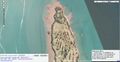
Satellite image of the hash location
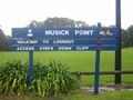
Musick Point
Green at the hash location
View of Rangitoto Island from the hash
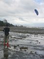
If at all possible, fly a kite!
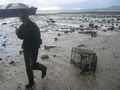
Some geotrash is just too large to extract
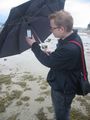
Maximus dealing with GPS versus nature
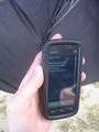
Proof


Achievements
Greenslime earned the Fly a kite achievement
|
Greenslime earned the Drag-along achievement
|
Greenslime earned the Consecutive geohash achievement
|