Difference between revisions of "2010-08-10 -36 174"
imported>Greenslime m |
imported>Greenslime m |
||
| Line 26: | Line 26: | ||
== Expedition == | == Expedition == | ||
| − | + | Well, exciting lab results kept me at uni way longer than I expected. As time was passing by I was thinking secretly that maybe I could get there in time for a sunset hash, combined with a lovely, romantic, sunset walk along the beach with myself, on a clear, winter, Auckland, non raining evening. Sadly wasn't to be the case, Auckland's traffic intervened and Green got her first introduction to dark time hashing. Well aside from it being rather boring, its notoriously difficult to photograph, well anything. Street Signs, GPS screens, and there's the fact that you look very dodgy milling around the front of someone's property. I was busted instantly on pulling up outside the house by someone looking out the window, so I had to drive down the road, do a 'u'ey and stroll back up on foot. I was dead scared id be confronted that I only just made it to outside number 69 De Luen Avenue, and stayed only long enough to take a quick snap shot of the GPS. On that note, whats this 37 m accuracy crap, that makes me want to throw the thing away - maybe it needs calibration? | |
| + | |||
| + | So, the most exciting thing about this hash, that it actually landed on land, take a look at the map! | ||
== Tracklog == | == Tracklog == | ||
| − | + | SH1 north, off at Orewa, onto Whangaparoa Road, down Tidsall Beach road, onto De Luen. | |
== Photos == | == Photos == | ||
<gallery perrow="5"> | <gallery perrow="5"> | ||
Image:20100810 -36 174 Gmap.JPG| Satellite imagery of hash location | Image:20100810 -36 174 Gmap.JPG| Satellite imagery of hash location | ||
| + | Image:20100810 -36 174 De Luen.jpg| De Luen Avenue | ||
| + | Image:20100810 -36 174 GPS.jpg|GPS proof | ||
</gallery> | </gallery> | ||
| Line 39: | Line 43: | ||
{{#vardefine:ribbonwidth|800px}} | {{#vardefine:ribbonwidth|800px}} | ||
<!-- Add any achievement ribbons you earned below, or remove this section --> | <!-- Add any achievement ribbons you earned below, or remove this section --> | ||
| + | Nothing special here | ||
| − | |||
| − | |||
| − | |||
| − | |||
| − | |||
| − | |||
| − | |||
| − | |||
| − | |||
| − | |||
| − | |||
| − | |||
[[Category:Expeditions]] | [[Category:Expeditions]] | ||
| − | + | [[Category:Expeditions with photos]] | |
| − | [[Category:Expeditions with photos]] | ||
| − | |||
| − | |||
| − | |||
| − | |||
| − | |||
[[Category:Coordinates reached]] | [[Category:Coordinates reached]] | ||
| − | |||
| − | |||
| − | |||
| − | |||
| − | |||
| − | |||
| − | |||
| − | |||
| − | |||
| − | |||
Revision as of 10:02, 10 August 2010
| Tue 10 Aug 2010 in -36,174: -36.6189153, 174.7722010 geohashing.info google osm bing/os kml crox |
Location
A house, Tindalls Beach, Whangaparoa Peninsula, Auckland
Participants
Plans
What a bounty of Hashes Auckland has had of recent! I will drive up there after work as its not too far past my house on SH1. The hash is in someones house, so will get to the road edge atleast.
Expedition
Well, exciting lab results kept me at uni way longer than I expected. As time was passing by I was thinking secretly that maybe I could get there in time for a sunset hash, combined with a lovely, romantic, sunset walk along the beach with myself, on a clear, winter, Auckland, non raining evening. Sadly wasn't to be the case, Auckland's traffic intervened and Green got her first introduction to dark time hashing. Well aside from it being rather boring, its notoriously difficult to photograph, well anything. Street Signs, GPS screens, and there's the fact that you look very dodgy milling around the front of someone's property. I was busted instantly on pulling up outside the house by someone looking out the window, so I had to drive down the road, do a 'u'ey and stroll back up on foot. I was dead scared id be confronted that I only just made it to outside number 69 De Luen Avenue, and stayed only long enough to take a quick snap shot of the GPS. On that note, whats this 37 m accuracy crap, that makes me want to throw the thing away - maybe it needs calibration?
So, the most exciting thing about this hash, that it actually landed on land, take a look at the map!
Tracklog
SH1 north, off at Orewa, onto Whangaparoa Road, down Tidsall Beach road, onto De Luen.
Photos
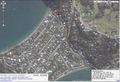
Satellite imagery of hash location
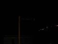
De Luen Avenue
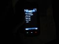
GPS proof


Achievements
Nothing special here