Difference between revisions of "2010-08-11 52 1"
From Geohashing
imported>Sourcerer |
imported>Sourcerer m |
||
| Line 31: | Line 31: | ||
Image:2010-08-11_52_1_Sun_Flowers.JPG|Sun Flower Field. | Image:2010-08-11_52_1_Sun_Flowers.JPG|Sun Flower Field. | ||
</gallery> | </gallery> | ||
| + | |||
| + | [[Category: Meetup on 2010-08-11]] | ||
| + | [[Category: Meetup in 52 1]] | ||
Revision as of 19:44, 28 August 2010
Location
In a wheat field north of Laxfield, Suffolk, United Kingdom. The hash point was on a public footpath path and easy to get to. There is a GPS path here at wikiloc.
The return route was less easy. Although using public footpaths, there were three deep unbridged drainage ditches to negotiate. These needed some agility and a willingness to ignore water, mud, nettles and thistles. It was obvious from the vegetation that others had performed a glassade (a glisade performed by sliding on ones rear end) in order to cross the ditches.
| Wed 11 Aug 2010 in Norwich: 52.3196175, 1.3508862 geohashing.info google osm bing/os kml crox |
Participants
Expedition
Sourcerer (Neil) went on a 5 mile walk starting and ending in Laxfield with a convenient pub at the end of the walk.
Image Gallery
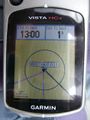
Satnav Evidence.
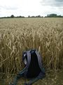
Wheat Field 1.
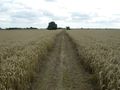
Wheat Field 2.
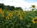
Sun Flower Field.


