Difference between revisions of "2010-08-13 42 -121"
imported>Michael5000 (→Participants) |
m (per Renaming Proposal) |
||
| (9 intermediate revisions by 3 users not shown) | |||
| Line 1: | Line 1: | ||
| − | |||
| − | |||
| − | |||
| − | |||
| − | |||
| − | |||
| − | |||
| − | |||
| − | |||
| − | |||
{{meetup graticule | {{meetup graticule | ||
| lat=42 | | lat=42 | ||
| Line 14: | Line 4: | ||
| date=2010-08-13 | | date=2010-08-13 | ||
}} | }} | ||
| − | |||
| − | |||
__NOTOC__ | __NOTOC__ | ||
== Location == | == Location == | ||
| Line 22: | Line 10: | ||
== Participants == | == Participants == | ||
| + | |||
*[[User:Michael5000|Michael5000]] | *[[User:Michael5000|Michael5000]] | ||
*[[User:Mrs.5000|Mrs.5000]] | *[[User:Mrs.5000|Mrs.5000]] | ||
| − | == | + | == Expedition == |
| − | |||
| − | + | From base camp at BigBrother5000's house in Ashland, we drove Oregon 140 and secondary roads over the mountains and north of Klamath Lake to Chiloquin, Oregon. Chiloquin Ridge Road, a well-maintained two-lane road, brought us to within about a third of a mile of the site. We had an easy hike up through sparse forest and sandy soil, and located the hashpoint without difficulty. Unfortunately, the nearest remarkable landmark was a large pile of household trash that someone must have discarded in the woods sometime in the past few years. | |
| − | + | ||
| + | It being Michael5000's birthday, he opened his present from Mrs.5000 -- which turned out to be a fabulous piece of original art -- at the hashpoint. | ||
| − | + | This is assumed to be the first Expedition and the first successful Expedition of the Klamath Falls, Oregon, graticule. | |
| − | |||
== Photos == | == Photos == | ||
| − | + | ||
| − | |||
| − | |||
<gallery perrow="5"> | <gallery perrow="5"> | ||
| + | File:2010-08-13_42_-121_Sun-Bleached_Bones.jpg|Michael nervously examines the sun-bleached bones of geohashers that came before. | ||
| + | File:2010-08-13 42 -121 midden.jpg|An unfortunate trash heap near the hashpoint. | ||
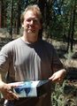
| + | File:2010-08-13 42 -121 Mrs5000.jpg|Mrs.5000 at the hashpoint. | ||
| + | File:2010-08-13_42_-121_Present.jpg|Michael5000 opens his birthday present. | ||
| + | File:2010-08-13 42 -121 Art in the Woods.jpg|Michael's present, an object d'art, hangs briefly in the woods. | ||
| + | File:2010-08-13 42 -121 Archery and Piano Tuning.jpg|Small town business enterprise in Southern Oregon | ||
</gallery> | </gallery> | ||
== Achievements == | == Achievements == | ||
{{#vardefine:ribbonwidth|800px}} | {{#vardefine:ribbonwidth|800px}} | ||
| − | |||
| + | {{Graticule unlocked | ||
| + | | latitude = 42 | ||
| + | | longitude = -121 | ||
| + | | date = 2010-08-13 | ||
| + | | name = [[User:Michael5000|Michael5000]] and [[User:Mrs.5000|Mrs.5000]] | ||
| + | }} | ||
| − | + | {{Birthday geohash | |
| − | + | | latitude = 42 | |
| − | [[ | + | | longitude = -121 |
| + | | date = 2010-08-13 | ||
| + | | pronoun = his | ||
| + | | number = 42nd | ||
| + | | name = [[User:Michael5000|Michael5000]] | ||
| + | }} | ||
| − | |||
| − | |||
| − | |||
| − | |||
| − | |||
| − | |||
[[Category:Expeditions]] | [[Category:Expeditions]] | ||
| − | -- | + | <!-- [[Category:Expeditions with photos]] --> |
| − | [[Category:Expeditions with photos]] | ||
| − | |||
| − | |||
| − | --> | ||
| − | |||
| − | |||
[[Category:Coordinates reached]] | [[Category:Coordinates reached]] | ||
| − | + | {{location|US|OR|KL}} | |
| − | |||
| − | |||
| − | |||
| − | |||
| − | |||
| − | |||
| − | |||
| − | |||
| − | |||
Latest revision as of 06:07, 20 March 2024
| Fri 13 Aug 2010 in 42,-121: 42.5762971, -121.8339998 geohashing.info google osm bing/os kml crox |
Location
In National Forest Land east of Chiloquin, Oregon.
Participants
Expedition
From base camp at BigBrother5000's house in Ashland, we drove Oregon 140 and secondary roads over the mountains and north of Klamath Lake to Chiloquin, Oregon. Chiloquin Ridge Road, a well-maintained two-lane road, brought us to within about a third of a mile of the site. We had an easy hike up through sparse forest and sandy soil, and located the hashpoint without difficulty. Unfortunately, the nearest remarkable landmark was a large pile of household trash that someone must have discarded in the woods sometime in the past few years.
It being Michael5000's birthday, he opened his present from Mrs.5000 -- which turned out to be a fabulous piece of original art -- at the hashpoint.
This is assumed to be the first Expedition and the first successful Expedition of the Klamath Falls, Oregon, graticule.
Photos
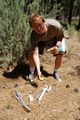
Michael nervously examines the sun-bleached bones of geohashers that came before.
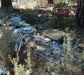
An unfortunate trash heap near the hashpoint.

Mrs.5000 at the hashpoint.
Michael5000 opens his birthday present.
Michael's present, an object d'art, hangs briefly in the woods.
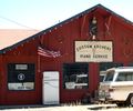
Small town business enterprise in Southern Oregon


Achievements
Michael5000 and Mrs.5000 earned the Graticule Unlocked Achievement
|
Michael5000 earned the Birthday Geohash Achievement
|