Difference between revisions of "2010-08-13 52 1"
imported>Sourcerer (→Expedition) |
imported>Sourcerer m |
||
| Line 28: | Line 28: | ||
Image:2010-08-13_52_1_GogleEarth.jpg |Google Earth Evidence. | Image:2010-08-13_52_1_GogleEarth.jpg |Google Earth Evidence. | ||
</gallery> | </gallery> | ||
| + | |||
| + | [[Category: Meetup on 2010-08-13]] | ||
| + | [[Category: Meetup in 52 1]] | ||
== GPS Evidence == | == GPS Evidence == | ||
Revision as of 19:46, 28 August 2010
Location
In a wheat field near Alburgh west of Bungay, Suffolk, United Kingdom. The hash point was about 80 metres from a public footpath path and easy to get to. There is a GPS path here at wikiloc.
| Fri 13 Aug 2010 in Norwich: 52.4590373, 1.3103065 geohashing.info google osm bing/os kml crox |
Participants
Expedition
Sourcerer (Neil) went meteor spotting at midnight. He spent about 20 minutes at the hashpoint and saw several trails from the Perseid meteor storm before the sky began to get hazy. There had been heavy showers all day so the clear sky was a bonus. The temperature was about 13 Celsius and there was little wind. The moon had set much earlier so the sky was full of stars and as clear as it ever gets in this region of the UK. As a bonus, Neil claims a Midnight Geohash for this expedition.
Image Gallery
The Google Earth image fails to capture the midnight darkness actually experienced.
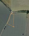
Google Earth Evidence.

GPS Evidence
Here is an extract from Neil's GPX XML file. Local time was midnight. GMT/UTC was 23:00.
<trkpt lat="52.459073904901743" lon="1.310334708541632">
<ele>46.76123046875</ele>
</trkpt>
<trkpt lat="52.459047501906753" lon="1.310310987755656">
<ele>47.2418212890625</ele>
</trkpt>
<trkpt lat="52.459047166630626" lon="1.310311742126942">
<ele>46.2806396484375</ele>
</trkpt>