Difference between revisions of "2010-08-16 42 -122"
imported>Michael5000 (→Achievements) |
m (per Renaming Proposal) |
||
| (5 intermediate revisions by 3 users not shown) | |||
| Line 1: | Line 1: | ||
| − | |||
| − | |||
| − | |||
| − | |||
| − | |||
| − | |||
| − | |||
| − | |||
| − | |||
| − | |||
{{meetup graticule | {{meetup graticule | ||
| lat=42 | | lat=42 | ||
| Line 14: | Line 4: | ||
| date=2010-08-16 | | date=2010-08-16 | ||
}} | }} | ||
| − | |||
| − | |||
__NOTOC__ | __NOTOC__ | ||
== Location == | == Location == | ||
| Line 34: | Line 22: | ||
== Photos == | == Photos == | ||
| − | + | <gallery perrow="5"> | |
| − | + | File:2010-08-16 42 -122 Michael5000.jpg|Michael5000 and his tricorder. | |
| − | + | File:2010-08-16 42 -122 Mrs5000.jpg|Another success for Mrs.5000. | |
| − | -- | + | File:2010-08-16 42 -122 View.jpg|View from the hashpoint. |
| − | + | File:2010-08-16 42 -122 Bear.jpg|He knows what you're thinking, and no he doesn't look like a koala. | |
</gallery> | </gallery> | ||
| Line 45: | Line 33: | ||
{{#vardefine:ribbonwidth|800px}} | {{#vardefine:ribbonwidth|800px}} | ||
| − | + | {{Graticule unlocked | |
| − | {{ | ||
| − | |||
| latitude = 42 | | latitude = 42 | ||
| longitude = -122 | | longitude = -122 | ||
| Line 54: | Line 40: | ||
}} | }} | ||
| − | + | {{Regional geohashing | |
| − | + | | name = Michael5000 and Mrs.5000 | |
| − | + | | region = Jackson County, Oregon | |
| + | | count = 2 | ||
| + | | image = M5K Jackson.jpg | ||
| + | }} | ||
[[Category:Expeditions]] | [[Category:Expeditions]] | ||
| − | [[Category:Expeditions with photos]] | + | <!-- [[Category:Expeditions with photos]] --> |
[[Category:Coordinates reached]] | [[Category:Coordinates reached]] | ||
| + | {{location|US|OR|JA}} | ||
Latest revision as of 06:07, 20 March 2024
| Mon 16 Aug 2010 in 42,-122: 42.1611331, -122.6865967 geohashing.info google osm bing/os kml crox |
Location
In the hills south of Ashland, Oregon.
Participants
Expedition
Hoping for a favorable hashpoint in the area, we checked on Monday morning to find the hash just a mile and a half from BigBrother5000's house. After consulting several maps, we drove about a half-mile to the beginning of a trail system -- driving a half-mile sounding more than a little frivilous, but more understandable if you know the kind of terrain that Ashland is built on.
A mile or so of trail walking brought us within 450 feet of the point. From there, it was a bit of a scramble up a steep slope of dry forest, dodging poison oak and admiring the great madrona trees. We reached the hashpoint without a great deal of trouble or fanfare. We took a few photos, and our minds turned to breakfast.
Photos
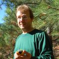
Michael5000 and his tricorder.

Another success for Mrs.5000.
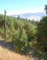
View from the hashpoint.

He knows what you're thinking, and no he doesn't look like a koala.


Achievements
Michael5000 and Mrs.5000 earned the Graticule Unlocked Achievement
|
Michael5000 and Mrs.5000 earned the Regional geohashing achievement
|