Difference between revisions of "2010-08-21 67 25"
From Geohashing
imported>Isopekka (Created page with '{{subst:Expedition |lat = 67 |lon = 25 |date = 2010-08-21 }} {{meetup graticule | lat= 67 | lon= 25 | date=2010-08-21 | graticule_name=Unarin-Luusua, Finland | graticule_link=U…') |
m (per Renaming Proposal) |
||
| (11 intermediate revisions by 4 users not shown) | |||
| Line 1: | Line 1: | ||
| − | + | [[Image:Geohäsläys4 013.JPG|thumb|left]] | |
| − | |||
| − | |||
| − | [[Image: | ||
| − | |||
| − | |||
| − | |||
| − | |||
| − | |||
| − | |||
{{meetup graticule | {{meetup graticule | ||
| lat=67 | | lat=67 | ||
| Line 15: | Line 6: | ||
}} | }} | ||
| − | |||
| − | |||
== Location == | == Location == | ||
| − | + | About 60 km north of Rovaniemi, in wilderness. Can be almost reached by car. | |
| + | |||
== Participants == | == Participants == | ||
| − | + | * [[User:isopekka|isopekka]] with wife, son and dog. | |
| − | |||
| − | |||
== Expedition == | == Expedition == | ||
| − | + | After driving about 90 km my wife and son decided to enjoy the nature in wilderness. So I had to continue driving alone still about 2 km. To the hashpoint I had to walk 800 m. At hashpoint I was at 15:00 p.m. Silence in wilderness was perfect. After hash-documentation I found my family really enjoying outdoor life. | |
| + | |||
| + | * By car total 188 km | ||
| + | * Walking total 1.6 km | ||
| + | * Expedition took 5 hours | ||
| + | * Physical efforts needed(1-5): 2 | ||
| − | |||
| − | |||
| − | == Photos == | + | == Photos == |
| − | |||
| − | |||
| − | |||
<gallery perrow="5"> | <gallery perrow="5"> | ||
| + | Image:Geohäsläys4 001.JPG| The Owl (Surnia ulula?) | ||
| + | Image:Geohäsläys4 003.JPG | Still 2 km to drive | ||
| + | Image:Geohäsläys4 012.JPG| ...and 800 m to walk | ||
| + | Image:Geohäsläys4 004.JPG| Exactly at the latitude N67 | ||
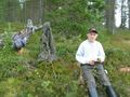
| + | Image:Geohäsläys4 005.JPG | The proof | ||
| + | Image:Geohäsläys4 007.JPG| The hashpoint tree | ||
| + | Image:Geohäsläys4 010.JPG| View from the hashpoint | ||
| + | Image:Geohäsläys4 011.JPG| Another view from the hashpoint | ||
| + | Image:Geohäsläys4 014.JPG| Enjoying the nature | ||
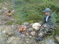
| + | Image:Geohäsläys4 013.JPG| ...and hunting | ||
| + | Image:Geohäsläys4 016.JPG| Kunettijärvi, a nice wilderness lake near the hashpoint | ||
</gallery> | </gallery> | ||
| + | |||
== Achievements == | == Achievements == | ||
| − | |||
| − | |||
| + | {{land geohash | ||
| − | + | | latitude = 67 | |
| − | + | | longitude = 25 | |
| − | + | | date = 2010-08-21 | |
| + | | name = isopekka | ||
| + | |||
| + | }} | ||
| − | + | {{Graticule unlocked | |
| − | + | | latitude = 67 | |
| − | + | | longitude = 25 | |
| − | + | | date = 2010-08-21 | |
| + | | name = isopekka | ||
| + | }} | ||
| − | + | {{minesweeper geohash | name=isopekka | ranknumber=2 | graticule=Rovaniemi, Finland | e=true| n=true }} | |
| − | |||
| − | |||
| − | |||
| − | |||
| − | |||
| − | |||
| − | |||
| − | |||
| − | |||
| − | |||
| − | |||
| − | |||
| − | |||
| − | |||
| − | |||
| − | |||
| − | |||
| − | |||
| + | == Other Geohashing Expeditions and Plans on This Day == | ||
| + | {{expedition summaries|2010-08-21}} | ||
| − | |||
| − | |||
| − | |||
| − | |||
| − | |||
| − | |||
| − | |||
| − | |||
| − | |||
| − | |||
| − | |||
| − | |||
| − | |||
| − | |||
| − | |||
| − | |||
| − | |||
| − | |||
| − | |||
| − | |||
| − | |||
| − | |||
| − | |||
| − | |||
| − | |||
| Line 107: | Line 70: | ||
[[Category:Expeditions with photos]] | [[Category:Expeditions with photos]] | ||
[[Category:Coordinates reached]] | [[Category:Coordinates reached]] | ||
| − | + | {{location|FI|10}} | |
| − | |||
| − | |||
| − | |||
Latest revision as of 06:06, 20 March 2024

| Sat 21 Aug 2010 in 67,25: 67.0014348, 25.7931139 geohashing.info google osm bing/os kml crox |
Contents
Location
About 60 km north of Rovaniemi, in wilderness. Can be almost reached by car.
Participants
- isopekka with wife, son and dog.
Expedition
After driving about 90 km my wife and son decided to enjoy the nature in wilderness. So I had to continue driving alone still about 2 km. To the hashpoint I had to walk 800 m. At hashpoint I was at 15:00 p.m. Silence in wilderness was perfect. After hash-documentation I found my family really enjoying outdoor life.
- By car total 188 km
- Walking total 1.6 km
- Expedition took 5 hours
- Physical efforts needed(1-5): 2
Photos
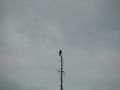
The Owl (Surnia ulula?)
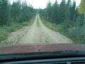
Still 2 km to drive
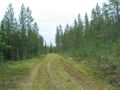
...and 800 m to walk
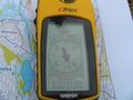
Exactly at the latitude N67
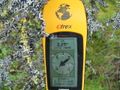
The proof
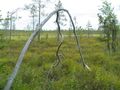
The hashpoint tree
View from the hashpoint
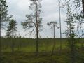
Another view from the hashpoint
Enjoying the nature
...and hunting
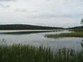
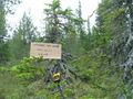
Kunettijärvi, a nice wilderness lake near the hashpoint


Achievements
isopekka earned the Land geohash achievement
|
isopekka earned the Graticule Unlocked Achievement
|
isopekka achieved level 2 of the Minesweeper Geohash achievement
|
Other Geohashing Expeditions and Plans on This Day
Expeditions and Plans
| 2010-08-21 | ||
|---|---|---|
| Paducah, Kentucky | Spork | Near Massac, KY |
| Atlantic City, New Jersey | Jevanyn, Gwynnath, Evan | It looks like an empty lot on Surf Dr., in North Wildwood. Landward side b... |
| Boston, Massachusetts | Wwwi7891 | The Buck Hill Management Area in Pascoag, RI. Relatively secluded public wo... |
| Manitowoc, Wisconsin | Bassoon, Dedehawk, PainJain | In a church near St. Nazianz, Wisconsin. |
| Seattle, Washington | OtherJack | On a suburban streetside in Lacey, WA (near Olympia) |
| North Cascades National Park, Washington | AeroIllini | Our first attempt was made at a turnoff on Woods Creek Rd. The sign at the ... |
| Calgary NE, Alberta | air384, Chris, Brett | On the side of Range Road 235A, near the fence. |
| Esbjerg, Denmark | Ekorren, dawidi, AE, Schorhr | Ekorren started in Stuttgart not long after midnight and rode intercity tra... |
| Gjøvik, Norway | Blóðøx, Snoken | Woodland, just north of Oslo. |
| Unarin-Luusua, Finland | isopekka, son, dog. | About 60 km north of Rovaniemi, in wilderness. Can be almost reached by car... |