Difference between revisions of "2010-08-22 66 26"
From Geohashing
imported>Isopekka (→Expedition) |
imported>FippeBot m (Location) |
||
| (3 intermediate revisions by one other user not shown) | |||
| Line 1: | Line 1: | ||
<!-- If you did not specify these parameters in the template, please substitute appropriate things for IMAGE, LAT, LON, and DATE (YYYY-MM-DD format) | <!-- If you did not specify these parameters in the template, please substitute appropriate things for IMAGE, LAT, LON, and DATE (YYYY-MM-DD format) | ||
| − | + | ||
Remove this section if you don't want a image at the top (left) of your report. You should remove the "Image:" or "File:" | Remove this section if you don't want a image at the top (left) of your report. You should remove the "Image:" or "File:" | ||
| Line 8: | Line 8: | ||
And DON'T FORGET to add your expedition and the best photo you took to the gallery on the Main Page! We'd love to read your report, but that means we first have to discover it! | And DON'T FORGET to add your expedition and the best photo you took to the gallery on the Main Page! We'd love to read your report, but that means we first have to discover it! | ||
--> | --> | ||
| + | [[Image:Geohäsläys5 008.JPG|thumb|left]] | ||
| + | |||
{{meetup graticule | {{meetup graticule | ||
| lat=66 | | lat=66 | ||
| Line 41: | Line 43: | ||
* Expedition took 3 hours | * Expedition took 3 hours | ||
* Physical efforts needed(1-5): 1 | * Physical efforts needed(1-5): 1 | ||
| + | |||
==Photos == | ==Photos == | ||
| Line 55: | Line 58: | ||
</Gallery> | </Gallery> | ||
| + | |||
== Achievements == | == Achievements == | ||
| + | |||
| + | {{land geohash | ||
| + | |||
| + | | latitude = 66 | ||
| + | | longitude = 26 | ||
| + | | date = 2010-08-22 | ||
| + | | name = isopekka | ||
| + | |||
| + | }} | ||
{{consecutive geohash | {{consecutive geohash | ||
| Line 70: | Line 83: | ||
| + | == Other Geohashing Expeditions and Plans on This Day == | ||
| − | + | {{expedition summaries|2010-08-22}} | |
| − | |||
| − | |||
| − | |||
| − | |||
| − | |||
| − | |||
| − | |||
| Line 87: | Line 94: | ||
[[Category:Expeditions with photos]] | [[Category:Expeditions with photos]] | ||
[[Category:Coordinates reached]] | [[Category:Coordinates reached]] | ||
| + | {{location|FI|10}} | ||
Latest revision as of 03:26, 9 August 2019

| Sun 22 Aug 2010 in 66,26: 66.3619455, 26.4124052 geohashing.info google osm bing/os kml crox |
Contents
Location
About 35 km SE from the city of Rovaniemi, Finland. About 4 km souththeast from the village Jokela.
Plan
At the same time geohashing and water bird hunting.
Participants
- isopekka & Son
Expedition
50 km driving and the hashpoint was very near the narrow road, on the shore of small wilderness lake. One lonely swan was in silency watching my hashing (at 3:00 p.m.). Expedition succeeded, but hunting not. We saw one goldeneye, but could not get it down...
- By car total 100 km
- Walking total 0.1 km
- Expedition took 3 hours
- Physical efforts needed(1-5): 1
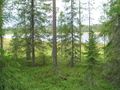
Photos
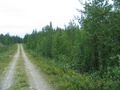
Hashpoint is in the middle of the photo
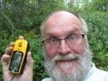
Hashman
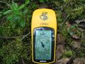
The Proof
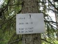
Hashpoint marked
View from the hashpoint
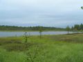
On the shore of the hashpoint lake
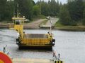
On the way home
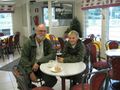
Happy hunters after the expedition


Achievements
isopekka earned the Land geohash achievement
|
isopekka earned the Consecutive geohash achievement
|
Other Geohashing Expeditions and Plans on This Day
Expeditions and Plans
| 2010-08-22 | ||
|---|---|---|
| Leipzig, Germany | Ekorren, dawidi | Somewhere in Leipzigs green parts. |
| Malmö, Sweden | Fasanen | Beddingestrand, Sweden. Open terrain just a meter from a gravel road. |
| Turku, Finland | team pson | at Island of Kirjala thats in Parainen/Pargas, Almost reached by team_pson.... |
| Vanttauskoski, Finland | isopekka | About 35 km SE from the city of Rovaniemi, Finland. About 4 km souththeast ... |