Difference between revisions of "2010-08-27 35 -106"
imported>Redaragorn (→Pictures) |
imported>FippeBot m (Location) |
||
| (One intermediate revision by one other user not shown) | |||
| Line 18: | Line 18: | ||
== Expedition == | == Expedition == | ||
| − | Got in a long run this morning, then ran some errands before heading down to attempt the hash. I wasn't quite sure what tack I would take to try to get access to the golf course, but it turns out that I didn't need to worry much. I walked right onto the course. I followed the dirt track by the fence to skirt around the course to the 12th hole. A group was just teeing up as I approached, so I discreetly followed them down the hole until they'd moved on to their third shot. I saw another group teeing up so I knew I didn't have a whole lot of time, but I wandered onto the fairway with my GPS and camera out to get my shots. Mission accomplished, I backtracked to the clubhouse and parking lot before heading on with the rest of my day. Yay! | + | Got in a long run this morning, then ran some errands before heading down to attempt the hash. I wasn't quite sure what tack I would take to try to get access to the golf course, but it turns out that I didn't need to worry much. I walked right onto the course. I also wasn't sure how I was going to get a golf ball to drop onto the green, but as I was walking in to the course, I ran into a friend just finishing up a round of golf. Cool! I borrowed one of his balls for the occasion and went on with my geohashing. I followed the dirt track by the fence to skirt around the course to the 12th hole. A group was just teeing up as I approached, so I discreetly followed them down the hole until they'd moved on to their third shot. I saw another group teeing up so I knew I didn't have a whole lot of time, but I wandered onto the fairway with my GPS and camera out to get my shots. Mission accomplished, I backtracked to the clubhouse and parking lot before heading on with the rest of my day. Yay! |
== Track == | == Track == | ||
| Line 43: | Line 43: | ||
[[Category:Expeditions]] | [[Category:Expeditions]] | ||
[[Category:Coordinates reached]] | [[Category:Coordinates reached]] | ||
| + | {{location|US|NM|BE}} | ||
Latest revision as of 03:27, 9 August 2019
| Fri 27 Aug 2010 in 35,-106: 35.1153495, -106.7117253 geohashing.info google osm bing/os kml crox |
Location
Right on the fairway of hole 12 at Ladera Golf Course on the west side of Albuquerque.
Participants
Plans
Today is my birthday, and I have off work. Of course I'm gonna try for the hash! And look, it's a) close and b) on a golf course. Cool!
Expedition
Got in a long run this morning, then ran some errands before heading down to attempt the hash. I wasn't quite sure what tack I would take to try to get access to the golf course, but it turns out that I didn't need to worry much. I walked right onto the course. I also wasn't sure how I was going to get a golf ball to drop onto the green, but as I was walking in to the course, I ran into a friend just finishing up a round of golf. Cool! I borrowed one of his balls for the occasion and went on with my geohashing. I followed the dirt track by the fence to skirt around the course to the 12th hole. A group was just teeing up as I approached, so I discreetly followed them down the hole until they'd moved on to their third shot. I saw another group teeing up so I knew I didn't have a whole lot of time, but I wandered onto the fairway with my GPS and camera out to get my shots. Mission accomplished, I backtracked to the clubhouse and parking lot before heading on with the rest of my day. Yay!
Track
Accidentally erased the GPS track. :-(( I walked about 1.3 mi total.
Pictures
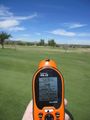
GPS coordinates

beautiful sky grin

Golf ball on the hashpoint
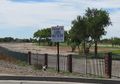
Golf Course sign (open to the public!)

Driver's license to prove the birthday hash


Achievements
redaragorn earned the Birthday Geohash Achievement
|
redaragorn earned the Golf Geohash Achievement
|