Difference between revisions of "2010-09-01 -36 174"
imported>Greenslime m |
imported>FippeBot m (Location) |
||
| (7 intermediate revisions by 2 users not shown) | |||
| Line 14: | Line 14: | ||
}} | }} | ||
| − | + | ||
__NOTOC__ | __NOTOC__ | ||
== Location == | == Location == | ||
| − | Golf course | + | Waitemata Golf course, Devonport Peninsula, North Shore City, Auckland |
== Participants == | == Participants == | ||
| Line 23: | Line 23: | ||
== Plans == | == Plans == | ||
| − | This hash | + | This hash isn't too far from my house. Will go home after work and pick up camera, compass and running gear (multi-task potential), and drive down to the golf course. Take a bearing of 270 degrees from the driveway of 32 Wairoa, and wander along this bearing until I reach the path shown in satellite image below. |
| + | |||
| + | Hoping there will be no fences to thwart this effort like on other [[2010-08-07 -36 174|occassions]] | ||
== Expedition == | == Expedition == | ||
| − | + | Picked up camera and compass. Drove to destination, took bearing a followed it. There wasn't a fence around the golf course, instead there was a ditch where I almost got my new bright white running shoes dirty (catastrophe averted however). Ambled along the golf course to the intersection of the tracks, as seen in the google map. I aligned myself at the correct spot and took a photo of my shadow. Was around 16:30 so the shadow shows me to be much taller than I actually am. Hash achieved, and i didnt even seem to draw any unwanted attention from the golfers. No balls came my way either. Back to the car and off for a run to Mt Victoria and back, with token photo of Auckland taken from the top. Nice easy hash. | |
== Tracklog == | == Tracklog == | ||
| Line 35: | Line 37: | ||
Image:20100901_-36_174_Hash.JPG|This is Auckland, lucky this landed on land | Image:20100901_-36_174_Hash.JPG|This is Auckland, lucky this landed on land | ||
Image:20100901 -36 174 Bearing.JPG|Hoping for no fences, but hoping for golf balls | Image:20100901 -36 174 Bearing.JPG|Hoping for no fences, but hoping for golf balls | ||
| + | Image:2010-09-01 -36 174 Gully.jpg|No fences, but this gully instead | ||
| + | Image:2010-09-01 -36 174 Intersection.jpg|Intersection of tracks by hash point seen in satellite image | ||
| + | Image:2010-09-01 -36 174 Hash Point.jpg|Hash point, could be anywhere.... | ||
| + | Image:2010-09-01_-36_174_Waitemata_Golf_Club.jpg|Signage | ||
| + | Image:2010-09-01 -36 174 Mt Victoria.jpg|Proceeded to run from here up this big hill (Mt Victoria) | ||
| + | Image:2010-09-01 -36 174 Auckland at Sunset.jpg|This is Auckland. View from the top of Mt Vic | ||
</gallery> | </gallery> | ||
| Line 40: | Line 48: | ||
{{#vardefine:ribbonwidth|800px}} | {{#vardefine:ribbonwidth|800px}} | ||
<!-- Add any achievement ribbons you earned below, or remove this section --> | <!-- Add any achievement ribbons you earned below, or remove this section --> | ||
| − | + | {{consecutive geohash | |
| − | + | | count = 2 | |
| − | + | | latitude = -36 | |
| − | + | | longitude = 174 | |
| − | [[ | + | | date = 2010-08-31 |
| − | [[ | + | | name = [[User:Greenslime|Greenslime]] |
| − | + | }} | |
| − | + | {{No_batteries_geohash | latitude = -36 | longitude = 174 | date = 2010-09-01 | name = [[User:Greenslime|Greenslime]]}} | |
| − | |||
[[Category:Expeditions]] | [[Category:Expeditions]] | ||
| − | |||
[[Category:Expeditions with photos]] | [[Category:Expeditions with photos]] | ||
| − | |||
[[Category:Expedition without GPS]] | [[Category:Expedition without GPS]] | ||
| − | |||
| − | |||
| − | |||
[[Category:Coordinates reached]] | [[Category:Coordinates reached]] | ||
| − | + | {{location|NZ|AUK}} | |
| − | |||
| − | |||
| − | |||
| − | |||
| − | |||
| − | |||
| − | |||
| − | |||
| − | |||
Latest revision as of 03:33, 9 August 2019
| Wed 1 Sep 2010 in -36,174: -36.8186082, 174.8009115 geohashing.info google osm bing/os kml crox |
Location
Waitemata Golf course, Devonport Peninsula, North Shore City, Auckland
Participants
Plans
This hash isn't too far from my house. Will go home after work and pick up camera, compass and running gear (multi-task potential), and drive down to the golf course. Take a bearing of 270 degrees from the driveway of 32 Wairoa, and wander along this bearing until I reach the path shown in satellite image below.
Hoping there will be no fences to thwart this effort like on other occassions
Expedition
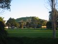
Picked up camera and compass. Drove to destination, took bearing a followed it. There wasn't a fence around the golf course, instead there was a ditch where I almost got my new bright white running shoes dirty (catastrophe averted however). Ambled along the golf course to the intersection of the tracks, as seen in the google map. I aligned myself at the correct spot and took a photo of my shadow. Was around 16:30 so the shadow shows me to be much taller than I actually am. Hash achieved, and i didnt even seem to draw any unwanted attention from the golfers. No balls came my way either. Back to the car and off for a run to Mt Victoria and back, with token photo of Auckland taken from the top. Nice easy hash.
Tracklog
Photos
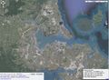
This is Auckland, lucky this landed on land
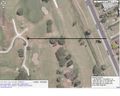
Hoping for no fences, but hoping for golf balls
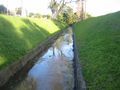
No fences, but this gully instead
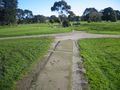
Intersection of tracks by hash point seen in satellite image
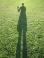
Hash point, could be anywhere....
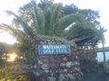
Signage
Proceeded to run from here up this big hill (Mt Victoria)
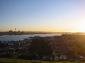
This is Auckland. View from the top of Mt Vic


Achievements
Greenslime earned the Consecutive geohash achievement
|
Greenslime earned the No Batteries Geohash Achievement
|