Difference between revisions of "2010-09-04 52 0"
imported>Sourcerer (Created page with '== Location == In a sugar beet field east of Royston. {{meetup graticule | lat=52 | lon=0 | date=2010-09-04 | graticule_name=Cambridge | graticule_link=Cambridge, United Kingdo…') |
imported>Sourcerer |
||
| Line 24: | Line 24: | ||
Image:2010-09-04_52_0_Sourcerer_GE.jpg|Google Earth Close Up | Image:2010-09-04_52_0_Sourcerer_GE.jpg|Google Earth Close Up | ||
Image:2010-09-04_Sourcerer_GE_All.jpg|Google Earth Path for all four hash points. | Image:2010-09-04_Sourcerer_GE_All.jpg|Google Earth Path for all four hash points. | ||
| + | </gallery> | ||
| + | |||
| + | == More Proof == | ||
| + | |||
| + | I have a gdb file from my Garmin GPS receiver. I used GPSBabel to convert it to GPX/XML format. Here is the trackpoint for the geohash. The time-stamp is in GMT. | ||
| − | </ | + | <pre> |
| + | <trkpt lat="52.044831700623035" lon="0.012634210288525"> | ||
| + | <ele>64.0650634765625</ele> | ||
| + | <time>2010-09-04T16:38:01Z</time> | ||
| + | </trkpt> | ||
| + | </pre> | ||
[[Category:Meetup on 2010-09-04]] | [[Category:Meetup on 2010-09-04]] | ||
Revision as of 23:56, 4 September 2010
Location
In a sugar beet field east of Royston.
| Sat 4 Sep 2010 in Cambridge: 52.0448326, 0.0126721 geohashing.info google osm bing/os kml crox |
Participants
Expedition
Sourcerer (Neil) spotted that the hash point was only 850 metres east of the Greenwich Meridian and there was another hashpoint 850 metres west. This was the ideal opportunity to collect two easy hashes close to each other. The hash was reached from a layby on the main A505 road. To reach the hash, there was a short walk along the Icknield way and then onto a farm track. A bit of tip toeing in the sugar beet was needed. The plants were still small enough to do this without damage. This was point 4 of a quad hash. The Google Earth image shows wheat growing in an earlier year.
Image Gallery
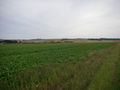
Sugar Beet
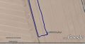
Google Earth Close Up
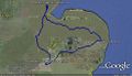
Google Earth Path for all four hash points.


More Proof
I have a gdb file from my Garmin GPS receiver. I used GPSBabel to convert it to GPX/XML format. Here is the trackpoint for the geohash. The time-stamp is in GMT.
<trkpt lat="52.044831700623035" lon="0.012634210288525">
  <ele>64.0650634765625</ele>
  <time>2010-09-04T16:38:01Z</time>
</trkpt>