Difference between revisions of "2010-09-04 53 -0"
imported>Sourcerer m |
imported>Sourcerer |
||
| Line 1: | Line 1: | ||
| − | |||
| − | |||
| − | |||
| − | |||
{{meetup graticule | {{meetup graticule | ||
| lat=53 | | lat=53 | ||
| Line 8: | Line 4: | ||
| date=2010-09-04 | | date=2010-09-04 | ||
| graticule_name=Hull | | graticule_name=Hull | ||
| − | | graticule_link=Hull, United Kingdom}} | + | | graticule_link=Hull, United Kingdom |
| + | }} | ||
| + | |||
| + | == Location == | ||
| + | |||
| + | In a sweet corn field just north west of the village of Sibsey. The nearest town was Boston (Lincolnshire, UK). | ||
== Participants == | == Participants == | ||
| Line 20: | Line 21: | ||
== Image Gallery == | == Image Gallery == | ||
| − | <gallery | + | <gallery> |
Image:2010-09-04_53_-0_Sourcerer_GE.jpg|Google Earth Path | Image:2010-09-04_53_-0_Sourcerer_GE.jpg|Google Earth Path | ||
Image:2010-09-04_53_-0_Sourcerer-a.JPG|Sweet Corn Field | Image:2010-09-04_53_-0_Sourcerer-a.JPG|Sweet Corn Field | ||
| Line 43: | Line 44: | ||
{{expedition summaries|2010-09-04}} | {{expedition summaries|2010-09-04}} | ||
| − | |||
| − | |||
[[Category:Expeditions]] | [[Category:Expeditions]] | ||
[[Category:Coordinates reached]] | [[Category:Coordinates reached]] | ||
[[Category:Expeditions with photos]] | [[Category:Expeditions with photos]] | ||
Revision as of 14:41, 22 August 2012
| Sat 4 Sep 2010 in Hull: 53.0448326, -0.0126721 geohashing.info google osm bing/os kml crox |
Contents
Location
In a sweet corn field just north west of the village of Sibsey. The nearest town was Boston (Lincolnshire, UK).
Participants
Expedition
Sourcerer (Neil) spotted that the hash point was only 850 metres west of the Greenwich Meridian and there was another hashpoint 850 metres east. This was the ideal opportunity to collect two easy hashes within walking distance of each other. In the end he didn't walk because the siren call of a Bateman's pub was too strong. This involved a small detour by car. After that he needed petrol. For this hash point he only walked about 3.2km. There were red deer hiding in the wood next to the hash point.
Image Gallery
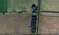
Google Earth Path
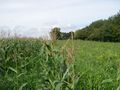
Sweet Corn Field
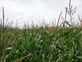
Sweet Corn Field
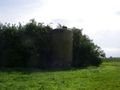
Silo Landmark Nearby
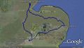
Google Earth Path for all four hash points.


More Proof
I have a gdb file from my Garmin GPS receiver. I used GPSBabel to convert it to GPX/XML format. Here is the trackpoint for the geohash. The time-stamp is in GMT.
<trkpt lat="53.044841615483165" lon="-0.012521054595709">
  <ele>0.6180419921875</ele>
  <time>2010-09-04T13:51:15Z</time>
</trkpt>
Other geohashing expeditions on the same day
Expeditions and Plans
| 2010-09-04 | ||
|---|---|---|
| McMinnville, Oregon | Jim | Off a highway near Salem down a steep embankment. |
| Schweinfurt, Germany | Danatar | in a harvested corn field near Burghausen, a part of Wasserlosen. Country:... |
| Kielce, Poland | Felinator | In the middle of river Wisła (Vistula) in Kraków, near power plant Łęg. |
| Northampton, United Kingdom | Sourcerer | 3) In a residential street in Royston, Hertfordshire, UK. |
| Cambridge, United Kingdom | Sourcerer | 4) In a sugar beet field east of Royston, Hertfordshire, UK. |
| Utrecht, Netherlands | CO2, Freeze XJ | In between Montfoort en IJsselstein, in a piece of farmland, probably priva... |
| Hull, United Kingdom | Sourcerer | 2) In a sweet corn field just north west of the village of Sibsey. The near... |
| Skegness, United Kingdom | Sourcerer | 1) In a harvested wheat field just north of the village of Sibsey. The near... |