Difference between revisions of "2010-09-17 53 9"
imported>Seamus d |
imported>Mtu |
||
| Line 1: | Line 1: | ||
| + | {{MtuClustermug | ||
| + | | lat=53 | ||
| + | | lon=9 | ||
| + | | date=2010-09-17 | ||
| + | }} | ||
| + | |||
[[Image:{{{image|2010-09-17_53_9--sign.jpg}}}|thumb|left|Don't worry!]] | [[Image:{{{image|2010-09-17_53_9--sign.jpg}}}|thumb|left|Don't worry!]] | ||
{{meetup graticule | {{meetup graticule | ||
Revision as of 21:52, 13 November 2010
In all cases, the actual hashpoints would have been easily accessible, but were missed by 20–200 m solely due to mtu's ineptitude.
In commemoration of this epic fail,
mtu earned the False Start Consolation Prize
|
As a consequence, all achievements formerly claimed for this hash are null and void (except Drag-along achievements). Instead,
mtu earned the Blinded by Science Consolation Prize
|
Please note that the expedition narrative was written before this became known!

| Fri 17 Sep 2010 in 53,9: 53.2096077, 9.8750724 geohashing.info google osm bing/os kml crox |
Location
Geohash located in a nature reserve area about 3 to 4 kilometers south of Handeloh, a one-horse town of about 2,400 inhabitants, luckily and inexplicably featuring a HVV area railroad stop. Apparently also right next to a place called Wehlen, about which there is no information to be found except for the name on the map and the curious fact that the entire place appears to consist of one street.
In short: Right smack bang in the middle of frickin' nowhere.
Participants
Expedition
The Handeloh train station is the outermost of the HVV area in the direction of Soltau, allowing us to get there for free. After almost missing our connection train, and then almost missing our stop, we set out from the empty place we were in for the even more empty place where the hash was.
Our trip was pretty uneventful (except for a scary sounding machine that was cutting trees – who's cutting trees in a natural preserve area, anyway?!), but relaxing and fun. When we got to the hash, we took some pictures, left a note, drank a beer and then headed back. An attempt to live edit the wiki failed due to non-existent network coverage in the area.
We took a different route back, but to our amazement, things looked pretty much the same as they had on the way in. After having passed about eight people on our 11 km trip, we got back to the train station and headed home as happy first-time geohashers.
Tracklog

Tracklog in GPX 1.1 format (XML Document) accessible in a pastebin.ca post.
Photos
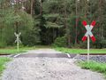
Safety first!
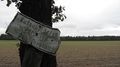
“No horse carriage rides – The forestry office”
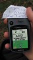
Photo finish
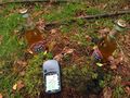
My, look what grows here!
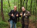
Stupid Grin™ permutation 0
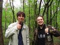
Stupid Grin™ permutation 1
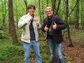
Stupid Grin™ permutation 2
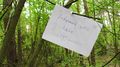
Please leave a message!


Achievements
mtu earned the Land geohash achievement
|
mtu earned the Public transport geohash achievement
|
mtu earned the Drag-along achievement
|