2010-09-24 51 1
From Geohashing
Revision as of 17:48, 21 November 2010 by imported>Sourcerer (→Photo Gallery)
Location
Hash 1 of 5: About a mile east of the village of East Bergholt and just south of the A12. It was in a sheep field.
| Fri 24 Sep 2010 in Canterbury: 51.9829422, 1.0410459 geohashing.info google osm bing/os kml crox |
Participants
Sourcerer - Arrived at about 18:56
MagicIan - Arrived somewhat later and did not meet Sourcerer.
Expedition
Sourcerer (Neil) made a 300 mile journey and took in five hashpoints. This was the first. It was a straightforward circular country walk past fields, across a stream and through a wood.
Tracklog
The track is logged here at Wikiloc.
Photo Gallery
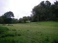
Sheep Field at Dusk
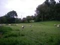
Sheep Field at Dusk
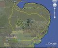
Google Earth Image
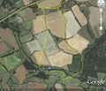
Google Earth Walk Track


Achievements
Neil believes this is the first documented expedition in the Canterbury graticule. It seems odd to claim this by visiting a point in Suffolk.