Difference between revisions of "2010-09-26 66 25"
imported>Isopekka (→Expedition) |
imported>FippeBot m (Location) |
||
| (6 intermediate revisions by one other user not shown) | |||
| Line 1: | Line 1: | ||
<!-- If you did not specify these parameters in the template, please substitute appropriate things for IMAGE, LAT, LON, and DATE (YYYY-MM-DD format) | <!-- If you did not specify these parameters in the template, please substitute appropriate things for IMAGE, LAT, LON, and DATE (YYYY-MM-DD format) | ||
| − | [[Image: | + | [[Image:Geh8 007.JPG|thumb|left]] |
Remove this section if you don't want a image at the top (left) of your report. You should remove the "Image:" or "File:" | Remove this section if you don't want a image at the top (left) of your report. You should remove the "Image:" or "File:" | ||
| Line 8: | Line 8: | ||
And DON'T FORGET to add your expedition and the best photo you took to the gallery on the Main Page! We'd love to read your report, but that means we first have to discover it! | And DON'T FORGET to add your expedition and the best photo you took to the gallery on the Main Page! We'd love to read your report, but that means we first have to discover it! | ||
--> | --> | ||
| + | [[Image:Geh8 007.JPG|thumb|left]] | ||
| + | |||
{{meetup graticule | {{meetup graticule | ||
| lat=66 | | lat=66 | ||
| Line 13: | Line 15: | ||
| date=2010-09-26 | | date=2010-09-26 | ||
}} | }} | ||
| − | |||
| − | |||
| Line 49: | Line 49: | ||
The path can be found at [http://www.wikiloc.com/wikiloc/view.do?id=1200598 WikiLoc] | The path can be found at [http://www.wikiloc.com/wikiloc/view.do?id=1200598 WikiLoc] | ||
| + | |||
| + | |||
==Photos == | ==Photos == | ||
| Line 63: | Line 65: | ||
</Gallery> | </Gallery> | ||
| + | |||
| + | |||
== Achievements == | == Achievements == | ||
| + | |||
| + | {{land geohash | ||
| + | |||
| + | | latitude = 66 | ||
| + | | longitude = 25 | ||
| + | | date = 2010-09-26 | ||
| + | | name = isopekka | ||
| + | }} | ||
{{Tron | {{Tron | ||
| Line 72: | Line 84: | ||
| longitude = 25 | | longitude = 25 | ||
| date = 2010-09-26 | | date = 2010-09-26 | ||
| − | | tracklog = http:// | + | | tracklog = http://www.wikiloc.com/wikiloc/view.do?id=1200598 |
| possessive = his | | possessive = his | ||
| name = isopekka | | name = isopekka | ||
| Line 81: | Line 93: | ||
{{gratuitous ribbon | {{gratuitous ribbon | ||
| + | | icon = 72px finish line.png | ||
| latitude = 66 | | latitude = 66 | ||
| longitude = 25 | | longitude = 25 | ||
| Line 87: | Line 100: | ||
| description = driving with maximum possible velocity almost through the | | description = driving with maximum possible velocity almost through the | ||
| name = isopekka | | name = isopekka | ||
| − | | image = | + | | image = 72px finish line.png |
| − | }} | + | }} |
| + | |||
| + | |||
| + | |||
| + | == Other Geohashing Expeditions and Plans on This Day == | ||
| + | |||
| + | {{expedition summaries|2010-09-26}} | ||
| + | |||
[[Category:Expeditions]] | [[Category:Expeditions]] | ||
[[Category:Expeditions with photos]] | [[Category:Expeditions with photos]] | ||
[[Category:Coordinates reached]] | [[Category:Coordinates reached]] | ||
| + | {{location|FI|10}} | ||
Latest revision as of 03:54, 9 August 2019

| Sun 26 Sep 2010 in 66,25: 66.2387915, 25.4192035 geohashing.info google osm bing/os kml crox |
Contents
Location
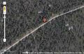
About 50 km SW from Rovaniemi, Finland. Point is on the small road.
Participants
- isopekka & Tintti
Plans
Visit the point and get the speed racer achievement.
Expedition
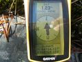
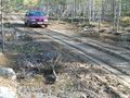
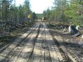
From the map it could be seen, that the point was exactly on the road. That was it why I took this expedition: I could get the speed racer achievement! Last 3.5 kilometers were awful. The road was small muddy forest road and I had to drive very slowly and carefully. Finally we were about at 01:00 p.m. at the hashpoint , which unfortunately situated not on the road, but 3-4 meters aside... no speed racer possibility.
But then I luckily found out, that the Tron achievement was able to reach.
- Walking total 0 km
- By car total about 120 km
- Expedition took 2.5 hours
- Physical efforts needed (1-5): 1
The path can be found at WikiLoc
Photos
This geohash should be on the road!!
The Proof
Geohash marked with wooden marker (on the right corner)
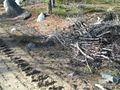
View from the hashpoint
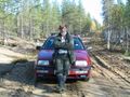
The Hasher
And now back to home...


Achievements
isopekka earned the Land geohash achievement
|
isopekka earned the Tron achievement
|
isopekka earned the Almost speed racer achievement
|
Other Geohashing Expeditions and Plans on This Day
Expeditions and Plans
| 2010-09-26 | ||
|---|---|---|
| Toronto, Ontario | Splitdipless | Somewhere on the bottom of Lake Ontario. So I'm not going to go there... I'... |
| Frankfurt am Main, Germany | Mampfred, LadyBB | in the middle of the nature park Hoch-Taunus, i.e. in the middle of a fores... |
| Gjøvik, Norway | relet | A strip of wood near a field, in Jevnaker. Or maybe in a ditch/creek. |
| Rovaniemi, Finland | isopekka | About 50 km SW from Rovaniemi, Finland. Point is on the small road. |