Difference between revisions of "2010-09-29 55 13"
imported>Fasanen (→Photos) |
imported>Ilpadre (moved 2010-09-29 55 13 1 here) |
||
| Line 10: | Line 10: | ||
Hindby junction, eastern outskirts of Malmö. | Hindby junction, eastern outskirts of Malmö. | ||
| − | == | + | == [[User:Fasanen|Fasanen]] & Ms.C == |
| − | [[User:Fasanen|Fasanen]] & Ms.C | ||
| − | == Plans == | + | === Plans === |
Go there in the morning (around nine o'clock). | Go there in the morning (around nine o'clock). | ||
| Line 20: | Line 19: | ||
Uncertain about this though. It's rated to be 4.5 in terrain! | Uncertain about this though. It's rated to be 4.5 in terrain! | ||
| − | == Expedition == | + | === Expedition === |
I estimated a 90% chance of reaching today’s coordinates. The more interesting question was if I could achieve the [[Hash_collision_achievement | "Hash collision achievement"]] by logging the 4.5-terrain rated geocache [http://www.geocaching.com/seek/cache_details.aspx?guid=98e1e8dc-f32b-48fb-a952-5f0ee6e1bd6d GC1T7M4] just about 30-40 meters north from the hash. But first things first. | I estimated a 90% chance of reaching today’s coordinates. The more interesting question was if I could achieve the [[Hash_collision_achievement | "Hash collision achievement"]] by logging the 4.5-terrain rated geocache [http://www.geocaching.com/seek/cache_details.aspx?guid=98e1e8dc-f32b-48fb-a952-5f0ee6e1bd6d GC1T7M4] just about 30-40 meters north from the hash. But first things first. | ||
| Line 29: | Line 28: | ||
...but Ms.C found some nice flowers and we went to 55 12 and the Öresund bridge where there is a nice view. After eating some cinnamon buns and bananas and doing some light shopping in Malmö, we went back home. | ...but Ms.C found some nice flowers and we went to 55 12 and the Öresund bridge where there is a nice view. After eating some cinnamon buns and bananas and doing some light shopping in Malmö, we went back home. | ||
| − | == Photos == | + | === Photos === |
<gallery perrow=4"> | <gallery perrow=4"> | ||
File:HashCollision551320100929.png | The project. | File:HashCollision551320100929.png | The project. | ||
| Line 39: | Line 38: | ||
Image:551320100929 06.jpg | Öresund bridge (Android HDR) | Image:551320100929 06.jpg | Öresund bridge (Android HDR) | ||
Image:551320100929 07.JPG | Overlooking 55 12 | Image:551320100929 07.JPG | Overlooking 55 12 | ||
| + | </gallery> | ||
| + | |||
| + | == [[User:llavids|llavids]] == | ||
| + | |||
| + | === Plans === | ||
| + | To go there after work hours. Looks quite easy from a satellite photo. | ||
| + | |||
| + | === Expedition === | ||
| + | I went there about 17.15. I almost persuade my colleage to go there with me, but he bailed out. I discovered Fasanen had been there earlier this day! I documented the place and I did not know about the geocache at the sign at that moment. My goal was to reach another geocache on my way home so my stay was short. | ||
| + | |||
| + | === Photos === | ||
| + | |||
| + | <gallery perrow="3"> | ||
| + | Image:100929-Proof.JPG|Proof | ||
| + | Image:100929-Me.JPG|Me at the location | ||
| + | Image:100929-Fasanen-left-his-marker.JPG|Fasanen marker | ||
| + | Image:100929-Hindby.JPG|Hindby junction sign | ||
| + | Image:100929-Surrounding-1.JPG|Surroundings from location | ||
| + | Image:100929-Surrounding-2.JPG|Surroundings from location with Fasanen marker | ||
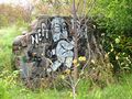
| + | Image:100929-Grafitti.JPG|Grafitti nearby | ||
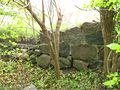
| + | Image:100929-Remains.JPG|House remains nearby | ||
| + | Image:100929-Road-remains.JPG|Road remains nearby | ||
</gallery> | </gallery> | ||
Revision as of 05:44, 1 October 2010
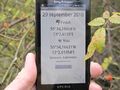
| Wed 29 Sep 2010 in 55,13: 55.5694347, 13.0435584 geohashing.info google osm bing/os kml crox |
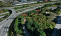
Location
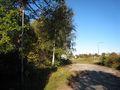
Hindby junction, eastern outskirts of Malmö.
Fasanen & Ms.C
Plans
Go there in the morning (around nine o'clock).
Maybe also try to get the "Hash collision achievement" by finding the extremely close GC1T7M4-cache.
Uncertain about this though. It's rated to be 4.5 in terrain!
Expedition
I estimated a 90% chance of reaching today’s coordinates. The more interesting question was if I could achieve the "Hash collision achievement" by logging the 4.5-terrain rated geocache GC1T7M4 just about 30-40 meters north from the hash. But first things first.
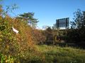
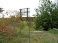
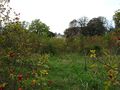
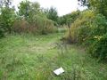
Me and Ms.C got to the Hindby junction about 9.30 am. The general area was a mixture of industrial estate and housing area. The setting of the hash was however overgrown with rose bushes with buildings in very advanced stages of decay. The first attempt to approach to the hash was thwarted by rose shrubs and a bit of marsh. After a flanking movement we found a path that led to the rose bush in which the hash could be registered. I made the usual documentation and left a marker. Now on to the geocache.
The structure where the cache was located, turned out to be a huge advertising sign. It was clearly visible from the hash but it took me some time to locate the actual cache container itself. It was as high up as possible and the terrain rating was not exaggerated. After assessing the situation, I decided to exercise some parental responsibility and sound judgement by not letting my daughter see her father potentially getting badly injured or even die, so and decided to call this achievement a (sad) day...
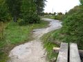
...but Ms.C found some nice flowers and we went to 55 12 and the Öresund bridge where there is a nice view. After eating some cinnamon buns and bananas and doing some light shopping in Malmö, we went back home.
Photos
The project.
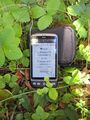
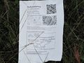
Proof
Hash, Ms.C (lurking in shadows) and the geocache
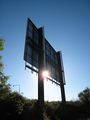
Cache is in the top of the left white pole
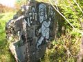
Decay I. What became of this graffiti artist?
Decay II. No more leaning on this lamp post.
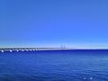
Öresund bridge (Android HDR)
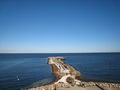
Overlooking 55 12


llavids
Plans
To go there after work hours. Looks quite easy from a satellite photo.
Expedition
I went there about 17.15. I almost persuade my colleage to go there with me, but he bailed out. I discovered Fasanen had been there earlier this day! I documented the place and I did not know about the geocache at the sign at that moment. My goal was to reach another geocache on my way home so my stay was short.
Photos
Proof

Me at the location
Fasanen marker
Hindby junction sign
Surroundings from location
Surroundings from location with Fasanen marker
Grafitti nearby
House remains nearby
Road remains nearby


