2010-10-01 52 0
| Fri 1 Oct 2010 in Cambridge: 52.1304542, 0.0668792 geohashing.info google osm bing/os kml crox |
Contents
Location
In the corner of a field just south of Harston, near Cambridge.
Participants
Expedition
After getting home from work, making some lunch and a cup of tea, then completing a few tasks round the house, I was feeling pretty exhausted and so the potential cycle hash looked increasingly unlikely. With an hour or more to kill in what remained of the afternoon, though, I thought I might as well at least drive there, seeing as it was quite close to home.
The drive took longer than planned, as rush hour had already started by 3:45pm, but I got there in the end, making a mental note to avoid the motorway on the way back. I parked on the verge of the A10, more or less opposite the gate into the field the hash was in, crossed the road, and walked the short distance along the footpath beside the road to the gate.
There I found that it was padlocked. I could see cows in the field in the distance. It was raining and I wasn't in much of a mood to spend ages trying to find the owner of the field to ask permission to walk through it, so I took a couple of photos and went home again.
On getting home, however, and looking at the overhead view on Google maps, I notice that I seem to have been looking at the wrong gate. I'm not sure how that happened. I was looking into the next field to the west of the hashpoint field, and the overhead photo clearly shows some kind of access into the field I wanted to be in a little to the east of that. But I definitely don't remember seeing it while I was there.
It's a bit mysterious and I feel a little confused, mixed with a bit cross. I'm considering going back there to check it, although that might wait until after the traffic clears now...
Photos
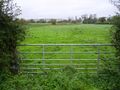
I thought it was in this field, but I may have been wrong.
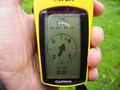
I couldn't get closer than 117m.
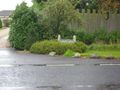
Manor Farm, on the other side of the road.


