Difference between revisions of "2010-10-08 56 13"
imported>Llavids m |
imported>FippeBot m (Location) |
||
| (2 intermediate revisions by 2 users not shown) | |||
| Line 13: | Line 13: | ||
== Plans == | == Plans == | ||
| − | The | + | The geohash was on the road of the most southern part of graticule 56 13 which made it easily accessible from our home. |
== Expedition == | == Expedition == | ||
| − | Drove to the | + | Drove to the geohash and passed it with my car. Parked and went back to document the GPS-readings and take some photos. I could not park there travelling north, since the street view from any coming cars was blocked. I had to go back and get the car and park it on the side travelling south, there it was easily spotted by passing vehicles. Took some photos of me and my car. Checked the area and found some litter just close to the geohash. Perfect for a geohash geotrash achievement and picked it all up, well documented in the photos. Since I was alone I could not take any photos when driving or picking litter. The photo of me and my car was taken when the camera was put on the ground. |
| − | Checked the nearest geocache and it was just 234 meters off. Had to relocate the car before venturing into the woods for the geocache. On my way to the geocache I found the old abandoned house and took some documenting pictures, uploaded to share with the community. Really fascinating to see that they left everything, including the | + | Checked the nearest geocache and it was just 234 meters off. Had to relocate the car before venturing into the woods for the geocache. On my way to the geocache I found the old abandoned house and took some documenting pictures, uploaded to share with the community. Really fascinating to see that they left everything, including the licquor. On a map I later found out that the place may have had the name "Månstorp". I have not found anything else about this place. The geocache was easily spotted and logged, also with pictures. Then I returned and drove home again. What a great geohash visit! |
== Photos == | == Photos == | ||
<gallery perrow="3"> | <gallery perrow="3"> | ||
| − | Image:101008-9-Me-at-hashespot.JPG|Me at | + | Image:101008-9-Me-at-hashespot.JPG|Me at hash location |
Image:101008-1-Hashespot-reached.JPG|Äskeröd, Höör, Skåne, Sweden | Image:101008-1-Hashespot-reached.JPG|Äskeröd, Höör, Skåne, Sweden | ||
| − | Image:101008-2-Car-parked-right-after-passing-hashespot.JPG|Car parked on the right side just after passing the | + | Image:101008-2-Car-parked-right-after-passing-hashespot.JPG|Car parked on the right side just after passing the geohash location |
| − | Image:101008-3-Right-view.JPG|Right view from the | + | Image:101008-3-Right-view.JPG|Right view from the geohash (not standing in the street, of course) |
Image:101008-4-Straight-ahead.JPG|View looking straight ahead | Image:101008-4-Straight-ahead.JPG|View looking straight ahead | ||
Image:101008-5-Left-view.JPG|Left view | Image:101008-5-Left-view.JPG|Left view | ||
| Line 32: | Line 32: | ||
Image:101008-7-Behind.JPG|Behind me | Image:101008-7-Behind.JPG|Behind me | ||
Image:101008-8-More-right.JPG|Even more right view | Image:101008-8-More-right.JPG|Even more right view | ||
| − | Image:101008-10-Road-ahead-south-is-hashespot.JPG|The road ahead (south) just before the bend is the | + | Image:101008-10-Road-ahead-south-is-hashespot.JPG|The road ahead (south) just before the bend is the geohash location |
| − | Image:101008-11-Me-and-my-car-at-hashespot.JPG|Me and my car at the | + | Image:101008-11-Me-and-my-car-at-hashespot.JPG|Me and my car at the geohash |
| − | Image:101008-12-Litter-1-m-off-hashespot.JPG|Litter found at the | + | Image:101008-12-Litter-1-m-off-hashespot.JPG|Litter found at the geohash |
Image:101008-13-Litter-found-and-removed-from-hashespot.JPG|Litter removed and put into my trunk | Image:101008-13-Litter-found-and-removed-from-hashespot.JPG|Litter removed and put into my trunk | ||
Image:101008-14-Closest-geocache.JPG|Closest geocashe, 234 meters off | Image:101008-14-Closest-geocache.JPG|Closest geocashe, 234 meters off | ||
| Line 53: | Line 53: | ||
== Achievements == | == Achievements == | ||
{{#vardefine:ribbonwidth|800px}} | {{#vardefine:ribbonwidth|800px}} | ||
| + | |||
| + | {{Land geohash | latitude = 56 | longitude = 13 | date = 2010-10-08 | name = [[User:Llavids|Llavids]] }} | ||
| + | |||
{{Minesweeper geohash | {{Minesweeper geohash | ||
| graticule = Malmö, Sweden | | graticule = Malmö, Sweden | ||
| Line 87: | Line 90: | ||
[[Category:Meetup on 2010-10-08]] | [[Category:Meetup on 2010-10-08]] | ||
[[Category:Sweden]] | [[Category:Sweden]] | ||
| + | {{location|SE|M}} | ||
Latest revision as of 04:06, 9 August 2019
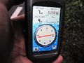
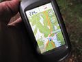
| Fri 8 Oct 2010 in 56,13: 56.0137673, 13.5497248 geohashing.info google osm bing/os kml crox |
Location
On the road close to Äskeröd, northwest of Höör, Skåne, Sweden.
Participants
Plans
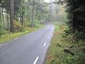
The geohash was on the road of the most southern part of graticule 56 13 which made it easily accessible from our home.
Expedition
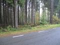
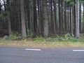
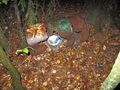
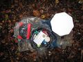
Drove to the geohash and passed it with my car. Parked and went back to document the GPS-readings and take some photos. I could not park there travelling north, since the street view from any coming cars was blocked. I had to go back and get the car and park it on the side travelling south, there it was easily spotted by passing vehicles. Took some photos of me and my car. Checked the area and found some litter just close to the geohash. Perfect for a geohash geotrash achievement and picked it all up, well documented in the photos. Since I was alone I could not take any photos when driving or picking litter. The photo of me and my car was taken when the camera was put on the ground.
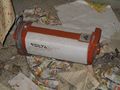
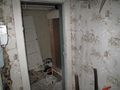
Checked the nearest geocache and it was just 234 meters off. Had to relocate the car before venturing into the woods for the geocache. On my way to the geocache I found the old abandoned house and took some documenting pictures, uploaded to share with the community. Really fascinating to see that they left everything, including the licquor. On a map I later found out that the place may have had the name "Månstorp". I have not found anything else about this place. The geocache was easily spotted and logged, also with pictures. Then I returned and drove home again. What a great geohash visit!
Photos

Me at hash location
Äskeröd, Höör, Skåne, Sweden
Car parked on the right side just after passing the geohash location
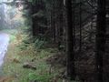
Right view from the geohash (not standing in the street, of course)
View looking straight ahead
Left view
Even more left view
Behind me
Even more right view
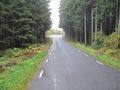
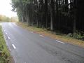
The road ahead (south) just before the bend is the geohash location
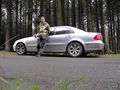
Me and my car at the geohash
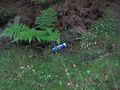
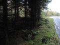
Litter found at the geohash
Litter removed and put into my trunk
Closest geocashe, 234 meters off
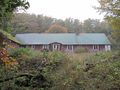
The abandoned house
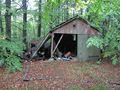
Old Volvo and garage in the forest
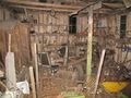
Inside the garage
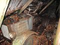
The Volvo was rebuilt into a tractor some time ago
Geocache hide
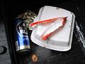
Geocache contents
Nobody vacuumed before leaving the house
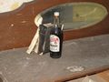
Left the licqour and bible
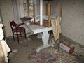
Old kitchen table
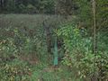
Old well
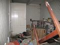
More rooms to clean
Nice wallpaper in the entryway


Achievements
Llavids earned the Land geohash achievement
|
Llavids achieved level 2 of the Minesweeper Geohash achievement
|
Llavids earned the Hash collision honorable mention
|
