Difference between revisions of "2010-10-08 61 24"
imported>PekkaR (→Achievements) |
imported>Benjw (clean up template; add Finnish cat) |
||
| Line 1: | Line 1: | ||
| − | |||
| − | |||
| − | |||
| − | |||
| − | |||
| − | |||
| − | |||
| − | |||
| − | |||
{{meetup graticule | {{meetup graticule | ||
| lat=61 | | lat=61 | ||
| Line 14: | Line 5: | ||
}} | }} | ||
| − | |||
__NOTOC__ | __NOTOC__ | ||
== Location == | == Location == | ||
| − | |||
On the highway 10 in Hämeenlinna. Highway 10 goes from Turku to Tuulos in Hämeenlinna. [http://kansalaisen.karttapaikka.fi/linkki?scale=8000&text=hash+20101008&srs=EPSG%3A3067&y=6766799&x=367550&lang=fi[Karttapaikka map]]. | On the highway 10 in Hämeenlinna. Highway 10 goes from Turku to Tuulos in Hämeenlinna. [http://kansalaisen.karttapaikka.fi/linkki?scale=8000&text=hash+20101008&srs=EPSG%3A3067&y=6766799&x=367550&lang=fi[Karttapaikka map]]. | ||
| Line 24: | Line 13: | ||
== Participants == | == Participants == | ||
| − | |||
* [[User:PekkaR|PekkaR]] | * [[User:PekkaR|PekkaR]] | ||
== Plans == | == Plans == | ||
| − | |||
Geohash was in Hämeenlinna yesterday and again today! I had to drive to Siiri and go to the hashpoint. | Geohash was in Hämeenlinna yesterday and again today! I had to drive to Siiri and go to the hashpoint. | ||
| Line 35: | Line 22: | ||
== Expedition == | == Expedition == | ||
| − | |||
I drived first through the geohash at the maximum legal speed 60 km/h. OK, maybe the speed was a little bit faster. I searched a geocache from Velssinmäki and then returned to Siiri. Siiri is also a woman's first name. It was about 4:30 pm when I reached the place. The traffic was heavy - people going home from work and also travelling for weekend. The hashpoint was on the highway 10 at the crossroads of Silmuntie. | I drived first through the geohash at the maximum legal speed 60 km/h. OK, maybe the speed was a little bit faster. I searched a geocache from Velssinmäki and then returned to Siiri. Siiri is also a woman's first name. It was about 4:30 pm when I reached the place. The traffic was heavy - people going home from work and also travelling for weekend. The hashpoint was on the highway 10 at the crossroads of Silmuntie. | ||
| Line 46: | Line 32: | ||
== Tracklog == | == Tracklog == | ||
| − | |||
<gallery perrow="4"> | <gallery perrow="4"> | ||
Image:2010-10-08_61-24_reitti.gif | Tracklog | Image:2010-10-08_61-24_reitti.gif | Tracklog | ||
| Line 52: | Line 37: | ||
== Photos == | == Photos == | ||
| − | |||
| − | |||
| − | |||
<gallery perrow="5"> | <gallery perrow="5"> | ||
Image:2010-10-08_61-24_gps.jpg | GPSr near hashpoint | Image:2010-10-08_61-24_gps.jpg | GPSr near hashpoint | ||
| Line 67: | Line 49: | ||
== Achievements == | == Achievements == | ||
{{#vardefine:ribbonwidth|800px}} | {{#vardefine:ribbonwidth|800px}} | ||
| − | |||
{{Speed racer | latitude = 61 | longitude = 24 | date = 2010-10-08 | name = PekkaR | image = PekkaR_300x500.jpg }} | {{Speed racer | latitude = 61 | longitude = 24 | date = 2010-10-08 | name = PekkaR | image = PekkaR_300x500.jpg }} | ||
{{consecutive geohash | count = 2 | latitude = 61 | longitude = 24 | date = 2010-10-07 | name = PekkaR }} | {{consecutive geohash | count = 2 | latitude = 61 | longitude = 24 | date = 2010-10-07 | name = PekkaR }} | ||
| − | |||
| − | |||
| − | |||
| − | |||
| − | |||
| − | |||
| − | |||
| − | |||
| − | |||
[[Category:Expeditions]] | [[Category:Expeditions]] | ||
| − | |||
| − | |||
[[Category:Expeditions with photos]] | [[Category:Expeditions with photos]] | ||
| − | |||
| − | |||
| − | |||
[[Category:Coordinates reached]] | [[Category:Coordinates reached]] | ||
| − | + | [[Category:Pages in Finnish]] | |
| − | |||
| − | |||
| − | |||
| − | |||
| − | |||
| − | |||
| − | [[Category: | ||
| − | |||
Revision as of 07:35, 12 October 2010
| Fri 8 Oct 2010 in 61,24: 61.0137673, 24.5497248 geohashing.info google osm bing/os kml crox |
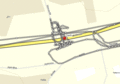
Location
On the highway 10 in Hämeenlinna. Highway 10 goes from Turku to Tuulos in Hämeenlinna. [Karttapaikka map].
Hässipiste sijaitsee valtatie 10:llä Hämeenlinnan Siirissä. [Karttapaikka].
Participants
Plans
Geohash was in Hämeenlinna yesterday and again today! I had to drive to Siiri and go to the hashpoint.
Hässipiste toisena päivänä peräkkäin Hämeenlinnassa ja vielä samalla suunnalla, kaupungin itäpuolella. Oli pakko lähteä ajelemaan Siiriä kohti.
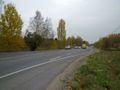
Expedition
I drived first through the geohash at the maximum legal speed 60 km/h. OK, maybe the speed was a little bit faster. I searched a geocache from Velssinmäki and then returned to Siiri. Siiri is also a woman's first name. It was about 4:30 pm when I reached the place. The traffic was heavy - people going home from work and also travelling for weekend. The hashpoint was on the highway 10 at the crossroads of Silmuntie.
It was too dangerous to stay on the road and get GPS to show distance of 0 metres but I walked several times over the hashpoint.
Ajoin aluksi hässipisteen yli suurimmalla sallitulla nopeudella 60 km tunnissa. No joo, saattoi olla mittarissa vähän ylinopeutta. Hain geokätkön Velssinmäestä ja palasin Siiriin. Mukava paikannimi, onkohan siellä asunut joskus joku Siiri? Kello oli noin 16:30. Liikenne oli vilkasta - Hämeenlinnassakin on neljän ruuhka, ja varmaan oli aika paljon viikonloppuliikennettäkin. Hässipiste oli siis valtatie 10:llä Silmuntien risteyksen kohdalla.
En voinut seisoa tiellä ja odottaa gepsin asettumista nollalukemaan mutta kävelin useaan kertaan tien yli hässipisteen päältä.
Tracklog
Tracklog

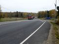
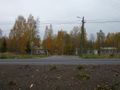
Photos
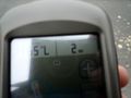
GPSr near hashpoint
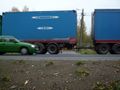
Highway 10
Road from Lahti
Road from Hämeenlinna
View to Silmuntie
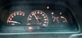
Speed 60 km/h
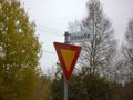
Silmuntie


Achievements


PekkaR earned the Consecutive geohash achievement
|