Difference between revisions of "2010-10-08 65 25"
From Geohashing
imported>Ossisanni (Meeting added) |
imported>Ossisanni m |
||
| Line 23: | Line 23: | ||
File:2010-10-08_65_25_SangintieToSE.JPG|Same road to other direction. The hash point is just under a car. | File:2010-10-08_65_25_SangintieToSE.JPG|Same road to other direction. The hash point is just under a car. | ||
File:2010-10-08_65_25_PictureFromBridge.JPG|A little river run under the road around 70m away from the hash point | File:2010-10-08_65_25_PictureFromBridge.JPG|A little river run under the road around 70m away from the hash point | ||
| − | File:2010-10-08_65_25_HashPoint_GPS_and_Speedmeter.JPG|GPS shows hash point and speed | + | File:2010-10-08_65_25_HashPoint_GPS_and_Speedmeter.JPG|GPS shows hash point and speed limit is 40km/h |
</gallery> | </gallery> | ||
Revision as of 18:28, 8 October 2010
| Fri 8 Oct 2010 in Oulu, Finland: 65.0137673, 25.5497248 geohashing.info google osm bing/os kml crox |
Location
Geohash point is in city of Oulu, Saarela neighborhood.
Participant
Plans
Plan is to go to hash place after office hours around 16:00 EET
Expedition
I found parking place around 100m away from geohas point. By walking towards the point it came obviously, that hash point was middle of the road. I tried to take photos in exact point, but it was mission impossible due heavy traffic on the road. Best option was to drive through the geohash.
Photos
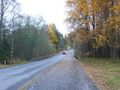
The road goes to North-West.
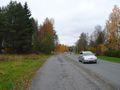
Same road to other direction. The hash point is just under a car.
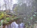
A little river run under the road around 70m away from the hash point
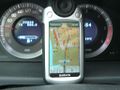
GPS shows hash point and speed limit is 40km/h


Achievements

Ossisanni earned the Speed racer achievement
by passing through the (65, 25) geohash on 2010-10-08 at the maximum legal speed.