2010-10-09 -19 146
From Geohashing
Revision as of 09:17, 9 October 2010 by imported>Mattyk (→Photos)
| Sat 9 Oct 2010 in -19,146: -19.6427434, 146.8359639 geohashing.info google osm bing/os kml crox |
Location
On side of Flinders Highway just past Woodstock.
Participants
Plans
JimmyNZ's Plans
Will try to get some tiem off work again and cruise out. Fingers crossed, should be an easy one.
mattyk's Plans
If I can find time, I will whip out with my whole family some time today. Probably no awesome engraved wooden markers this time.
Expedition
mattyk's Expedition
After a day of errands and chores, we headed out from Castletown at 16:30. At about 17:00, just past the point, we crossed the highway and drove up a little railway access track, then followed the precarious railway service track to a spot 15m from the point. We hoofed it the rest of the way, snapped some photos, and came home.
Tracklog
Photos
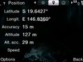
Screenshot of MattyK's GPS phone

MattyK's family at the point

