Difference between revisions of "2010-10-24 43 -79"
imported>Splitdipless (Created page with '{{subst:Expedition |lat = 43 |lon = -79 |date = 2010-10-24 }}') |
m (More specific location) |
||
| (5 intermediate revisions by 4 users not shown) | |||
| Line 1: | Line 1: | ||
| − | |||
| − | |||
| − | |||
| − | |||
| − | |||
| − | |||
| − | |||
| − | |||
| − | |||
| − | |||
{{meetup graticule | {{meetup graticule | ||
| lat=43 | | lat=43 | ||
| Line 18: | Line 8: | ||
__NOTOC__ | __NOTOC__ | ||
== Location == | == Location == | ||
| − | + | The geohast point was located in south Ajax along a park path near the fenceline of someone's backyard. | |
== Participants == | == Participants == | ||
| − | + | *[[User:Splitdipless|Splitdipless]] | |
== Plans == | == Plans == | ||
| − | + | === [[User:Splitdipless|Splitdipless]] === | |
| + | |||
| + | Oddly enough, I'm working today, and work is close. The geohash looks like it could either be in someone's backyard, or near the fence in a park. Hopefully the latter. | ||
== Expedition == | == Expedition == | ||
| − | + | === [[User:Splitdipless|Splitdipless]] === | |
| − | + | So, I took a few moments to print off a page concerning geohashing, just in case I had to go and ask to go in someone's backyard. I also wanted to see if there where any geocaches nearby (being in a park), but sadly, my company's browser is no longer supported by groundspeak. (I can't complain too much, as at least I have some Internet there.) | |
| − | + | ||
| + | I hopped in 'Em,' my car, and made it to the park in short time. I made a note of the temperature: 9°C. I have a cold, the air is cold, it's near the lake and I'm wearing a spring jacket and a golf shirt instead of something reasonable, like a sweater and a fall coat. I become resolved to get the point as quick as I can. | ||
| + | |||
| + | As I'm walking the path with my GPS out, I get a strange look by an old lady taking a stroll. I'm practically invisible to the dog walkers. I get to a point in the path where the point is 10m off to the side. I look over at the fence 5m away and I heave a sigh. As I get halfway to the fence, I look down and notice the GPS says 5m all of a sudden. I have hope that I'll at least get within the accuracy of the GPS. Just as I get to the fence, the GPS jumps from 5m to 2m within an accuracy of 3m! I take my photos then look over the ground. The last 3m was little over 1m away. | ||
| + | |||
| + | That was enough excitement for one day. When I got home, I took a nap. My cold wouldn't let me stay up long enough to post my adventure. | ||
== Photos == | == Photos == | ||
| − | |||
| − | |||
| − | |||
<gallery perrow="5"> | <gallery perrow="5"> | ||
| + | Image:2010-10-24 43 -79 0.7 A.jpg | Shortest 3m EVAR! | ||
| + | Image:2010-10-24 43 -79 0.7 B.jpg | A lovely path, on a cool day. | ||
| + | Image:2010-10-24 43 -79 0.7 C.jpg | Stupid grin. | ||
</gallery> | </gallery> | ||
== Achievements == | == Achievements == | ||
{{#vardefine:ribbonwidth|800px}} | {{#vardefine:ribbonwidth|800px}} | ||
| − | + | === [[User:Splitdipless|Splitdipless]] === | |
| + | Nothing new. | ||
| − | |||
| − | |||
| − | |||
| − | |||
| − | |||
| − | |||
| − | |||
| − | |||
| − | |||
| − | |||
[[Category:Expeditions]] | [[Category:Expeditions]] | ||
| − | |||
[[Category:Expeditions with photos]] | [[Category:Expeditions with photos]] | ||
| − | |||
| − | |||
| − | |||
| − | |||
| − | |||
[[Category:Coordinates reached]] | [[Category:Coordinates reached]] | ||
| − | + | {{location|CA|ON|DR}} | |
| − | |||
| − | |||
| − | |||
| − | |||
| − | |||
| − | |||
| − | |||
| − | |||
| − | |||
Latest revision as of 23:35, 9 August 2020
| Sun 24 Oct 2010 in 43,-79: 43.8226304, -79.0183318 geohashing.info google osm bing/os kml crox |
Location
The geohast point was located in south Ajax along a park path near the fenceline of someone's backyard.
Participants
Plans
Splitdipless
Oddly enough, I'm working today, and work is close. The geohash looks like it could either be in someone's backyard, or near the fence in a park. Hopefully the latter.
Expedition
Splitdipless
So, I took a few moments to print off a page concerning geohashing, just in case I had to go and ask to go in someone's backyard. I also wanted to see if there where any geocaches nearby (being in a park), but sadly, my company's browser is no longer supported by groundspeak. (I can't complain too much, as at least I have some Internet there.)
I hopped in 'Em,' my car, and made it to the park in short time. I made a note of the temperature: 9°C. I have a cold, the air is cold, it's near the lake and I'm wearing a spring jacket and a golf shirt instead of something reasonable, like a sweater and a fall coat. I become resolved to get the point as quick as I can.
As I'm walking the path with my GPS out, I get a strange look by an old lady taking a stroll. I'm practically invisible to the dog walkers. I get to a point in the path where the point is 10m off to the side. I look over at the fence 5m away and I heave a sigh. As I get halfway to the fence, I look down and notice the GPS says 5m all of a sudden. I have hope that I'll at least get within the accuracy of the GPS. Just as I get to the fence, the GPS jumps from 5m to 2m within an accuracy of 3m! I take my photos then look over the ground. The last 3m was little over 1m away.
That was enough excitement for one day. When I got home, I took a nap. My cold wouldn't let me stay up long enough to post my adventure.
Photos
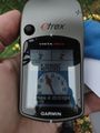
Shortest 3m EVAR!
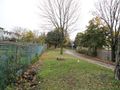
A lovely path, on a cool day.

Stupid grin.


Achievements
Splitdipless
Nothing new.