Difference between revisions of "2010-11-02 50 8"
imported>Mampfred (Created page with '{{subst:Expedition |lat = latitude of graticule |lon = longitude of graticule |date = date of expedition, in YYYY-MM-DD format }}') |
imported>FippeBot m (Location) |
||
| (7 intermediate revisions by one other user not shown) | |||
| Line 1: | Line 1: | ||
| − | |||
| − | |||
| − | |||
| − | |||
| − | |||
| − | |||
| − | |||
| − | |||
| − | |||
| − | |||
{{meetup graticule | {{meetup graticule | ||
| − | | lat= | + | | lat=50 |
| − | | lon= | + | | lon=8 |
| − | | date= | + | | date=2010-11-02 |
}} | }} | ||
| − | |||
| − | |||
== Location == | == Location == | ||
| − | + | Right behind the end of the tracks of the U6 line in Frankfurt am Main 10 meters into a field. | |
== Participants == | == Participants == | ||
| − | + | *[[User:Mampfred|Mampfred]] | |
== Plans == | == Plans == | ||
| − | + | Get there in the morning before atending a meeting in Frankfurt and be back at the main station in time. | |
== Expedition == | == Expedition == | ||
| − | + | Pretty straight forward, I left Niedernhausen at 08:03 in the morning with the S2 line and with a stopover at Hauptwache Frankfurt I changed to the U6 and rode it all the way to the end. | |
| + | |||
| + | A short walk later I reached the end of the tracks and found a little path around it leading to the field that contained the hash. I carefully rounded the field and aproached the spot from the side that would be least intrusive. Conveniently there was a marker saying "enter field here" (see image below) so I decided to go for it as it was dry and I could reach the hash with a couple of big steps into the field. | ||
| + | |||
| + | Snapped a panorama-photo (which I later discovered needs to be explicitely saved to the memory card - which I didn't notice back then so it's lost - great user interface design guys, I'm explicitely NOT going to mention that I'm using a Samsung S8500 Wave first generation for my photos here as that wouldn't be very nice, m'kay?) and headed back to the Hauptbahnhof (changed at Bockenheimer Warte this time) where I was attacked by a giant dinosaur ... well, I attacked it with the camera really as it's a huge display at the main station in Frankfurt (and yes, by then I was in a hurry so it's a bit blurred - this time it was my fault, not the mobile phone's ;). But then again - that's probably the closest someone in germany (europe even?) ever got to a [[Raptor geohash]], ey? ;) | ||
| + | |||
| + | I'm writing this from the lounge in the main station (lucky Bahn Comfort customer) so I'll add pictures and the tracklog later (forgot to bring the right cables at least for the GPS). | ||
== Tracklog == | == Tracklog == | ||
| − | + | See [http://www.everytrail.com/view_trip.php?trip_id=871587 here]. | |
== Photos == | == Photos == | ||
| − | |||
| − | |||
| − | |||
<gallery perrow="5"> | <gallery perrow="5"> | ||
| + | Image:2010-11-02_50_8_end_of_trail_1.jpg | Next to the end of the tracks ... | ||
| + | Image:2010-11-02_50_8_end_of_trail_2.jpg | ... on the other side of the end of the tracks in fact ... | ||
| + | Image:2010-11-02_50_8_edge_of_field.jpg | ... edging around the field until ... | ||
| + | Image:2010-11-02_50_8_x.jpg | ... X marks the spot ... to enter the field. | ||
| + | Image:2010-11-02_50_8_coordinates.jpg | Coordinates ... | ||
| + | Image:2010-11-02_50_8_reached.jpg | ... reached | ||
| + | Image:2010-11-02_50_8_no_grin.jpg | [[User:Mampfred|Mampfred]] - forgot the stupid grin(tm) though ... and to shave | ||
| + | Image:2010-11-02_50_8_dinosaur.jpg | Raptor Hash ... sort of | ||
</gallery> | </gallery> | ||
== Achievements == | == Achievements == | ||
{{#vardefine:ribbonwidth|800px}} | {{#vardefine:ribbonwidth|800px}} | ||
| − | + | {{public transport geohash | |
| − | + | | latitude = 50 | |
| − | + | | longitude = 8 | |
| − | + | | date = 2010-11-02 | |
| − | + | | name = Mampfred | |
| − | + | }} | |
| − | + | {{Land geohash | |
| − | + | | latitude = 50 | |
| − | + | | longitude = 8 | |
| − | + | | date = 2010-11-02 | |
| − | -- | + | | name = Mampfred |
| − | + | }} | |
| − | + | {{Consecutive_geohash | |
| + | | latitude = 50 | ||
| + | | longitude = 8 | ||
| + | | count = 2 | ||
| + | | date = 2010-11-01 | ||
| + | | name = Mampfred | ||
| + | }} | ||
[[Category:Expeditions]] | [[Category:Expeditions]] | ||
| − | |||
[[Category:Expeditions with photos]] | [[Category:Expeditions with photos]] | ||
| − | |||
| − | |||
| − | |||
| − | |||
| − | |||
[[Category:Coordinates reached]] | [[Category:Coordinates reached]] | ||
| − | + | {{location|DE|HE|F}} | |
| − | |||
| − | |||
| − | |||
| − | |||
| − | |||
| − | |||
| − | |||
| − | |||
| − | |||
Latest revision as of 04:27, 9 August 2019
| Tue 2 Nov 2010 in 50,8: 50.1482893, 8.6065891 geohashing.info google osm bing/os kml crox |
Location
Right behind the end of the tracks of the U6 line in Frankfurt am Main 10 meters into a field.
Participants
Plans
Get there in the morning before atending a meeting in Frankfurt and be back at the main station in time.
Expedition
Pretty straight forward, I left Niedernhausen at 08:03 in the morning with the S2 line and with a stopover at Hauptwache Frankfurt I changed to the U6 and rode it all the way to the end.
A short walk later I reached the end of the tracks and found a little path around it leading to the field that contained the hash. I carefully rounded the field and aproached the spot from the side that would be least intrusive. Conveniently there was a marker saying "enter field here" (see image below) so I decided to go for it as it was dry and I could reach the hash with a couple of big steps into the field.
Snapped a panorama-photo (which I later discovered needs to be explicitely saved to the memory card - which I didn't notice back then so it's lost - great user interface design guys, I'm explicitely NOT going to mention that I'm using a Samsung S8500 Wave first generation for my photos here as that wouldn't be very nice, m'kay?) and headed back to the Hauptbahnhof (changed at Bockenheimer Warte this time) where I was attacked by a giant dinosaur ... well, I attacked it with the camera really as it's a huge display at the main station in Frankfurt (and yes, by then I was in a hurry so it's a bit blurred - this time it was my fault, not the mobile phone's ;). But then again - that's probably the closest someone in germany (europe even?) ever got to a Raptor geohash, ey? ;)
I'm writing this from the lounge in the main station (lucky Bahn Comfort customer) so I'll add pictures and the tracklog later (forgot to bring the right cables at least for the GPS).
Tracklog
See here.
Photos
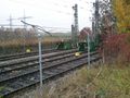
Next to the end of the tracks ...
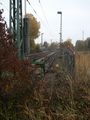
... on the other side of the end of the tracks in fact ...
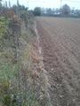
... edging around the field until ...
... X marks the spot ... to enter the field.
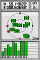
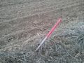
Coordinates ...
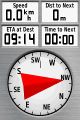
... reached

Mampfred - forgot the stupid grin(tm) though ... and to shave
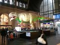
Raptor Hash ... sort of


Achievements
Mampfred earned the Public transport geohash achievement
|
Mampfred earned the Land geohash achievement
|
Mampfred earned the Consecutive geohash achievement
|