Difference between revisions of "2010-11-26 46 -123"
imported>Aperfectring ([live] Thwarted by a 100% grade which was wet, muddy, and covered in leaves.) |
imported>FippeBot m (Location) |
||
| (4 intermediate revisions by 2 users not shown) | |||
| Line 1: | Line 1: | ||
| − | |||
<!-- If you did not specify these parameters in the template, please substitute appropriate values for IMAGE, LAT, LON, and DATE (YYYY-MM-DD format) | <!-- If you did not specify these parameters in the template, please substitute appropriate values for IMAGE, LAT, LON, and DATE (YYYY-MM-DD format) | ||
| Line 15: | Line 14: | ||
}} | }} | ||
| − | |||
__NOTOC__ | __NOTOC__ | ||
== Location == | == Location == | ||
| Line 21: | Line 19: | ||
== Participants == | == Participants == | ||
| − | * [[User:Jiml| | + | * [[User:Jiml|Jim]] |
* [[User:Aperfectring|APR]] | * [[User:Aperfectring|APR]] | ||
| Line 28: | Line 26: | ||
== Expedition == | == Expedition == | ||
| − | + | After a fun adventure reloading crates into the car, Jim arrived at APR's place, and we started out for | |
| + | the hashpoint. We stopped partway there to get lunch, and then started over the hill. | ||
| + | |||
| + | Cornelius Pass Road was uneventful, and then we got to Hwy 30, and headed North. Eventually, APR's navi-GPS | ||
| + | told us we needed to turn, so we did. The road kept getting smaller and smaller, and eventually the pavement | ||
| + | gave way to gravel. | ||
| + | |||
| + | And a gate appeared. But we were only 300 feet from the hashpoint. Except for the canal in the way. | ||
| + | But we expected, it, and walked a quarter mile up to a bridge that got us to the other side. Then we | ||
| + | walked a quarter mile through the woods. There was a path initially, but it eventually disappeared | ||
| + | into a lot of mud. | ||
| + | |||
| + | Finally we came around a turn, and found ourselves with GPS's that said "Go 70 feet that way". But | ||
| + | "that way" was up a 45 degree slope. Jim made a 3 foot attempt and found it just as slick and slippery as we | ||
| + | had suspected. | ||
| + | |||
| + | Mother Nature won. We went back to the car, let the dogs out to stretch and headed back to Hillsboro. | ||
| + | |||
*Thwarted by a 100% grade which was wet, muddy, and covered in leaves. -- [[User:Aperfectring|aperfectring]] 23:15, 26 November 2010 (UTC) | *Thwarted by a 100% grade which was wet, muddy, and covered in leaves. -- [[User:Aperfectring|aperfectring]] 23:15, 26 November 2010 (UTC) | ||
| − | + | ||
| − | |||
== Photos == | == Photos == | ||
| − | + | ||
| − | + | <gallery perrow="4"> | |
| − | |||
| − | <gallery perrow=" | ||
Image:2010-11-26_46_-123_13-53-02-670.jpg | On the road, driving through the rain. [http://www.openstreetmap.org/?lat=45.7850&lon=-122.8730&zoom=16&layers=B000FTF @45.7850,-122.8730] | Image:2010-11-26_46_-123_13-53-02-670.jpg | On the road, driving through the rain. [http://www.openstreetmap.org/?lat=45.7850&lon=-122.8730&zoom=16&layers=B000FTF @45.7850,-122.8730] | ||
| + | File:2010-11-26_46_-123_apr01.jpg | The only bridge across the Columbia for at least 20 miles either way | ||
| + | File:2010-11-26_46_-123_apr02.jpg | An "upskirt" of said bridge | ||
| + | File:2010-11-26_46_-123_apr03.jpg | It looked promising while this path existed. It shortly ended in muddy/marshy ground. | ||
| + | File:2010-11-26_46_-123_apr04.jpg | The hashpoint is up there somewhere. We think its relatively near the large clump of trees. | ||
| + | File:2010-11-26_46_-123_apr07.jpg | If you look closely, you can see a little blue SUV in this pic. It is only about 400ft away from the hashpoint. | ||
| + | File:2010-11-26_46_-123_apr08.jpg | Proof! | ||
| + | File:2010-11-26_46_-123_apr10.jpg | Jim, saddened by our unexpected thwarting. | ||
| + | File:2010-11-26_46_-123_apr11.jpg | A pic of some mossy trees near the hashpoint. | ||
| + | File:2010-11-26_46_-123_apr12.jpg | The aforementioned marshy ground. | ||
| + | File:2010-11-26_46_-123_apr13.jpg | We were under these basically the whole time we were hashing. We'll probably both end up with cancer or something. | ||
</gallery> | </gallery> | ||
== Achievements == | == Achievements == | ||
{{#vardefine:ribbonwidth|800px}} | {{#vardefine:ribbonwidth|800px}} | ||
| − | |||
| + | {{Cliffs of Despair | ||
| + | | name = [[User:Jiml|Jim]] and [[User:Aperfectring|APR]] | ||
| + | | latitude = 46 | ||
| + | | longitude = -123 | ||
| + | | date = 2010-11-26 | ||
| + | }} | ||
| − | |||
| − | |||
| − | |||
| − | |||
| − | |||
| − | |||
| − | |||
| − | |||
| − | |||
[[Category:Expeditions]] | [[Category:Expeditions]] | ||
| − | |||
[[Category:Expeditions with photos]] | [[Category:Expeditions with photos]] | ||
| − | + | [[Category:Coordinates not reached]] | |
| − | |||
| − | |||
| − | |||
| − | |||
| − | [[Category:Coordinates reached]] | ||
| − | |||
| − | + | [[Category:Not reached - Mother Nature]] | |
| − | + | {{location|US|OR|CL}} | |
| − | |||
| − | [[Category:Not reached - Mother Nature]] | ||
| − | |||
| − | |||
| − | |||
| − | |||
Latest revision as of 04:45, 9 August 2019
| Fri 26 Nov 2010 in 46,-123: 46.1211388, -123.0334835 geohashing.info google osm bing/os kml crox |
Location
Looks to be under some high-tension power lines near the Columbia River, up near Rainier, OR.
Participants
Plans
Jiml will stop by APR's place, with two dogs, at about noon. They will grab a quick lunch, and then head off to the hashpoint, for expedition fun in the 45F (7C) rainy weather that is a typical Oregon November day.
Expedition
After a fun adventure reloading crates into the car, Jim arrived at APR's place, and we started out for the hashpoint. We stopped partway there to get lunch, and then started over the hill.
Cornelius Pass Road was uneventful, and then we got to Hwy 30, and headed North. Eventually, APR's navi-GPS told us we needed to turn, so we did. The road kept getting smaller and smaller, and eventually the pavement gave way to gravel.
And a gate appeared. But we were only 300 feet from the hashpoint. Except for the canal in the way. But we expected, it, and walked a quarter mile up to a bridge that got us to the other side. Then we walked a quarter mile through the woods. There was a path initially, but it eventually disappeared into a lot of mud.
Finally we came around a turn, and found ourselves with GPS's that said "Go 70 feet that way". But "that way" was up a 45 degree slope. Jim made a 3 foot attempt and found it just as slick and slippery as we had suspected.
Mother Nature won. We went back to the car, let the dogs out to stretch and headed back to Hillsboro.
- Thwarted by a 100% grade which was wet, muddy, and covered in leaves. -- aperfectring 23:15, 26 November 2010 (UTC)
Photos
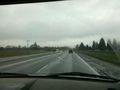
On the road, driving through the rain. @45.7850,-122.8730
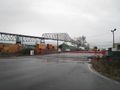
The only bridge across the Columbia for at least 20 miles either way
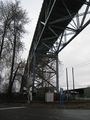
An "upskirt" of said bridge
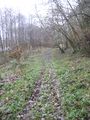
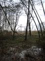
It looked promising while this path existed. It shortly ended in muddy/marshy ground.
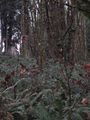
The hashpoint is up there somewhere. We think its relatively near the large clump of trees.
If you look closely, you can see a little blue SUV in this pic. It is only about 400ft away from the hashpoint.
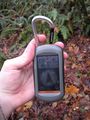
Proof!
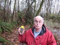
Jim, saddened by our unexpected thwarting.
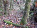
A pic of some mossy trees near the hashpoint.
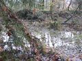
The aforementioned marshy ground.
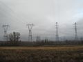
We were under these basically the whole time we were hashing. We'll probably both end up with cancer or something.


Achievements
Jim and APR earned the Cliffs of Despair consolation prize
|