Difference between revisions of "2010-11-30 49 -122"
imported>Wade (I did it! Sort of.) |
m (More specific location) |
||
| (6 intermediate revisions by 3 users not shown) | |||
| Line 1: | Line 1: | ||
| − | |||
| − | |||
| − | |||
| − | |||
| − | |||
| − | |||
| − | |||
| − | |||
| − | |||
{{meetup graticule | {{meetup graticule | ||
| lat=49 | | lat=49 | ||
| Line 16: | Line 7: | ||
__NOTOC__ | __NOTOC__ | ||
| + | |||
== Location == | == Location == | ||
On highway 1, near New Westminster. | On highway 1, near New Westminster. | ||
| Line 21: | Line 13: | ||
== Participants == | == Participants == | ||
* [[User:Wade|Wade]] | * [[User:Wade|Wade]] | ||
| + | * [[user:thepiguy]] | ||
| + | * [[user:MylSh|MylSh]] | ||
== Plans == | == Plans == | ||
| Line 31: | Line 25: | ||
== Expedition == | == Expedition == | ||
| + | ===Wade=== | ||
I once again completely missed the point of geohashing. As you know, geohashing is all about meeting strangers to have fun, getting outside, getting a bit of exercise, and sometimes a challenging adventure. | I once again completely missed the point of geohashing. As you know, geohashing is all about meeting strangers to have fun, getting outside, getting a bit of exercise, and sometimes a challenging adventure. | ||
| − | So, I got on my bike, burned gasoline for about half an hour in the pouring rain though tedious rush-hour traffic. As I approached the hash point I noticed the traffic was really heavy, the visibility was poor, and the shoulder was really narrow because of construction. It wasn't safe to stop, but I glance down at the GPS just at the moment to see "0" in the "distance to destination" box. I kept going, pushed the "go home" button on the GPS, and followed the instructions home. I successfully reached the point without: | + | So, I got on my bike, burned gasoline for about half an hour in the pouring rain though tedious rush-hour traffic. As I approached the hash point I noticed the traffic was really heavy, the visibility was poor, and the shoulder was really narrow because of construction. It wasn't safe to stop, but I glance down at the GPS just at the moment to see "0" in the "distance to destination" box. I kept going, pushed the "go home" button on the GPS, and followed the instructions home. |
| + | |||
| + | I successfully reached the point without: | ||
* getting exercise | * getting exercise | ||
* being somewhere I've never been before | * being somewhere I've never been before | ||
| Line 41: | Line 38: | ||
* stopping | * stopping | ||
* getting photographic proof of reaching the point | * getting photographic proof of reaching the point | ||
| + | * getting a screenshot of my GPS at the "0" point | ||
* profiting | * profiting | ||
The track log, if I manage to upload it, may show that I was there. Or it may not. | The track log, if I manage to upload it, may show that I was there. Or it may not. | ||
| + | |||
| + | ===user:thepiguy and MylSh=== | ||
| + | I guess we did pretty much the same thing as Wade. However we did manage to: | ||
| + | |||
| + | * play games with people (if you count silly licence plate games) | ||
| + | * meet new friends (if you count all the friendly people that let me merge back and forth through traffic) | ||
| + | * interact with other humans (see "meet new friends" above) | ||
| + | * stop (if you count terrible rush hour traffic on the highway) | ||
| + | * get photographic proof of reaching the point (if you count MylSh's valiant attempts using my broken camera) | ||
| + | * profit (if you count life experience. Ok... that one's a stretch) | ||
== Photos == | == Photos == | ||
| − | < | + | <gallery> |
| − | Image:2010- | + | Image:2010-11-30_49_-122_traffic1.JPG|Passing by [http://www.mec.ca MEC] on the way out! |
| − | --> | + | Image:2010-11-30_49_-122_traffic2.JPG|Traffic. |
| − | < | + | Image:2010-11-30_49_-122_traffic3.JPG|More traffic. |
| − | + | Image:2010-11-30_49_-122_pi.JPG|thepiguy <i>loves</i> driving through traffic. | |
| + | Image:2010-11-30_49_-122_gps.JPG|There was a lot of fumbling and yelling, but we got decent proof. | ||
| + | Image:2010-11-30_49_-122.JPG|Geohashers!. | ||
| + | Image:2010-11-30 49 -122_Full_Tracklog.jpeg|Wade's Tracklog | ||
</gallery> | </gallery> | ||
[[Category:Expeditions]] | [[Category:Expeditions]] | ||
| − | |||
[[Category:Expeditions with photos]] | [[Category:Expeditions with photos]] | ||
| − | |||
[[Category:Coordinates reached]] | [[Category:Coordinates reached]] | ||
| + | {{location|CA|BC|MV}} | ||
Latest revision as of 23:37, 9 August 2020
| Tue 30 Nov 2010 in 49,-122: 49.2411806, -122.9606610 geohashing.info google osm bing/os kml crox |
Location
On highway 1, near New Westminster.
Participants
Plans
The plan is:
- go to work
- on the way home from work, drive to New Westminister
- ???
- profit!
Expedition
Wade
I once again completely missed the point of geohashing. As you know, geohashing is all about meeting strangers to have fun, getting outside, getting a bit of exercise, and sometimes a challenging adventure.
So, I got on my bike, burned gasoline for about half an hour in the pouring rain though tedious rush-hour traffic. As I approached the hash point I noticed the traffic was really heavy, the visibility was poor, and the shoulder was really narrow because of construction. It wasn't safe to stop, but I glance down at the GPS just at the moment to see "0" in the "distance to destination" box. I kept going, pushed the "go home" button on the GPS, and followed the instructions home.
I successfully reached the point without:
- getting exercise
- being somewhere I've never been before
- playing games with people
- meeting new friends
- interacting with any other humans
- stopping
- getting photographic proof of reaching the point
- getting a screenshot of my GPS at the "0" point
- profiting
The track log, if I manage to upload it, may show that I was there. Or it may not.
user:thepiguy and MylSh
I guess we did pretty much the same thing as Wade. However we did manage to:
- play games with people (if you count silly licence plate games)
- meet new friends (if you count all the friendly people that let me merge back and forth through traffic)
- interact with other humans (see "meet new friends" above)
- stop (if you count terrible rush hour traffic on the highway)
- get photographic proof of reaching the point (if you count MylSh's valiant attempts using my broken camera)
- profit (if you count life experience. Ok... that one's a stretch)
Photos
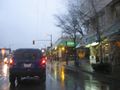
Passing by MEC on the way out!
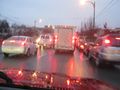
Traffic.
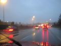
More traffic.
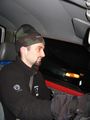
thepiguy loves driving through traffic.
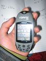
There was a lot of fumbling and yelling, but we got decent proof.
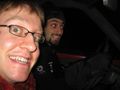
Geohashers!.
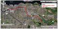
Wade's Tracklog


