Difference between revisions of "2010-12-08 55 13"
imported>Fasanen (Plans) |
imported>FippeBot m (Location) |
||
| (One intermediate revision by one other user not shown) | |||
| Line 1: | Line 1: | ||
| − | |||
| − | |||
| − | |||
| − | |||
| − | |||
| − | |||
| − | |||
| − | |||
| − | |||
{{meetup graticule | {{meetup graticule | ||
| lat=55 | | lat=55 | ||
| Line 14: | Line 5: | ||
}} | }} | ||
| − | |||
__NOTOC__ | __NOTOC__ | ||
== Location == | == Location == | ||
| Line 25: | Line 15: | ||
* Setup looks pretty much the same as for [[2010-12-06_55_13 | 2010-12-06]]. | * Setup looks pretty much the same as for [[2010-12-06_55_13 | 2010-12-06]]. | ||
* Bring skis. | * Bring skis. | ||
| − | * Maybe go there during daytime. Natural light adds to the perception of the place visited :-) | + | * <s>Maybe go there during daytime. Natural light adds to the perception of the place visited :-) </s> |
== Expedition == | == Expedition == | ||
| − | + | This expedition was almost a revival of my expedition [[2010-12-06_55_13 | 2010-12-06]]. The setting was the pretty much the same; a field normally inaccessible this time of year because of growing crops in a haze of rain coming down horizontally. However things are currently a bit different here when we have “been blessed” by intense snow fall during a week or so. As this graticule consists of much farmland, its nice to be able to go geohashing to locations normally not accessible and also do so by ski. | |
| − | + | My initial plans to go hashing in daylight never materialized. I left home about seven in the evening darkness and got to the Jordberga estate where I managed to park the car next to a big barn. It was about half a kilometer left to the hashpoint when I put the skis on. Light snow flurries were coming down and it was quite chilly in the wind but the snow crust was perfect for skiing. I quickly got to the hashpoint. The thermometer indicated an air temperture of -2° C but the wind-chill factor made it painful to operate the camera without gloves. | |
| − | + | ||
| + | After taking a few photographs, I packed my stuff and started skiing back. I was very surprised when I suddenly got to a road that I hadn’t crossed on my way to the hash. After a sanity check with the GPS, I realized that I was southbound instead of my intention of being bound for west. This was probably due to the fact that I had calibrated the GPS compass at the hashpoint by turning around twice. With few visible landmarks in the darkness, that was apparently enough to get my head confused about the point of compass. I corrected my course and got back to my old tracks where the snow was excellent. I was back home shortly after eight. | ||
== Photos == | == Photos == | ||
| − | < | + | <gallery perrow="3"> |
| − | Image: | + | Image:201012085513 01.JPG | Yet another frozen geohash. |
| − | + | Image:201012085513 02.JPG | Look, no hands! | |
| − | + | Image:201012085513 03.JPG | Proof | |
</gallery> | </gallery> | ||
== Achievements == | == Achievements == | ||
{{#vardefine:ribbonwidth|800px}} | {{#vardefine:ribbonwidth|800px}} | ||
| − | + | {{land geohash | latitude=55 | longitude=13 | date=2010-12-08 | name=Fasanen}} | |
| + | {{Frozen Geohash | latitude = 55 | longitude = 13 | date = 2010-12-08 | name = Fasanen | temperature = -2°C }} | ||
| − | |||
| − | |||
| − | |||
| − | |||
| − | |||
| − | |||
| − | |||
| − | |||
| − | |||
| − | |||
| − | |||
[[Category:Expeditions]] | [[Category:Expeditions]] | ||
| − | |||
[[Category:Expeditions with photos]] | [[Category:Expeditions with photos]] | ||
| − | |||
| − | |||
| − | |||
| − | |||
| − | |||
[[Category:Coordinates reached]] | [[Category:Coordinates reached]] | ||
| − | + | [[Category:Sweden]] | |
| − | + | {{location|SE|M}} | |
| − | |||
| − | [[Category: | ||
| − | |||
| − | |||
| − | |||
| − | |||
| − | |||
| − | |||
Latest revision as of 04:52, 9 August 2019
| Wed 8 Dec 2010 in 55,13: 55.4187310, 13.4275476 geohashing.info google osm bing/os kml crox |
Location
In a field less than a kilometer east from Jordberga Castle.
Participants
Plans
- Setup looks pretty much the same as for 2010-12-06.
- Bring skis.
Maybe go there during daytime. Natural light adds to the perception of the place visited :-)
Expedition
This expedition was almost a revival of my expedition 2010-12-06. The setting was the pretty much the same; a field normally inaccessible this time of year because of growing crops in a haze of rain coming down horizontally. However things are currently a bit different here when we have “been blessed” by intense snow fall during a week or so. As this graticule consists of much farmland, its nice to be able to go geohashing to locations normally not accessible and also do so by ski.
My initial plans to go hashing in daylight never materialized. I left home about seven in the evening darkness and got to the Jordberga estate where I managed to park the car next to a big barn. It was about half a kilometer left to the hashpoint when I put the skis on. Light snow flurries were coming down and it was quite chilly in the wind but the snow crust was perfect for skiing. I quickly got to the hashpoint. The thermometer indicated an air temperture of -2° C but the wind-chill factor made it painful to operate the camera without gloves.
After taking a few photographs, I packed my stuff and started skiing back. I was very surprised when I suddenly got to a road that I hadn’t crossed on my way to the hash. After a sanity check with the GPS, I realized that I was southbound instead of my intention of being bound for west. This was probably due to the fact that I had calibrated the GPS compass at the hashpoint by turning around twice. With few visible landmarks in the darkness, that was apparently enough to get my head confused about the point of compass. I corrected my course and got back to my old tracks where the snow was excellent. I was back home shortly after eight.
Photos
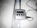
Yet another frozen geohash.
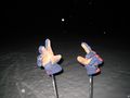
Look, no hands!
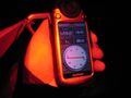
Proof


Achievements
Fasanen earned the Land geohash achievement
|
