Difference between revisions of "2010-12-29 45 -122"
From Geohashing
imported>Jiml (Add some details) |
imported>FippeBot m (Location) |
||
| (2 intermediate revisions by one other user not shown) | |||
| Line 1: | Line 1: | ||
| − | |||
| − | |||
<!-- If you did not specify these parameters in the template, please substitute appropriate values for IMAGE, LAT, LON, and DATE (YYYY-MM-DD format) | <!-- If you did not specify these parameters in the template, please substitute appropriate values for IMAGE, LAT, LON, and DATE (YYYY-MM-DD format) | ||
| Line 25: | Line 23: | ||
== Plans == | == Plans == | ||
| − | Traveling from Washington | + | Traveling from California to Washington, stopping near Salem. |
== Expedition == | == Expedition == | ||
| Line 32: | Line 30: | ||
From the User Page: | From the User Page: | ||
| − | My first geohash today. I was coming home to Stevenson, WA from Humboldt in NoCal and stopped outside Salem OR, in the bottom corner of the Portland graticule at 45.029225°, -122.973691. 1/2 way from the equator to the pole | + | My first geohash today. I was coming home to Stevenson, WA from Humboldt in NoCal |
| + | and stopped outside Salem OR, in the bottom corner of the Portland | ||
| + | graticule at 45.029225°, -122.973691. 1/2 way from the equator to the pole. | ||
| + | When leaving my hotel this morning in Grants Pass I checked for spots along the way. | ||
| + | This one was right off I-5. | ||
| + | |||
| + | So a quick exit and a short walk on a muddy field, & there I was. | ||
| + | |||
| + | Now all I have to do is learn how to post this info. | ||
| − | |||
| − | |||
== Photos == | == Photos == | ||
| − | |||
| − | |||
| − | |||
| − | |||
| − | |||
<gallery perrow="5"> | <gallery perrow="5"> | ||
| + | Image:GPS_in_mud.jpg | GPS and Mud, an eternal combination | ||
</gallery> | </gallery> | ||
| Line 52: | Line 52: | ||
<!-- Add any achievement ribbons you earned below, or remove this section --> | <!-- Add any achievement ribbons you earned below, or remove this section --> | ||
| − | + | {{Land geohash | |
| + | | lat=45 | ||
| + | | lon=-122 | ||
| + | | date=2010-12-29 | ||
| + | }} | ||
| − | |||
| − | |||
| − | |||
| Line 64: | Line 65: | ||
[[Category:Coordinates reached]] | [[Category:Coordinates reached]] | ||
| + | {{location|US|OR|MR}} | ||
Latest revision as of 05:04, 9 August 2019
| Wed 29 Dec 2010 in 45,-122: 45.0292256, -122.9736908 geohashing.info google osm bing/os kml crox |
Location
Near Salem Oregon
Participants
Plans
Traveling from California to Washington, stopping near Salem.
Expedition
From the User Page:
My first geohash today. I was coming home to Stevenson, WA from Humboldt in NoCal and stopped outside Salem OR, in the bottom corner of the Portland graticule at 45.029225°, -122.973691. 1/2 way from the equator to the pole.
When leaving my hotel this morning in Grants Pass I checked for spots along the way. This one was right off I-5.
So a quick exit and a short walk on a muddy field, & there I was.
Now all I have to do is learn how to post this info.
Photos
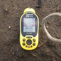
GPS and Mud, an eternal combination

Achievements
This user earned the Land geohash achievement
|