Difference between revisions of "2011-01-17 52 0"
imported>Sourcerer (Created page with "== Planned Expedition == Monday Jan 17th. The hashpoint is at Holkham Bay, north Norfolk on the beach at the western end of the nudist area. January has been unusually mild but...") |
imported>Sourcerer |
||
| Line 1: | Line 1: | ||
| − | == | + | == Location == |
| − | + | Near the western limit of the nudist beach at Holkham, North Norfolk, UK. | |
| − | + | {{meetup graticule | |
| + | | lat=52 | ||
| + | | lon=0 | ||
| + | | date=2011-01-17 | ||
| + | | graticule_name=Cambridge | ||
| + | | graticule_link=Cambridge, United Kingdom}} | ||
| − | + | == Participants == | |
| − | + | [[User:Sourcerer|Sourcerer]] | |
| − | + | == Expedition == | |
| + | |||
| + | The hashpoint is at Holkham Bay, north Norfolk on the beach near the western end of the nudist area. January has been unusually mild but Sourcerer (Neil) did '''not''' go naked. | ||
| + | |||
| + | The hashpoint could '''not''' be reached at high tide which was at about 5pm. With the moon nearing full and a clear but cold weather forecast, Neil arrived at about 8pm. The tide was going out. | ||
| + | |||
| + | Neil has two GPS logs on Wikiloc [http://www.wikiloc.com/wikiloc/view.do?id=83314 here] and [http://www.wikiloc.com/wikiloc/view.do?id=83311 here] which document previous treks to this area. The closer track log goes to within 60 metres of the hashpoint. The other is 190 metres away. The footpath was open and passable with evidence of recent maintenance work. Neil parked on the road as the harbour car park can flood at high tide. | ||
| + | |||
| + | Neil thinks this counts as a Déjà vu geohash achievement. He has two GPS tracks for visits in the autumn of 2007 once 60 metres away and then 190 metres. In the featureless beach landscape, this ought to qualify. It's certainly within hailing distance. Also he visits the area several times per year, walking from Burnham Overy Staithe to the Victoria hotel at Holkham for a beer, each time passing the hashpoint. How close depends on how high the tide is. | ||
| + | |||
| + | It was a fine moonlit night and thousands of over-wintering geese were grazing the grasslands and flying overhead. An owl flew over too. Many other mud-flat waders could be heard twittering. This is one of the most beautiful places on earth, hence the long drive to get there. | ||
| + | |||
| + | == Photo Gallery == | ||
| + | |||
| + | <gallery perrow="3"> | ||
| + | Image:2011-01-17_52_0_Sourcerer_1.jpg|Public Information Sign | ||
| + | Image:2011-01-17_52_0_Sourcerer_2.jpg|Moon Lit Night | ||
| + | Image:2011-01-17_52_0_Sourcerer_3.jpg|Danger Sign | ||
| + | Image:2011-01-17_52_0_Sourcerer_4.jpg|Fire Fighting Equipment (for the summer) | ||
| + | Image:2011-01-17_52_0_Sourcerer_5.jpg|Sand Dune Grasses | ||
| + | Image:2011-01-17_52_0_Sourcerer_6.jpg|Footpath Sign Posts | ||
| + | Image:2011-01-17_52_0_Sourcerer_7.jpg|Razor Shell XKCD Marker | ||
| + | Image:2011-01-17_52_0_Sourcerer_8.jpg|GPS says I'm 1 metre away! | ||
| + | Image:2011-01-17_52_0_Sourcerer_9.jpg|Night Time Calm Surf | ||
| + | Image:2011-01-17_52_0_Sourcerer_10.jpg|Google Earth Track Log | ||
| + | Image:2011-01-17_52_0_Sourcerer_11.jpg|Google Earth Close Up | ||
| + | </gallery> | ||
| + | |||
| + | == Achievements == | ||
| + | |||
| + | {{Déjà vu geohash | ||
| + | |||
| + | | latitude = 52 | ||
| + | | longitude = 0 | ||
| + | | date = 2011-01-17 | ||
| + | | olddate = 2007-10-20 | ||
| + | | name = Sourcerer | ||
| + | }} | ||
| + | |||
| + | == Other Geohashing Expeditions and Plans on This Day == | ||
| + | |||
| + | {{expedition summaries|2011-01-17}} | ||
| + | |||
| + | [[Category:Expeditions with photos]] | ||
| + | [[Category:Coordinates reached]] | ||
| + | [[Category:Meetup on 2011-01-17]] | ||
| + | [[Category:Meetup in 52 0]] | ||
Revision as of 10:54, 18 January 2011
Contents
Location
Near the western limit of the nudist beach at Holkham, North Norfolk, UK.
| Mon 17 Jan 2011 in Cambridge: 52.9771560, 0.7823476 geohashing.info google osm bing/os kml crox |
Participants
Expedition
The hashpoint is at Holkham Bay, north Norfolk on the beach near the western end of the nudist area. January has been unusually mild but Sourcerer (Neil) did not go naked.
The hashpoint could not be reached at high tide which was at about 5pm. With the moon nearing full and a clear but cold weather forecast, Neil arrived at about 8pm. The tide was going out.
Neil has two GPS logs on Wikiloc here and here which document previous treks to this area. The closer track log goes to within 60 metres of the hashpoint. The other is 190 metres away. The footpath was open and passable with evidence of recent maintenance work. Neil parked on the road as the harbour car park can flood at high tide.
Neil thinks this counts as a Déjà vu geohash achievement. He has two GPS tracks for visits in the autumn of 2007 once 60 metres away and then 190 metres. In the featureless beach landscape, this ought to qualify. It's certainly within hailing distance. Also he visits the area several times per year, walking from Burnham Overy Staithe to the Victoria hotel at Holkham for a beer, each time passing the hashpoint. How close depends on how high the tide is.
It was a fine moonlit night and thousands of over-wintering geese were grazing the grasslands and flying overhead. An owl flew over too. Many other mud-flat waders could be heard twittering. This is one of the most beautiful places on earth, hence the long drive to get there.
Photo Gallery
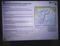
Public Information Sign
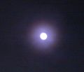
Moon Lit Night

Danger Sign
Fire Fighting Equipment (for the summer)
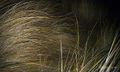
Sand Dune Grasses
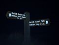
Footpath Sign Posts
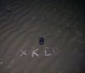
Razor Shell XKCD Marker
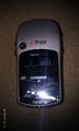
GPS says I'm 1 metre away!
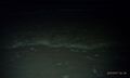
Night Time Calm Surf
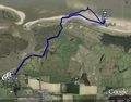
Google Earth Track Log
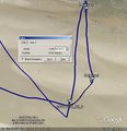
Google Earth Close Up


Achievements
Sourcerer earned the Déjà Vu Geohash Achievement
|
Other Geohashing Expeditions and Plans on This Day
Expeditions and Plans
| 2011-01-17 | ||
|---|---|---|
| Pforzheim, Germany | Ekorren | In a forest between Ötisheim, Ölbronn and Maulbronn |
| Cambridge, United Kingdom | Sourcerer | Near the western limit of the nudist beach at Holkham, North Norfolk, UK. |