Difference between revisions of "2011-01-21 66 25"
imported>Isopekka |
imported>FippeBot m (Location) |
||
| (9 intermediate revisions by 3 users not shown) | |||
| Line 1: | Line 1: | ||
| − | [[Image: | + | [[Image:Gh1-2011 008.JPG|thumb|left]] |
| Line 12: | Line 12: | ||
== Location == | == Location == | ||
| − | In the city of Rovaniemi | + | In the city of Rovaniemi, only 1.49 km from home (as the crow flies). |
| Line 20: | Line 20: | ||
* [[User:isopekka|isopekka]] | * [[User:isopekka|isopekka]] | ||
| + | |||
== Plan == | == Plan == | ||
| − | Planning to visit the hash at first midnight. | + | Planning to visit the hash at the first midnight. |
| + | |||
== Expedition == | == Expedition == | ||
| + | The hashpoint situated 1.49 km from home near the top of the highest hill in the city of Rovaniemi, at the hill "Ounasvaara". On the way to the hash there is The Santa Sport Center. This hash was almost "drive-in hash", I had to walk only about 60 meters. | ||
| + | There is a geocache [http://www.geocaching.com/seek/cache_details.aspx?guid=c0741935-fab3-48a7-b45d-314f8a114992 GC1F3C9 ] near the hash, only 67 meters to the west from the hash and clearly seen from the hash, at least at daytime... I have logged it about two years ago [http://www.geocaching.com/seek/log.aspx?LUID=bb382ea4-1146-46d3-9ddd-722c8a1291c3 2008-09-03], but now I could not dig it out from the snow and ice to get the Hash Collision Achievement. Unfortunately there is no achievement for previous logged geocaches near the hashes?? It should be! | ||
| − | + | Yesterday I have learned how to get screenshots from Colorado 300. Fine! No more Techology Loser Feelings attempting to photograph in darkness and coldness. The Colorado's right "soft button" saved me!. | |
| − | |||
| − | |||
| − | |||
| + | * By car total 5 km | ||
| + | * Walking total about 100 m | ||
| + | * Physical efforts needed (1-5): 1 | ||
==Photos == | ==Photos == | ||
| − | |||
<gallery perrow=4> | <gallery perrow=4> | ||
| − | Image: | + | Image:Gh1-2011 001.JPG | So, I will take the car on the left... |
| − | Image: | + | Image:Gh1-2011 002.JPG| Time on the way to the hashpoint. |
| − | Image: | + | Image:Gh1-2011 003.JPG| Temperature on the way to the hashpoint. |
| − | + | Image:Gh1-2011 004.JPG |Santa Sport, the main sport center in Rovaniemi. | |
| + | Image:Gh1-2011 005.JPG |The house of the local skiing club, 60 meters to the hash. | ||
| + | Image:Gh1-2011 008.JPG| The fence leading to the Hash. | ||
| + | Image:Gh1-2011 009.JPG | At the hashpoint about 11:45 p.m. | ||
| + | Image:Gh1-2011 010.JPG | Waiting for the midnight. | ||
| + | Image:Screen at 00.00.jpg| Screenshot at 00:00 | ||
| + | Image:Screen at 00.01.jpg| Screenshot at 00:01 | ||
| + | Image:MapSource-left part.jpg| Screenshot from MapSource, left part of the window showing date and time | ||
| + | Image:MapSource right part.jpg| Screenshot from MapSource, right part of the window showing location | ||
| + | Image:Gh1-2011 017.JPG | The thermometer. | ||
| + | Image:Gh1-2011 018.JPG| View from the hashpoint towards to the house of skiing club. | ||
| + | Image:Gh1-2011 019.JPG| Nice picnic place about 10 meters from the hash. | ||
| + | Image:Gh1-2011 021.JPG |The house of the skiing club as seen from the south. | ||
</gallery> | </gallery> | ||
| Line 62: | Line 77: | ||
}} | }} | ||
| + | |||
| + | {{Frozen Geohash | ||
| + | |||
| + | | latitude = 66 | ||
| + | | longitude = 25 | ||
| + | | date = 2011-01-21 | ||
| + | | temperature = -9.3°C | ||
| + | | name = isopekka | ||
| + | | image = | ||
| + | |||
| + | }} | ||
| + | |||
| + | {{Midnight geohash | ||
| + | |||
| + | | latitude = 66 | ||
| + | | longitude = 25 | ||
| + | | date = 2011-01-21 | ||
| + | | name = isopekka | ||
| + | | image = Gh1-2011 010.JPG | ||
| + | |||
| + | }} | ||
| + | |||
| Line 69: | Line 106: | ||
| − | [[Category: | + | [[Category:Expeditions]] |
| + | [[Category:Coordinates reached]] | ||
| + | [[Category:Expeditions with photos]] | ||
| + | {{location|FI|10}} | ||
Latest revision as of 05:18, 9 August 2019

| Fri 21 Jan 2011 in 66,25: 66.5010444, 25.7825491 geohashing.info google osm bing/os kml crox |
Contents
Location
In the city of Rovaniemi, only 1.49 km from home (as the crow flies).
Participants
Plan
Planning to visit the hash at the first midnight.
Expedition
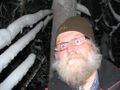
The hashpoint situated 1.49 km from home near the top of the highest hill in the city of Rovaniemi, at the hill "Ounasvaara". On the way to the hash there is The Santa Sport Center. This hash was almost "drive-in hash", I had to walk only about 60 meters.
There is a geocache GC1F3C9 near the hash, only 67 meters to the west from the hash and clearly seen from the hash, at least at daytime... I have logged it about two years ago 2008-09-03, but now I could not dig it out from the snow and ice to get the Hash Collision Achievement. Unfortunately there is no achievement for previous logged geocaches near the hashes?? It should be!
Yesterday I have learned how to get screenshots from Colorado 300. Fine! No more Techology Loser Feelings attempting to photograph in darkness and coldness. The Colorado's right "soft button" saved me!.
- By car total 5 km
- Walking total about 100 m
- Physical efforts needed (1-5): 1
Photos
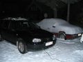
So, I will take the car on the left...
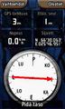
Time on the way to the hashpoint.
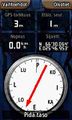
Temperature on the way to the hashpoint.
Santa Sport, the main sport center in Rovaniemi.
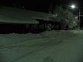
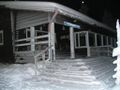
The house of the local skiing club, 60 meters to the hash.
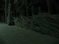
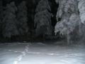
The fence leading to the Hash.
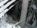
At the hashpoint about 11:45 p.m.
Waiting for the midnight.
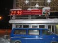
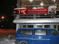
Screenshot at 00:00
Screenshot at 00:01
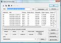
Screenshot from MapSource, left part of the window showing date and time
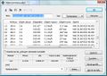
Screenshot from MapSource, right part of the window showing location

The thermometer.
View from the hashpoint towards to the house of skiing club.
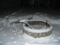
Nice picnic place about 10 meters from the hash.
The house of the skiing club as seen from the south.


Achievements
isopekka earned the Land geohash achievement
|

isopekka earned the Midnight Geohash achievement
|
Other Geohashing Expeditions and Plans on This Day
Expeditions and Plans
| 2011-01-21 | ||
|---|---|---|
| Atlanta, Georgia | NWoodruff | In the middle of a road in Lilburn Georgia |
| Zürich, Switzerland | Wuestenschiff | On the border between the town of Winterthur and the village Elsau |
| Hamburg (West), Germany | Hermann | An apple farm near "Buxtehude". |
| Tampere, Finland | Laiti | The spot is located at Tammela near Tampere city centre. Very urban area. |
| Rovaniemi, Finland | isopekka | In the city of Rovaniemi, only 1.49 km from home (as the crow flies). |